Santa Isabel, São Paulo
Santa Isabel | |||
|---|---|---|---|
 | |||
| |||
| Nickname(s): Paraíso da Grande São Paulo ("Greater São Paulo's paradise") | |||
 Location of Santa Isabel | |||
 Santa Isabel Location of Santa Isabel | |||
| Coordinates: 23°18′57″S 46°13′15″W / 23.31583°S 46.22083°W / -23.31583; -46.22083Coordinates: 23°18′57″S 46°13′15″W / 23.31583°S 46.22083°W / -23.31583; -46.22083 | |||
| Country | |||
| Region | Southeast | ||
| State | |||
| Government | |||
| • Mayor | Fábia Porto Rossetti (PRB) | ||
| Area | |||
| • Total | 363.33 km2 (140.28 sq mi) | ||
| Population (2015)[1] | |||
| • Total | 54,926 | ||
| • Density | 150/km2 (390/sq mi) | ||
| Time zone | UTC-3 (UTC-3) | ||
| • Summer (DST) | UTC-2 (UTC-2) | ||
HDI (2000) | 0,766 medium | ||
| Website | Santa Isabel City Hall | ||


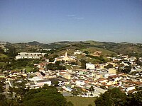
Street Juscelino Kubitschek in Vila Nova Santa Isabel.
Santa Isabel (Portuguese pronunciation: [ˈsɐ̃tɐ jzɐˈbɛw]) is a municipality in the state of São Paulo in Brazil. It is part of the Metropolitan Region of São Paulo.[2] The population is 54,926 (2015 est.) in an area of 363.33 km².[1] The elevation is 655 m. It is located 60 miles east of the downtown of the city of São Paulo.
History
The town of Santa Isabel was named after a Portuguese queen, Isabel or Elizabeth of Aragon (b. 1271- d. 1336), who was canonized by Pope Urban VIII in 1625. The town was founded in the 18th century, when Brazil was still a colony of Portugal.
Geography and ecology
Santa Isabel belongs to the Guarulhos macro region, thus it is part of the Greater São Paulo region as well. The municipality lies in the basins of the Rio Jaguari and the Rio Paraíba do Sul and 84% of the municipality is protected by environmental laws because of its significance as a potable water source [3]
The municipality contains part of the 292,000 hectares (720,000 acres) Mananciais do Rio Paraíba do Sul Environmental Protection Area, created in 1982 to protect the sources of the Paraíba do Sul.[4]
The area suffered ecologically from unauthorized uses and in 1996 the Ibirapitanga Reserve on the Rio dos Pilões was created to preserve one of the last stands of Brazilian Atlantic forest and to permit managed urban growth.[3]
References
^ ab Instituto Brasileiro de Geografia e Estatística
^ Lei Complementar nº 1.139, de 16 de junho de 2011
^ ab "Reserva Ibirapitanga - Histórico (Ibirapitanga Reserve - History)" (in Portuguese). Associação dos Proprietários em Reserva Ibirapitanga (APRI)..mw-parser-output cite.citationfont-style:inherit.mw-parser-output .citation qquotes:"""""""'""'".mw-parser-output .citation .cs1-lock-free abackground:url("//upload.wikimedia.org/wikipedia/commons/thumb/6/65/Lock-green.svg/9px-Lock-green.svg.png")no-repeat;background-position:right .1em center.mw-parser-output .citation .cs1-lock-limited a,.mw-parser-output .citation .cs1-lock-registration abackground:url("//upload.wikimedia.org/wikipedia/commons/thumb/d/d6/Lock-gray-alt-2.svg/9px-Lock-gray-alt-2.svg.png")no-repeat;background-position:right .1em center.mw-parser-output .citation .cs1-lock-subscription abackground:url("//upload.wikimedia.org/wikipedia/commons/thumb/a/aa/Lock-red-alt-2.svg/9px-Lock-red-alt-2.svg.png")no-repeat;background-position:right .1em center.mw-parser-output .cs1-subscription,.mw-parser-output .cs1-registrationcolor:#555.mw-parser-output .cs1-subscription span,.mw-parser-output .cs1-registration spanborder-bottom:1px dotted;cursor:help.mw-parser-output .cs1-ws-icon abackground:url("//upload.wikimedia.org/wikipedia/commons/thumb/4/4c/Wikisource-logo.svg/12px-Wikisource-logo.svg.png")no-repeat;background-position:right .1em center.mw-parser-output code.cs1-codecolor:inherit;background:inherit;border:inherit;padding:inherit.mw-parser-output .cs1-hidden-errordisplay:none;font-size:100%.mw-parser-output .cs1-visible-errorfont-size:100%.mw-parser-output .cs1-maintdisplay:none;color:#33aa33;margin-left:0.3em.mw-parser-output .cs1-subscription,.mw-parser-output .cs1-registration,.mw-parser-output .cs1-formatfont-size:95%.mw-parser-output .cs1-kern-left,.mw-parser-output .cs1-kern-wl-leftpadding-left:0.2em.mw-parser-output .cs1-kern-right,.mw-parser-output .cs1-kern-wl-rightpadding-right:0.2em
^ Unidade de Conservação: Área de Proteção Ambiental Bacia Hidrográfica do Paraíba do Sul (in Portuguese), MMA: Ministério do Meio Ambiente, retrieved 2016-10-01
This geographical article relating to the state of São Paulo is a stub. You can help Wikipedia by expanding it. |
