National Register of Historic Places listings in Sussex County, Virginia
[dummy-text]
National Register of Historic Places listings in Sussex County, Virginia
Jump to navigation
Jump to search
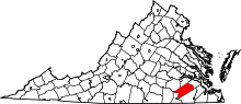
Location of Sussex County in Virginia
This is a list of the National Register of Historic Places listings in Sussex County, Virginia.
This is intended to be a complete list of the properties and districts on the National Register of Historic Places in Sussex County, Virginia, United States. The locations of National Register properties and districts for which the latitude and longitude coordinates are included below, may be seen in a Google map.[1]
There are 9 properties and districts listed on the National Register in the county.
This National Park Service list is complete through NPS recent listings posted November 2, 2018.[2]
Current listings[edit]
| [3] | Name on the Register[4] | Image | Date listed[5] | Location | City or town | Description |
|---|---|---|---|---|---|---|
1 | Miles B. Carpenter House |  | November 13, 1989 (#89001920) | U.S. Route 460 37°02′17″N 77°05′38″W / 37.038056°N 77.093889°W / 37.038056; -77.093889 (Miles B. Carpenter House) | Waverly | |
2 | Chester | 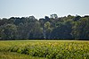 | December 18, 1970 (#70000829) | North of the junction of State Route 35 and Newville Rd. 36°58′19″N 77°10′46″W / 36.972083°N 77.179444°W / 36.972083; -77.179444 (Chester) | Homeville | |
3 | Fortsville | 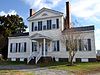 | September 15, 1970 (#70000828) | Southeast of the junction of Grizzard and Fortsville Rds. 36°42′49″N 77°25′08″W / 36.713611°N 77.418889°W / 36.713611; -77.418889 (Fortsville) | Grizzard | Straddles the border with Southampton County |
4 | Glenview |  | November 26, 2008 (#08001114) | 13098 Comans Well Rd. 36°52′15″N 77°24′19″W / 36.870833°N 77.405278°W / 36.870833; -77.405278 (Glenview) | Stony Creek | |
5 | Hunting Quarter |  | April 7, 1995 (#95000396) | Hunting Quarter Rd., south of its junction with Poole Rd. 36°52′08″N 77°13′26″W / 36.868750°N 77.223889°W / 36.868750; -77.223889 (Hunting Quarter) | Waverly | |
6 | Little Town |  | November 18, 1976 (#76002124) | West of Littleton on Cool Spring Rd. 36°54′25″N 77°10′17″W / 36.906944°N 77.171389°W / 36.906944; -77.171389 (Little Town) | Littleton | |
7 | Nottoway Archeological Site (44SX6, 44SX7, 44SX98, 44SX162) | November 3, 1988 (#88002181) | Address Restricted | Stony Creek | ||
8 | Sussex County Courthouse Historic District | 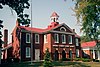 | July 24, 1973 (#73002066) | Junction of Courthouse and Old Forty Rds. 36°54′55″N 77°16′47″W / 36.915278°N 77.279722°W / 36.915278; -77.279722 (Sussex County Courthouse Historic District) | Sussex | |
9 | Waverly Downtown Historic District |  | May 28, 2013 (#13000344) | Generally surrounding W. Main St. from County Dr. west to Coppahaunk Ave. 37°02′09″N 77°05′44″W / 37.035833°N 77.095556°W / 37.035833; -77.095556 (Waverly Downtown Historic District) | Waverly | Forty-eight contributing buildings, one contributing site, and two contributing structures.[6] |
See also[edit]
| Wikimedia Commons has media related to National Register of Historic Places in Sussex County, Virginia. |
- List of National Historic Landmarks in Virginia
- National Register of Historic Places listings in Virginia
References[edit]
^ The latitude and longitude information provided in this table was derived originally from the National Register Information System, which has been found to be fairly accurate for about 99% of listings. For about 1% of NRIS original coordinates, experience has shown that one or both coordinates are typos or otherwise extremely far off; some corrections may have been made. A more subtle problem causes many locations to be off by up to 150 yards, depending on location in the country: most NRIS coordinates were derived from tracing out latitude and longitudes from USGS topographical quadrant maps created under the North American Datum of 1927, which differs from the current, highly accurate WGS84 GPS system used by most on-line maps. Chicago is about right, but NRIS longitudes in Washington are higher by about 4.5 seconds, and are lower by about 2.0 seconds in Maine. Latitudes differ by about 1.0 second in Florida. Some locations in this table may have been corrected to current GPS standards.
^ "National Register of Historic Places: Weekly List Actions". National Park Service, United States Department of the Interior. Retrieved on November 2, 2018.
^ Numbers represent an ordering by significant words. Various colorings, defined here, differentiate National Historic Landmarks and historic districts from other NRHP buildings, structures, sites or objects.
^ National Park Service (2008-04-24). "National Register Information System". National Register of Historic Places. National Park Service..mw-parser-output cite.citationfont-style:inherit.mw-parser-output qquotes:"""""""'""'".mw-parser-output code.cs1-codecolor:inherit;background:inherit;border:inherit;padding:inherit.mw-parser-output .cs1-lock-free abackground:url("//upload.wikimedia.org/wikipedia/commons/thumb/6/65/Lock-green.svg/9px-Lock-green.svg.png")no-repeat;background-position:right .1em center.mw-parser-output .cs1-lock-limited a,.mw-parser-output .cs1-lock-registration abackground:url("//upload.wikimedia.org/wikipedia/commons/thumb/d/d6/Lock-gray-alt-2.svg/9px-Lock-gray-alt-2.svg.png")no-repeat;background-position:right .1em center.mw-parser-output .cs1-lock-subscription abackground:url("//upload.wikimedia.org/wikipedia/commons/thumb/a/aa/Lock-red-alt-2.svg/9px-Lock-red-alt-2.svg.png")no-repeat;background-position:right .1em center.mw-parser-output .cs1-subscription,.mw-parser-output .cs1-registrationcolor:#555.mw-parser-output .cs1-subscription span,.mw-parser-output .cs1-registration spanborder-bottom:1px dotted;cursor:help.mw-parser-output .cs1-hidden-errordisplay:none;font-size:100%.mw-parser-output .cs1-visible-errorfont-size:100%.mw-parser-output .cs1-subscription,.mw-parser-output .cs1-registration,.mw-parser-output .cs1-formatfont-size:95%.mw-parser-output .cs1-kern-left,.mw-parser-output .cs1-kern-wl-leftpadding-left:0.2em.mw-parser-output .cs1-kern-right,.mw-parser-output .cs1-kern-wl-rightpadding-right:0.2em
^ The eight-digit number below each date is the number assigned to each location in the National Register Information System database, which can be viewed by clicking the number.
^ NPS
U.S. National Register of Historic Places in Virginia | ||
|---|---|---|
| Lists by county |
|   |
| Lists by city |
| |
| Other lists |
| |
| ||
Municipalities and communities of Sussex County, Virginia, United States | ||
|---|---|---|
County seat: Sussex | ||
| Towns |
|  |
| CDP |
| |
| Unincorporated communities |
| |
| Footnotes | ‡This populated place also has portions in an adjacent county or counties | |
Categories:
- National Register of Historic Places in Sussex County, Virginia
- Lists of National Register of Historic Places in Virginia by county
(window.RLQ=window.RLQ||).push(function()mw.config.set("wgPageParseReport":"limitreport":"cputime":"0.388","walltime":"0.499","ppvisitednodes":"value":4542,"limit":1000000,"ppgeneratednodes":"value":0,"limit":1500000,"postexpandincludesize":"value":112807,"limit":2097152,"templateargumentsize":"value":5862,"limit":2097152,"expansiondepth":"value":11,"limit":40,"expensivefunctioncount":"value":0,"limit":500,"unstrip-depth":"value":1,"limit":20,"unstrip-size":"value":5811,"limit":5000000,"entityaccesscount":"value":1,"limit":400,"timingprofile":["100.00% 357.683 1 -total"," 36.96% 132.201 1 Template:NRHP_header"," 34.77% 124.360 9 Template:NRHP_row"," 31.00% 110.879 1 Template:NRISref"," 29.58% 105.798 1 Template:Cite_web"," 8.57% 30.654 1 Template:Commons_category"," 8.37% 29.941 14 Template:NRHP_color"," 8.34% 29.834 10 Template:Designation/color"," 7.96% 28.465 8 Template:Coord"," 7.52% 26.904 19 Template:First_word"],"scribunto":"limitreport-timeusage":"value":"0.118","limit":"10.000","limitreport-memusage":"value":3585752,"limit":52428800,"cachereport":"origin":"mw1336","timestamp":"20181112222814","ttl":1900800,"transientcontent":false);mw.config.set("wgBackendResponseTime":89,"wgHostname":"mw1251"););


