National Register of Historic Places listings in Warren County, Virginia
[dummy-text]
National Register of Historic Places listings in Warren County, Virginia
Jump to navigation
Jump to search

Location of Warren County in Virginia
This is a list of the National Register of Historic Places listings in Warren County, Virginia.
This is intended to be a complete list of the properties and districts on the National Register of Historic Places in Warren County, Virginia, United States. The locations of National Register properties and districts for which the latitude and longitude coordinates are included below, may be seen in a Google map.[1]
There are 23 properties and districts listed on the National Register in the county, including 3 National Historic Landmarks.
This National Park Service list is complete through NPS recent listings posted November 2, 2018.[2]
Current listings[edit]
| [3] | Name on the Register[4] | Image | Date listed[5] | Location | City or town | Description |
|---|---|---|---|---|---|---|
1 | Balthis House |  | August 11, 2004 (#04000860) | 55 Chester St. 38°55′10″N 78°11′28″W / 38.919444°N 78.191111°W / 38.919444; -78.191111 (Balthis House) | Front Royal | |
2 | Cedar Creek Battlefield and Belle Grove |  | August 11, 1969 (#69000243) | On Interstate 81 between Middletown and Strasburg 39°00′00″N 78°18′40″W / 39.000000°N 78.311111°W / 39.000000; -78.311111 (Cedar Creek Battlefield and Belle Grove) | Middletown | Site of the Battle of Cedar Creek; designated a National Historic Landmark District in 1969. Extends into Frederick County. |
3 | Compton Gap Site |  | December 13, 1985 (#85003176) | Address Restricted | Luray | |
4 | Erin |  | December 28, 1979 (#79003093) | Northeast of Front Royal on U.S. Routes 340/522 39°01′22″N 78°09′34″W / 39.022778°N 78.159444°W / 39.022778; -78.159444 (Erin) | Front Royal | |
5 | Fairview Farm |  | June 5, 1986 (#86001249) | Rockland Rd. 38°59′40″N 78°07′53″W / 38.994444°N 78.131389°W / 38.994444; -78.131389 (Fairview Farm) | Front Royal | |
6 | Flint Run Archeological District |  | December 22, 1976 (#76002125) | Straddling the Shenandoah River below Karo[6] 38°52′07″N 78°15′15″W / 38.868611°N 78.254167°W / 38.868611; -78.254167 (Flint Run Archeological District) | Front Royal | Includes the Thunderbird Archeological District; occupies both sides of the river[6] |
7 | Front Royal Historic District |  | April 11, 2003 (#03000209) | Irregular district around E. and W. Main St., and S. Royal Ave. 38°55′05″N 78°11′34″W / 38.918056°N 78.192778°W / 38.918056; -78.192778 (Front Royal Historic District) | Front Royal | |
8 | Front Royal Recreational Park Historic District |  | October 27, 1992 (#91001975) | Country Club Rd., 1.1 miles (1.8 km) north of Riverton off U.S. Route 522 38°57′30″N 78°11′10″W / 38.958333°N 78.186111°W / 38.958333; -78.186111 (Front Royal Recreational Park Historic District) | Front Royal | |
9 | Killahevlin |  | October 14, 1993 (#93001128) | 1401 N. Royal Ave. 38°56′13″N 78°11′37″W / 38.936806°N 78.193611°W / 38.936806; -78.193611 (Killahevlin) | Front Royal | |
10 | Lackawanna |  | May 16, 2014 (#14000240) | 236 Riverside Dr. 38°56′43″N 78°11′39″W / 38.945278°N 78.194167°W / 38.945278; -78.194167 (Lackawanna) | Front Royal | |
11 | Long Meadow | 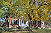 | October 12, 1995 (#95001169) | Long Meadow Rd. about 0.9 miles south of its junction with Water Plant Rd. 38°59′02″N 78°18′08″W / 38.983889°N 78.302222°W / 38.983889; -78.302222 (Long Meadow) | Middletown | |
12 | Milford Battlefield |  | August 11, 2004 (#04000854) | U.S. Route 340 and Overall Rd. 38°48′44″N 78°20′36″W / 38.812222°N 78.343333°W / 38.812222; -78.343333 (Milford Battlefield) | Overall | Extends into Page County |
13 | Mount Zion |  | February 26, 1970 (#70000830) | Northeast of the junction of Milldale and Ashley Station Rds. 39°00′07″N 78°05′59″W / 39.001944°N 78.099722°W / 39.001944; -78.099722 (Mount Zion) | Milldale | |
13 | Mountain House |  | August 8, 2007 (#07000801) | 2471 Remound Rd. 38°52′30″N 78°08′41″W / 38.875000°N 78.144722°W / 38.875000; -78.144722 (Mountain House) | Front Royal | |
15 | Page County Bridge No. 1990 |  | May 15, 2008 (#08000423) | U.S. Route 340 38°48′23″N 78°20′55″W / 38.806389°N 78.348750°W / 38.806389; -78.348750 (Page County Bridge No. 1990) | Overall | Extends into Page County |
16 | Riverside |  | October 12, 1995 (#95001172) | 1315 Old Winchester Pike 38°56′42″N 78°11′47″W / 38.945000°N 78.196250°W / 38.945000; -78.196250 (Riverside) | Front Royal | |
17 | Riverton Historic District |  | May 16, 2002 (#02000514) | Roughly along Crisman Dr., Duck St., Old Winchester Pike, the Queens Highway, Riverside Dr., Rugby St., and Strasburg Rd. 38°56′46″N 78°11′41″W / 38.946111°N 78.194722°W / 38.946111; -78.194722 (Riverton Historic District) | Front Royal | |
18 | Rockland Rural Historic District |  | November 17, 2015 (#15000809) | Roughly bounded by the Clarke County line, the Shenandoah River, Winchester Rd., and the Norfolk Southern railroad line 39°00′06″N 78°05′56″W / 39.001667°N 78.098889°W / 39.001667; -78.098889 (Rockland Rural Historic District) | Front Royal | |
19 | Rose Hill |  | May 23, 1996 (#96000578) | 900 block of N. Royal Ave. 38°55′49″N 78°11′43″W / 38.930278°N 78.195278°W / 38.930278; -78.195278 (Rose Hill) | Front Royal | |
20 | Skyline Drive Historic District |  | April 28, 1997 (#97000375) | Shenandoah National Park, from the northern entrance station at Front Royal to the southern entrance station at Rockfish Gap 38°46′49″N 78°12′10″W / 38.780278°N 78.202778°W / 38.780278; -78.202778 (Skyline Drive Historic District) | Luray | |
21 | Sonner Hall |  | January 29, 1987 (#87000007) | 3rd St. 38°55′23″N 78°11′53″W / 38.923056°N 78.198056°W / 38.923056; -78.198056 (Sonner Hall) | Front Royal | |
22 | Thunderbird Archeological District | 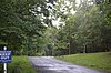 | May 5, 1977 (#77001495) | Northern edge of the Shenandoah River floodplain, west of Kano[6] 38°52′10″N 78°16′19″W / 38.869444°N 78.271944°W / 38.869444; -78.271944 (Thunderbird Archeological District) | Limeton | |
23 | Warren County Courthouse | 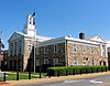 | January 28, 2000 (#00000028) | 1 E. Main St. 38°55′03″N 78°11′35″W / 38.917500°N 78.193056°W / 38.917500; -78.193056 (Warren County Courthouse) | Front Royal |
See also[edit]
| Wikimedia Commons has media related to National Register of Historic Places in Warren County, Virginia. |
- List of National Historic Landmarks in Virginia
- National Register of Historic Places listings in Virginia
References[edit]
^ The latitude and longitude information provided in this table was derived originally from the National Register Information System, which has been found to be fairly accurate for about 99% of listings. For about 1% of NRIS original coordinates, experience has shown that one or both coordinates are typos or otherwise extremely far off; some corrections may have been made. A more subtle problem causes many locations to be off by up to 150 yards, depending on location in the country: most NRIS coordinates were derived from tracing out latitude and longitudes from USGS topographical quadrant maps created under the North American Datum of 1927, which differs from the current, highly accurate WGS84 GPS system used by most on-line maps. Chicago is about right, but NRIS longitudes in Washington are higher by about 4.5 seconds, and are lower by about 2.0 seconds in Maine. Latitudes differ by about 1.0 second in Florida. Some locations in this table may have been corrected to current GPS standards.
^ "National Register of Historic Places: Weekly List Actions". National Park Service, United States Department of the Interior. Retrieved on November 2, 2018.
^ Numbers represent an ordering by significant words. Various colorings, defined here, differentiate National Historic Landmarks and historic districts from other NRHP buildings, structures, sites or objects.
^ National Park Service (2008-04-24). "National Register Information System". National Register of Historic Places. National Park Service..mw-parser-output cite.citationfont-style:inherit.mw-parser-output qquotes:"""""""'""'".mw-parser-output code.cs1-codecolor:inherit;background:inherit;border:inherit;padding:inherit.mw-parser-output .cs1-lock-free abackground:url("//upload.wikimedia.org/wikipedia/commons/thumb/6/65/Lock-green.svg/9px-Lock-green.svg.png")no-repeat;background-position:right .1em center.mw-parser-output .cs1-lock-limited a,.mw-parser-output .cs1-lock-registration abackground:url("//upload.wikimedia.org/wikipedia/commons/thumb/d/d6/Lock-gray-alt-2.svg/9px-Lock-gray-alt-2.svg.png")no-repeat;background-position:right .1em center.mw-parser-output .cs1-lock-subscription abackground:url("//upload.wikimedia.org/wikipedia/commons/thumb/a/aa/Lock-red-alt-2.svg/9px-Lock-red-alt-2.svg.png")no-repeat;background-position:right .1em center.mw-parser-output .cs1-subscription,.mw-parser-output .cs1-registrationcolor:#555.mw-parser-output .cs1-subscription span,.mw-parser-output .cs1-registration spanborder-bottom:1px dotted;cursor:help.mw-parser-output .cs1-hidden-errordisplay:none;font-size:100%.mw-parser-output .cs1-visible-errorfont-size:100%.mw-parser-output .cs1-subscription,.mw-parser-output .cs1-registration,.mw-parser-output .cs1-formatfont-size:95%.mw-parser-output .cs1-kern-left,.mw-parser-output .cs1-kern-wl-leftpadding-left:0.2em.mw-parser-output .cs1-kern-right,.mw-parser-output .cs1-kern-wl-rightpadding-right:0.2em
^ The eight-digit number below each date is the number assigned to each location in the National Register Information System database, which can be viewed by clicking the number.
^ abc Gardner, William M., ed. The Flint Run Paleo-Indian Complex : A Preliminary Report 1971-73 Seasons. Washington : Archeology Laboratory, Dept. of Anthropology, Catholic University of America, 1974, 7.
U.S. National Register of Historic Places in Virginia | ||
|---|---|---|
| Lists by county |
|   |
| Lists by city |
| |
| Other lists |
| |
| ||
Municipalities and communities of Warren County, Virginia, United States | ||
|---|---|---|
County seat: Front Royal | ||
| Town |
|  |
| CDPs |
| |
| Unincorporated communities |
| |
| Footnotes | ‡This populated place also has portions in an adjacent county or counties | |
Categories:
- National Register of Historic Places in Warren County, Virginia
- Lists of National Register of Historic Places in Virginia by county
(window.RLQ=window.RLQ||).push(function()mw.config.set("wgPageParseReport":"limitreport":"cputime":"0.696","walltime":"0.909","ppvisitednodes":"value":9601,"limit":1000000,"ppgeneratednodes":"value":0,"limit":1500000,"postexpandincludesize":"value":191458,"limit":2097152,"templateargumentsize":"value":14103,"limit":2097152,"expansiondepth":"value":11,"limit":40,"expensivefunctioncount":"value":0,"limit":500,"unstrip-depth":"value":1,"limit":20,"unstrip-size":"value":6352,"limit":5000000,"entityaccesscount":"value":1,"limit":400,"timingprofile":["100.00% 599.128 1 -total"," 50.59% 303.087 23 Template:NRHP_row"," 26.51% 158.809 1 Template:NRHP_header"," 21.48% 128.710 1 Template:NRISref"," 20.63% 123.600 1 Template:Cite_web"," 9.89% 59.234 46 Template:First_word"," 9.27% 55.561 22 Template:Designation/color"," 8.39% 50.238 22 Template:Coord"," 8.02% 48.028 21 Template:NRHP_color"," 7.42% 44.444 23 Template:Dts"],"scribunto":"limitreport-timeusage":"value":"0.197","limit":"10.000","limitreport-memusage":"value":6051269,"limit":52428800,"cachereport":"origin":"mw1303","timestamp":"20181112222813","ttl":1900800,"transientcontent":false);mw.config.set("wgBackendResponseTime":89,"wgHostname":"mw1275"););


