National Register of Historic Places listings in Wythe County, Virginia
[dummy-text]
National Register of Historic Places listings in Wythe County, Virginia
Jump to navigation
Jump to search

Location of Wythe County in Virginia
This is a list of the National Register of Historic Places listings in Wythe County, Virginia.
This is intended to be a complete list of the properties and districts on the National Register of Historic Places in Wythe County, Virginia, United States. The locations of National Register properties and districts for which the latitude and longitude coordinates are included below, may be seen in an online map.[1]
There are 21 properties and districts listed on the National Register in the county.
This National Park Service list is complete through NPS recent listings posted November 2, 2018.[2]
Current listings[edit]
| [3] | Name on the Register[4] | Image | Date listed[5] | Location | City or town | Description |
|---|---|---|---|---|---|---|
1 | Cornett Archeological Site (44WY1) |  | September 29, 1983 (#83003320) | New River below Austinville[6]:202 36°51′32″N 80°54′44″W / 36.858889°N 80.912222°W / 36.858889; -80.912222 (Cornett Archeological Site (44WY1)) | Austinville | |
2 | Crockett's Cove Presbyterian Church |  | October 15, 1992 (#92001373) | Crockett's Cove Rd., east of its junction with Smith Hollow Rd. 37°01′35″N 81°02′14″W / 37.026250°N 81.037222°W / 37.026250; -81.037222 (Crockett's Cove Presbyterian Church) | Wytheville | |
3 | Fort Chiswell Mansion | 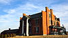 | May 6, 1971 (#71000992) | 325 Factory Outlet Drive; Interstate 81 near its junction with U.S. Route 52 and State Route 121 36°56′46″N 80°56′12″W / 36.946111°N 80.936667°W / 36.946111; -80.936667 (Fort Chiswell Mansion) | Fort Chiswell | |
4 | Fort Chiswell Site |  | August 29, 1978 (#78003046) | E Lee Highway 36°56′54″N 80°56′04″W / 36.948406°N 80.934319°W / 36.948406; -80.934319 (Fort Chiswell Site) | Fort Chiswell | |
5 | Foster Falls Historic District | 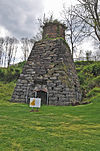 | November 12, 2009 (#09000925) | New River Trail State Park, 176 Orphanage Dr. 36°53′03″N 80°51′19″W / 36.884167°N 80.855278°W / 36.884167; -80.855278 (Foster Falls Historic District) | Max Meadows | |
6 | Graham's Forge Mill |  | May 26, 2005 (#05000481) | Major Graham Rd. 36°56′27″N 80°53′12″W / 36.940833°N 80.886667°W / 36.940833; -80.886667 (Graham's Forge Mill) | Max Meadows | |
7 | Maj. David Graham House |  | February 14, 1985 (#85000300) | Junction of Major Grahams and Carters Ferry Rds. 36°54′58″N 80°52′18″W / 36.916111°N 80.871667°W / 36.916111; -80.871667 (Maj. David Graham House) | Fosters Falls | |
8 | Haller-Gibboney Rock House | 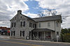 | November 9, 1972 (#72001419) | Monroe and Tazewell Sts. 36°57′02″N 81°05′04″W / 36.950556°N 81.084444°W / 36.950556; -81.084444 (Haller-Gibboney Rock House) | Wytheville | |
9 | Kimberling Lutheran Cemetery |  | March 26, 1980 (#80004231) | Northwest of Rural Retreat 36°55′05″N 81°18′17″W / 36.918056°N 81.304722°W / 36.918056; -81.304722 (Kimberling Lutheran Cemetery) | Rural Retreat | |
10 | Loretto |  | September 8, 1994 (#94001093) | 190 Peppers Ferry Rd. 36°57′27″N 81°04′49″W / 36.95750°N 81.080278°W / 36.95750; -81.080278 (Loretto) | Wytheville | |
11 | Martin Site | 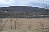 | August 13, 1974 (#74002152) | Bounded by Reed Creek Rd., the New River, and Reed Creek[6]:172 36°55′24″N 80°49′33″W / 36.923333°N 80.825833°W / 36.923333; -80.825833 (Martin Site) | Fosters Falls | |
12 | McGavock Family Cemetery |  | June 22, 1979 (#79003098) | East of Fort Chiswell off Interstate 81 36°56′52″N 80°55′29″W / 36.947778°N 80.924722°W / 36.947778; -80.924722 (McGavock Family Cemetery) | Fort Chiswell | |
13 | Reed Creek Mill |  | November 22, 2016 (#16000802) | 1565 S. Church St. 36°56′09″N 81°04′28″W / 36.935833°N 81.074444°W / 36.935833; -81.074444 (Reed Creek Mill) | Wytheville | |
14 | Rural Retreat Depot | August 25, 2014 (#14000531) | 105 Railroad Ave. 36°53′38″N 81°16′35″W / 36.893889°N 81.276389°W / 36.893889; -81.276389 (Rural Retreat Depot) | Rural Retreat | ||
15 | Sanders Farm |  | May 22, 2003 (#03000454) | 3908 Fort Chiswell Rd. 36°52′26″N 80°52′16″W / 36.873750°N 80.871111°W / 36.873750; -80.871111 (Sanders Farm) | Max Meadows | |
16 | Shot Tower | 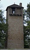 | October 1, 1969 (#69000286) | West of the junction of U.S. Route 52 with Foster Falls Rd. 36°52′13″N 80°52′13″W / 36.870194°N 80.870278°W / 36.870194; -80.870278 (Shot Tower) | Max Meadows | |
17 | St. John's Episcopal Church |  | September 9, 2008 (#08000894) | 275 E. Main St. 36°57′03″N 81°04′55″W / 36.950833°N 81.081944°W / 36.950833; -81.081944 (St. John's Episcopal Church) | Wytheville | |
18 | St. John's Lutheran Church and Cemetery | 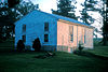 | January 26, 1978 (#78003047) | Northwest of Wytheville at the junction of U.S. Routes 21/52 with Interstate 81 36°57′42″N 81°06′03″W / 36.961667°N 81.100833°W / 36.961667; -81.100833 (St. John's Lutheran Church and Cemetery) | Wytheville | |
19 | Wythe County Poorhouse Farm |  | May 26, 2000 (#00000557) | Peppers Ferry Rd. 36°58′56″N 81°01′42″W / 36.982222°N 81.028333°W / 36.982222; -81.028333 (Wythe County Poorhouse Farm) | Wytheville | |
20 | Wytheville Historic District | 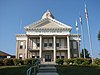 | September 30, 1994 (#94001179) | Roughly bounded by Monroe, 11th, Jefferson, and 12th Sts., and W. Railroad Ave. 36°56′50″N 81°05′04″W / 36.947222°N 81.084444°W / 36.947222; -81.084444 (Wytheville Historic District) | Wytheville | |
21 | Zion Evangelical Lutheran Church Cemetery |  | February 1, 1979 (#79003099) | Northwest of Speedwell 36°50′28″N 81°13′21″W / 36.841111°N 81.2225°W / 36.841111; -81.2225 (Zion Evangelical Lutheran Church Cemetery) | Speedwell |
See also[edit]
| Wikimedia Commons has media related to National Register of Historic Places in Wythe County, Virginia. |
- List of National Historic Landmarks in Virginia
- National Register of Historic Places listings in Virginia
References[edit]
^ The latitude and longitude information provided in this table was derived originally from the National Register Information System, which has been found to be fairly accurate for about 99% of listings. For about 1% of NRIS original coordinates, experience has shown that one or both coordinates are typos or otherwise extremely far off; some corrections may have been made. A more subtle problem causes many locations to be off by up to 150 yards, depending on location in the country: most NRIS coordinates were derived from tracing out latitude and longitudes from USGS topographical quadrant maps created under the North American Datum of 1927, which differs from the current, highly accurate WGS84 GPS system used by most on-line maps. Chicago is about right, but NRIS longitudes in Washington are higher by about 4.5 seconds, and are lower by about 2.0 seconds in Maine. Latitudes differ by about 1.0 second in Florida. Some locations in this table may have been corrected to current GPS standards.
^ "National Register of Historic Places: Weekly List Actions". National Park Service, United States Department of the Interior. Retrieved on November 2, 2018.
^ Numbers represent an ordering by significant words. Various colorings, defined here, differentiate National Historic Landmarks and historic districts from other NRHP buildings, structures, sites or objects.
^ National Park Service (2008-04-24). "National Register Information System". National Register of Historic Places. National Park Service..mw-parser-output cite.citationfont-style:inherit.mw-parser-output qquotes:"""""""'""'".mw-parser-output code.cs1-codecolor:inherit;background:inherit;border:inherit;padding:inherit.mw-parser-output .cs1-lock-free abackground:url("//upload.wikimedia.org/wikipedia/commons/thumb/6/65/Lock-green.svg/9px-Lock-green.svg.png")no-repeat;background-position:right .1em center.mw-parser-output .cs1-lock-limited a,.mw-parser-output .cs1-lock-registration abackground:url("//upload.wikimedia.org/wikipedia/commons/thumb/d/d6/Lock-gray-alt-2.svg/9px-Lock-gray-alt-2.svg.png")no-repeat;background-position:right .1em center.mw-parser-output .cs1-lock-subscription abackground:url("//upload.wikimedia.org/wikipedia/commons/thumb/a/aa/Lock-red-alt-2.svg/9px-Lock-red-alt-2.svg.png")no-repeat;background-position:right .1em center.mw-parser-output .cs1-subscription,.mw-parser-output .cs1-registrationcolor:#555.mw-parser-output .cs1-subscription span,.mw-parser-output .cs1-registration spanborder-bottom:1px dotted;cursor:help.mw-parser-output .cs1-hidden-errordisplay:none;font-size:100%.mw-parser-output .cs1-visible-errorfont-size:100%.mw-parser-output .cs1-subscription,.mw-parser-output .cs1-registration,.mw-parser-output .cs1-formatfont-size:95%.mw-parser-output .cs1-kern-left,.mw-parser-output .cs1-kern-wl-leftpadding-left:0.2em.mw-parser-output .cs1-kern-right,.mw-parser-output .cs1-kern-wl-rightpadding-right:0.2em
^ The eight-digit number below each date is the number assigned to each location in the National Register Information System database, which can be viewed by clicking the number.
^ ab MacCord, Howard A. "The Martin Site (44WY13), Wythe County, Virginia". Quarterly bulletin of the Archeological Society of Virginia 53.4 (1998): 171-203.
U.S. National Register of Historic Places in Virginia | ||
|---|---|---|
| Lists by county |
|   |
| Lists by city |
| |
| Other lists |
| |
| ||
Municipalities and communities of Wythe County, Virginia, United States | ||
|---|---|---|
County seat: Wytheville | ||
| Towns |
|  |
| CDPs |
| |
| Unincorporated communities |
| |
Categories:
- National Register of Historic Places in Wythe County, Virginia
- Lists of National Register of Historic Places in Virginia by county
(window.RLQ=window.RLQ||).push(function()mw.config.set("wgPageParseReport":"limitreport":"cputime":"0.580","walltime":"0.715","ppvisitednodes":"value":9094,"limit":1000000,"ppgeneratednodes":"value":0,"limit":1500000,"postexpandincludesize":"value":181414,"limit":2097152,"templateargumentsize":"value":11963,"limit":2097152,"expansiondepth":"value":11,"limit":40,"expensivefunctioncount":"value":0,"limit":500,"unstrip-depth":"value":1,"limit":20,"unstrip-size":"value":6172,"limit":5000000,"entityaccesscount":"value":1,"limit":400,"timingprofile":["100.00% 457.012 1 -total"," 45.24% 206.744 21 Template:NRHP_row"," 30.26% 138.309 1 Template:NRHP_header"," 24.70% 112.864 1 Template:NRISref"," 23.57% 107.732 1 Template:Cite_web"," 10.50% 48.003 22 Template:Designation/color"," 9.73% 44.464 23 Template:NRHP_color"," 9.57% 43.715 21 Template:Coord"," 9.33% 42.618 42 Template:First_word"," 7.97% 36.436 1 Template:Commons_category"],"scribunto":"limitreport-timeusage":"value":"0.158","limit":"10.000","limitreport-memusage":"value":3538704,"limit":52428800,"cachereport":"origin":"mw1308","timestamp":"20181112222814","ttl":1900800,"transientcontent":false);mw.config.set("wgBackendResponseTime":92,"wgHostname":"mw1249"););


