National Register of Historic Places listings in Stafford County, Virginia
[dummy-text]
National Register of Historic Places listings in Stafford County, Virginia
Jump to navigation
Jump to search

Location of Stafford County in Virginia
This is a list of the National Register of Historic Places listings in Stafford County, Virginia.
This is intended to be a complete list of the properties and districts on the National Register of Historic Places in Stafford County, Virginia, United States. The locations of National Register properties and districts for which the latitude and longitude coordinates are included below, may be seen in an online map.[1]
There are 21 properties and districts listed on the National Register in the county, including 3 National Historic Landmarks.
This National Park Service list is complete through NPS recent listings posted November 2, 2018.[2]
Current listings[edit]
| [3] | Name on the Register[4] | Image | Date listed[5] | Location | City or town | Description |
|---|---|---|---|---|---|---|
1 | Accokeek Furnace Archeological Site (44ST53) | May 15, 1984 (#84003598) | Address Restricted | Stafford | ||
2 | Aquia Church | 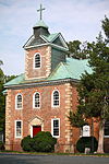 | November 12, 1969 (#69000282) | North of the junction of U.S. Route 1 and Garrisonville Rd. 38°27′53″N 77°24′11″W / 38.464722°N 77.403056°W / 38.464722; -77.403056 (Aquia Church) | Garrisonville | |
3 | Belmont |  | October 15, 1966 (#66000848) | Off U.S. Route 1 38°19′26″N 77°28′23″W / 38.323889°N 77.473056°W / 38.323889; -77.473056 (Belmont) | Falmouth | Also known as Gari Melchers Home |
4 | Bethlehem Primitive Baptist Church Cemetery | June 21, 2018 (#100002206) | 135 Chapel Green Rd. 38°17′38″N 77°21′28″W / 38.2938°N 77.3577°W / 38.2938; -77.3577 (Bethlehem Primitive Baptist Church Cemetery) | Fredericksburg vicinity | ||
5 | Carlton | 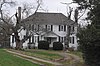 | October 3, 1973 (#73002064) | 501 Melchers Dr. 38°19′32″N 77°28′14″W / 38.325556°N 77.470556°W / 38.325556; -77.470556 (Carlton) | Falmouth | |
6 | Clearview |  | February 24, 1975 (#75002039) | Off Telegraph Rd. near U.S. Route 1 and Butler Rd. 38°19′25″N 77°27′49″W / 38.323750°N 77.463611°W / 38.323750; -77.463611 (Clearview) | Falmouth | |
7 | Conway House |  | March 8, 2004 (#04000162) | 305 King St. 38°19′19″N 77°28′07″W / 38.321806°N 77.468611°W / 38.321806; -77.468611 (Conway House) | Falmouth | |
8 | Falmouth Historic District | 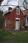 | February 26, 1970 (#70000825) | Junction of U.S. Routes 1 and 17 38°19′28″N 77°28′00″W / 38.324444°N 77.466667°W / 38.324444; -77.466667 (Falmouth Historic District) | Falmouth | |
9 | Ferry Farm Site |  | May 5, 1972 (#72001417) | East of Fredericksburg at 712 Kings Highway 38°17′36″N 77°26′55″W / 38.293333°N 77.448611°W / 38.293333; -77.448611 (Ferry Farm Site) | Fredericksburg | Same as George Washington Boyhood Home Site |
10 | Hartwood Manor | 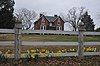 | February 1, 2006 (#05001618) | 335 Hartwood Rd. 38°25′15″N 77°34′26″W / 38.420833°N 77.573750°W / 38.420833; -77.573750 (Hartwood Manor) | Hartwood | |
11 | Hartwood Presbyterian Church |  | November 13, 1989 (#89001929) | Junction of Hartwood and Hartwood Church Rds. 38°24′07″N 77°34′01″W / 38.401944°N 77.567083°W / 38.401944; -77.567083 (Hartwood Presbyterian Church) | Hartwood | |
12 | Hunter's Ironworks | January 18, 1974 (#74002147) | West of Falmouth off U.S. Route 17 38°19′27″N 77°29′14″W / 38.324167°N 77.487222°W / 38.324167; -77.487222 (Hunter's Ironworks) | Falmouth | ||
13 | Quantico Marine Corps Base Historic District |  | March 26, 2001 (#01000260) | Marine Corps Base Quantico 38°30′08″N 77°18′21″W / 38.502222°N 77.305833°W / 38.502222; -77.305833 (Quantico Marine Corps Base Historic District) | Quantico | Extends into Prince William County |
14 | Potomac Creek Site | December 3, 1969 (#69000281) | Address Restricted | Brooke | ||
15 | Public Quarry at Government Island | 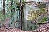 | May 30, 2007 (#03000457) | Address Restricted 38°26′54″N 77°23′00″W / 38.448333°N 77.383333°W / 38.448333; -77.383333 (Public Quarry at Government Island) | Stafford | |
16 | Redoubt No. 2 | February 14, 2006 (#06000051) | Old Fort Lane 38°23′36″N 77°21′21″W / 38.393317°N 77.355817°W / 38.393317; -77.355817 (Redoubt No. 2) | Stafford | ||
17 | Stafford Training School |  | February 5, 2013 (#12001272) | 1739 U.S. Route 1 38°24′16″N 77°25′12″W / 38.404444°N 77.420000°W / 38.404444; -77.420000 (Stafford Training School) | Stafford | |
18 | Tennessee Camp | November 12, 2008 (#08001059) | Civil War and Hill trails[6] 38°29′45″N 77°19′52″W / 38.495806°N 77.331111°W / 38.495806; -77.331111 (Tennessee Camp) | Marine Corps Base Quantico | ||
19 | Union Church and Cemetery |  | September 10, 2008 (#08000896) | Carter St. and Butler Rd. 38°19′23″N 77°27′56″W / 38.323056°N 77.465556°W / 38.323056; -77.465556 (Union Church and Cemetery) | Falmouth | |
20 | George Washington Boyhood Home Site |  | February 16, 2000 (#00000259) | 237 King's Highway 38°17′38″N 77°26′53″W / 38.293889°N 77.448056°W / 38.293889; -77.448056 (George Washington Boyhood Home Site) | Fredericksburg | |
21 | White Oak Church |  | January 3, 1991 (#90002112) | 8 Caisson Rd. 38°18′01″N 77°22′32″W / 38.300278°N 77.375694°W / 38.300278; -77.375694 (White Oak Church) | Falmouth |
See also[edit]
| Wikimedia Commons has media related to National Register of Historic Places in Stafford County, Virginia. |
- List of National Historic Landmarks in Virginia
- National Register of Historic Places listings in Virginia
- National Register of Historic Places listings in Fredericksburg, Virginia
References[edit]
^ The latitude and longitude information provided in this table was derived originally from the National Register Information System, which has been found to be fairly accurate for about 99% of listings. For about 1% of NRIS original coordinates, experience has shown that one or both coordinates are typos or otherwise extremely far off; some corrections may have been made. A more subtle problem causes many locations to be off by up to 150 yards, depending on location in the country: most NRIS coordinates were derived from tracing out latitude and longitudes from USGS topographical quadrant maps created under the North American Datum of 1927, which differs from the current, highly accurate WGS84 GPS system used by most on-line maps. Chicago is about right, but NRIS longitudes in Washington are higher by about 4.5 seconds, and are lower by about 2.0 seconds in Maine. Latitudes differ by about 1.0 second in Florida. Some locations in this table may have been corrected to current GPS standards.
^ "National Register of Historic Places: Weekly List Actions". National Park Service, United States Department of the Interior. Retrieved on November 2, 2018.
^ Numbers represent an ordering by significant words. Various colorings, defined here, differentiate National Historic Landmarks and historic districts from other NRHP buildings, structures, sites or objects.
^ National Park Service (2008-04-24). "National Register Information System". National Register of Historic Places. National Park Service..mw-parser-output cite.citationfont-style:inherit.mw-parser-output qquotes:"""""""'""'".mw-parser-output code.cs1-codecolor:inherit;background:inherit;border:inherit;padding:inherit.mw-parser-output .cs1-lock-free abackground:url("//upload.wikimedia.org/wikipedia/commons/thumb/6/65/Lock-green.svg/9px-Lock-green.svg.png")no-repeat;background-position:right .1em center.mw-parser-output .cs1-lock-limited a,.mw-parser-output .cs1-lock-registration abackground:url("//upload.wikimedia.org/wikipedia/commons/thumb/d/d6/Lock-gray-alt-2.svg/9px-Lock-gray-alt-2.svg.png")no-repeat;background-position:right .1em center.mw-parser-output .cs1-lock-subscription abackground:url("//upload.wikimedia.org/wikipedia/commons/thumb/a/aa/Lock-red-alt-2.svg/9px-Lock-red-alt-2.svg.png")no-repeat;background-position:right .1em center.mw-parser-output .cs1-subscription,.mw-parser-output .cs1-registrationcolor:#555.mw-parser-output .cs1-subscription span,.mw-parser-output .cs1-registration spanborder-bottom:1px dotted;cursor:help.mw-parser-output .cs1-hidden-errordisplay:none;font-size:100%.mw-parser-output .cs1-visible-errorfont-size:100%.mw-parser-output .cs1-subscription,.mw-parser-output .cs1-registration,.mw-parser-output .cs1-formatfont-size:95%.mw-parser-output .cs1-kern-left,.mw-parser-output .cs1-kern-wl-leftpadding-left:0.2em.mw-parser-output .cs1-kern-right,.mw-parser-output .cs1-kern-wl-rightpadding-right:0.2em
^ The eight-digit number below each date is the number assigned to each location in the National Register Information System database, which can be viewed by clicking the number.
^ Haynes, John H. National Register of Historic Places Inventory/Nomination: Tennessee Camp. National Park Service, 2005-07-22, 14.
U.S. National Register of Historic Places in Virginia | ||
|---|---|---|
| Lists by county |
|   |
| Lists by city |
| |
| Other lists |
| |
| ||
Municipalities and communities of Stafford County, Virginia, United States | ||
|---|---|---|
County seat: Stafford | ||
| CDPs |
|  |
| Unincorporated communities |
| |
| Footnotes | ‡This populated place also has portions in an adjacent county or counties | |
Categories:
- National Register of Historic Places in Stafford County, Virginia
- Lists of National Register of Historic Places in Virginia by county
(window.RLQ=window.RLQ||).push(function()mw.config.set("wgPageParseReport":"limitreport":"cputime":"0.564","walltime":"0.688","ppvisitednodes":"value":9024,"limit":1000000,"ppgeneratednodes":"value":0,"limit":1500000,"postexpandincludesize":"value":182733,"limit":2097152,"templateargumentsize":"value":12889,"limit":2097152,"expansiondepth":"value":11,"limit":40,"expensivefunctioncount":"value":0,"limit":500,"unstrip-depth":"value":1,"limit":20,"unstrip-size":"value":5918,"limit":5000000,"entityaccesscount":"value":1,"limit":400,"timingprofile":["100.00% 449.279 1 -total"," 53.24% 239.211 21 Template:NRHP_row"," 22.76% 102.240 1 Template:NRHP_header"," 17.77% 79.831 1 Template:NRISref"," 16.73% 75.163 1 Template:Cite_web"," 13.18% 59.224 48 Template:First_word"," 10.97% 49.273 21 Template:Designation/color"," 10.36% 46.541 23 Template:NRHP_color"," 9.93% 44.617 19 Template:Coord"," 8.82% 39.643 21 Template:Dts"],"scribunto":"limitreport-timeusage":"value":"0.154","limit":"10.000","limitreport-memusage":"value":3540554,"limit":52428800,"cachereport":"origin":"mw1337","timestamp":"20181112221753","ttl":1900800,"transientcontent":false);mw.config.set("wgBackendResponseTime":107,"wgHostname":"mw1323"););


