Jarocin
Jarocin | ||
|---|---|---|
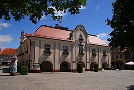
  St Martin's Church with marketplace (top) and town hall (bottom) | ||
| ||
 Jarocin | ||
| Coordinates: 51°58′N 17°30′E / 51.967°N 17.500°E / 51.967; 17.500 | ||
| Country | ||
| Voivodeship | Greater Poland | |
| County | Jarocin County | |
| Gmina | Gmina Jarocin | |
| Established | 13th century | |
| Town rights | 1257 | |
| Government | ||
| • Mayor | Adam Pawlicki | |
| Area | ||
| • Total | 14.44 km2 (5.58 sq mi) | |
| Population (2006) | ||
| • Total | 25,834 | |
| • Density | 1,800/km2 (4,600/sq mi) | |
| Time zone | UTC+1 (CET) | |
| • Summer (DST) | UTC+2 (CEST) | |
| Postal code | 63-200 | |
| Area code(s) | +48 62 | |
| Car plates | PJA | |
| Climate | Cfb | |
| Website | http://www.jarocin.pl/ | |
Jarocin ([jaˈrɔt͡ɕin]) (German: Jarotschin) is a town in central Poland with 25,700 inhabitants (1995), the administrative capital of Jarocin County. Since 1999 Jarocin has been located in Greater Poland Voivodeship, prior to that it was located in the Kalisz Voivodeship (1975–1998).
Jarocin is a historical town, having been founded and granted city rights in the 13th century.[1] The marketplace features a Ratusz town hall built between 1799 and 1804, which is now home to the Jarocin Regional Museum.
The town also became famous in the 1980s thanks to the Jarocin Festival, one of the first rock-punk music festivals of the former Warsaw Pact and in Europe. The first event was organised in 1980.[2]
Contents
1 History
2 Education
3 Twin towns
4 People
5 External links
6 References
History
The lordship of Jarocin was first mentioned in a 1257 deed issued by Duke Bolesław the Pious of Greater Poland. The town was conveniently located at the intersection of the trade routes from Wrocław to Toruń and from Poznań to Kalisz.
Jarocin was annexed by the Kingdom of Prussia in the 1793 Second Partition of Poland and administered within South Prussia. It was part of the Duchy of Warsaw from 1807–13 during the Napoleonic Wars, but was restored to Prussia afterwards. The town was included within the Grand Duchy of Posen from 1815 and the Province of Posen from 1848. It became part of the German Empire in 1871. In 1889 it was included within the newly created Jarotschin District of the Province of Posen.
Jarocin participated in the Greater Poland Uprising (1918–1919) and had the first soldiers' council in the Province of Posen. It was subsequently included in the Second Polish Republic. The West German Minister and former SS officer Waldemar Kraft was born here at Brzustow in 1898.
The town was annexed by Nazi Germany in 1939 during World War II and administered within Reichsgau Wartheland as part of the district or county (kreis) of Jarotschin. Many Polish citizens, especially Jews, were expelled and replaced with ethnic Germans from the Baltic states, Volhynia, and Bukovina. A forced labor prison operated in the vicinity from January 1941 to January 1945.[3] Following the arrival of the Red Army and the end of the war, Jarocin was made part of the People's Republic of Poland.

Radoliński Palace

St. George Church
 Play media
Video (2017)
Education
- Wielkopolska Wyższa Szkoła Humanistyczno-Ekonomiczna
Twin towns
Jarocin is twinned with:
 Libercourt, France
 Veldhoven, Netherlands
 Hatvan, Hungary
 Schlüchtern, Germany
 Oleksandriia, Ukraine
 Korkuteli, Turkey
People
Eduard Lasker (1829–1884), politician
Gustav Wegner (1903–1942), German athlete
Dame Elisabeth Schwarzkopf (1915–2006), operatic lyric soprano
Waldemar Kraft, West German Minister without Portfolio.
External links
| Wikimedia Commons has media related to Jarocin. |
- Site of Jarocin's Municipal Office
References
^ "Jarocin - Dzieje miast - Region Wielkopolska - a must see". regionwielkopolska.pl. Retrieved 26 June 2017..mw-parser-output cite.citationfont-style:inherit.mw-parser-output .citation qquotes:"""""""'""'".mw-parser-output .citation .cs1-lock-free abackground:url("//upload.wikimedia.org/wikipedia/commons/thumb/6/65/Lock-green.svg/9px-Lock-green.svg.png")no-repeat;background-position:right .1em center.mw-parser-output .citation .cs1-lock-limited a,.mw-parser-output .citation .cs1-lock-registration abackground:url("//upload.wikimedia.org/wikipedia/commons/thumb/d/d6/Lock-gray-alt-2.svg/9px-Lock-gray-alt-2.svg.png")no-repeat;background-position:right .1em center.mw-parser-output .citation .cs1-lock-subscription abackground:url("//upload.wikimedia.org/wikipedia/commons/thumb/a/aa/Lock-red-alt-2.svg/9px-Lock-red-alt-2.svg.png")no-repeat;background-position:right .1em center.mw-parser-output .cs1-subscription,.mw-parser-output .cs1-registrationcolor:#555.mw-parser-output .cs1-subscription span,.mw-parser-output .cs1-registration spanborder-bottom:1px dotted;cursor:help.mw-parser-output .cs1-ws-icon abackground:url("//upload.wikimedia.org/wikipedia/commons/thumb/4/4c/Wikisource-logo.svg/12px-Wikisource-logo.svg.png")no-repeat;background-position:right .1em center.mw-parser-output code.cs1-codecolor:inherit;background:inherit;border:inherit;padding:inherit.mw-parser-output .cs1-hidden-errordisplay:none;font-size:100%.mw-parser-output .cs1-visible-errorfont-size:100%.mw-parser-output .cs1-maintdisplay:none;color:#33aa33;margin-left:0.3em.mw-parser-output .cs1-subscription,.mw-parser-output .cs1-registration,.mw-parser-output .cs1-formatfont-size:95%.mw-parser-output .cs1-kern-left,.mw-parser-output .cs1-kern-wl-leftpadding-left:0.2em.mw-parser-output .cs1-kern-right,.mw-parser-output .cs1-kern-wl-rightpadding-right:0.2em
^ "Jarocin'17". jarocinfestiwal.pl. Retrieved 26 June 2017.
^ Zwansarbeit in NS-Staat. German Federal Archive (Bundesarchiv). [1] Accessed 9-30-11.
Coordinates: 51°58′N 17°30′E / 51.967°N 17.500°E / 51.967; 17.500


