Back Bay station
Back Bay Station Back Bay Station | |||||||||||||||||||||||||||||||||||||||||||||||
|---|---|---|---|---|---|---|---|---|---|---|---|---|---|---|---|---|---|---|---|---|---|---|---|---|---|---|---|---|---|---|---|---|---|---|---|---|---|---|---|---|---|---|---|---|---|---|---|
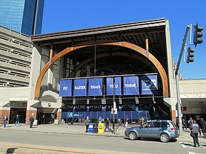 Front entrance viewed from Dartmouth Street in 2017 | |||||||||||||||||||||||||||||||||||||||||||||||
| Location | 145 Dartmouth Street Boston, Massachusetts | ||||||||||||||||||||||||||||||||||||||||||||||
| Coordinates | 42°20′50″N 71°04′32″W / 42.3473°N 71.0755°W / 42.3473; -71.0755Coordinates: 42°20′50″N 71°04′32″W / 42.3473°N 71.0755°W / 42.3473; -71.0755 | ||||||||||||||||||||||||||||||||||||||||||||||
| Owned by | Massachusetts Bay Transportation Authority | ||||||||||||||||||||||||||||||||||||||||||||||
| Line(s) | Northeast Corridor Orange Line Framingham/Worcester Line | ||||||||||||||||||||||||||||||||||||||||||||||
| Platforms | 1 island platform, 1 side platform (Northeast Corridor) 1 island platform (Orange Line) 1 island platform (Framingham/Worcester Line) | ||||||||||||||||||||||||||||||||||||||||||||||
| Tracks | 3 (Northeast Corridor) 2 (Orange Line) 2 (Framingham/Worcester Line) | ||||||||||||||||||||||||||||||||||||||||||||||
| Connections | |||||||||||||||||||||||||||||||||||||||||||||||
| Construction | |||||||||||||||||||||||||||||||||||||||||||||||
| Parking | No MBTA parking; adjacent private garage | ||||||||||||||||||||||||||||||||||||||||||||||
| Bicycle facilities | 40 spaces in "Pedal and Park" bicycle cage 30 outside spaces | ||||||||||||||||||||||||||||||||||||||||||||||
| Disabled access | Yes | ||||||||||||||||||||||||||||||||||||||||||||||
| Other information | |||||||||||||||||||||||||||||||||||||||||||||||
| Station code | BBY (Amtrak) | ||||||||||||||||||||||||||||||||||||||||||||||
| Fare zone | 1A (MBTA Commuter Rail) | ||||||||||||||||||||||||||||||||||||||||||||||
| History | |||||||||||||||||||||||||||||||||||||||||||||||
| Opened | 1880 (Columbus Avenue); 1899 (Back Bay, Trinity Place, Huntington Avenue) | ||||||||||||||||||||||||||||||||||||||||||||||
| Rebuilt | 1929; May 4, 1987 (modern station) | ||||||||||||||||||||||||||||||||||||||||||||||
| Traffic | |||||||||||||||||||||||||||||||||||||||||||||||
| Passengers (2017) | 626,003[1] | ||||||||||||||||||||||||||||||||||||||||||||||
| Passengers (2013) | 18,100 daily boardings[2] (Orange Line) | ||||||||||||||||||||||||||||||||||||||||||||||
| Passengers (2012) | 7,995 daily boardings[3] (Commuter Rail) | ||||||||||||||||||||||||||||||||||||||||||||||
| Services | |||||||||||||||||||||||||||||||||||||||||||||||
| |||||||||||||||||||||||||||||||||||||||||||||||
| |||||||||||||||||||||||||||||||||||||||||||||||
Back Bay is an intermodal passenger station in Boston, Massachusetts. It is located just south of Copley Square in Boston's Back Bay and South End neighborhoods, and serves intercity rail, commuter rail, and rapid transit lines. The present building, designed by Kallmann McKinnell & Wood, opened in 1987. It replaced the New Haven Railroad's older Back Bay station - which opened in 1928 as a replacement for an 1899-built station - as well as the New York Central's Huntington Avenue and Trinity Place stations which had been demolished in 1964.
Although South Station is Boston's primary rail hub, Back Bay maintains high traffic levels due to its location in the Back Bay neighborhood near the Prudential Center development and its access to important Northeast Corridor services. All Amtrak Acela Express and Northeast Regional trains running to and from South Station stop at Back Bay, as does the daily Lake Shore Limited long-distance train. Four MBTA Commuter Rail routes - the Providence/Stoughton Line, Franklin Line, Needham Line, and Framingham/Worcester Line - also stop at Back Bay, as do the Orange Line subway and several local MBTA Bus routes. It is the third-busiest MBTA Commuter Rail station (after North Station and South Station) and the fifth-busiest MBTA subway station.[2][3]
Contents
1 History
1.1 Night Owl crash
1.2 Air quality
1.3 Privatization and renovations
2 Station layout
3 Bus connections
4 Gallery
5 References
6 External links
History
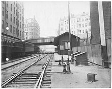
Columbus Avenue station in 1898
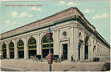
The 1899-built Back Bay station on an early postcard
The Boston and Worcester Railroad opened from downtown Boston to Newton in 1834, and to Worcester within the next several years. The Boston and Providence Railroad opened from Park Square to East Providence later that year. The two lines crossed on causeways in the Back Bay, then still used as a mill pond.[4] Around 1880, the Boston and Albany Railroad (descendant of the B&W) opened its Columbus Avenue station to serve new developments on the filled bay.[5][6][7] In 1897, the New Haven Railroad (which owned the Boston and Providence and leased the Old Colony Railroad), the New York and New England Railroad, and the Boston and Albany formed the Boston Terminal Company to consolidate their four terminals into a new union station.
Simultaneous with the construction of the resulting South Station in 1899, the New Haven also built its first Back Bay Station just east of Dartmouth Street to compete with the B&A's Columbus Avenue station. The next year, the B&A replaced Columbus Avenue station with the westbound-only Trinity Place and eastbound-only Huntington Avenue stations.[8]
The current Back Bay Station opened on May 4, 1987, as part of the Orange Line's Southwest Corridor project and was dedicated by Governor Michael Dukakis.[9] It replaced the 1899-built and 1929-rebuilt ex-New York, New Haven and Hartford Railroad station of the same name, of which some remnants can still be found at the eastern end of the present station facilities, including a carved stone embedded in the brick wall on the east side of Columbus Avenue.[10]
Part of the 1987 reconstruction includes a waiting area with a 9-foot bronze statue dedicated to civil rights and labor movement pioneer A. Philip Randolph. The area includes various posters with historical photographs and interview excerpts regarding Randolph's career in organizing the Brotherhood of Sleeping Car Porters and work with the Civil Rights Movement.
Until replaced with the CharlieCard Store at Downtown Crossing on August 13, 2012, an MBTA customer service booth for special pass users was located at Back Bay station.[11]
Night Owl crash
In 1990, a northbound commuter train running along the Providence/Stoughton Line was involved in a collision with a northbound Night Owl train. The accident, which occurred to the west of the Back Bay station, injured 453 people, although there were no fatalities.[12]
Air quality

Island platform at Back Bay; fumes in the air cause the halos around the ceiling lights
Back Bay station has suffered from poor air quality since its opening; passengers with lung conditions have been advised to avoid the station. Much of the commuter rail platforms at Back Bay are covered and enclosed, and so fumes cannot escape quickly to the outside air. A petition drive in 2000 gathered complaints about the then-"longstanding" issue.[13] Studies in 2006 in 2008 showed that "the air was many, many times below air-quality standards" due to trapped diesel exhaust and soot. An earlier study showed elevated levels of carbon monoxide, formaldehyde, particulates, and oxides of nitrogen, though it noted that there is no regulated standard to meet for indoor air quality in public spaces.
Though simple changes were made regarding scheduling, and checking to make sure train engines were running properly, in 2008 the MBTA claimed it lacked the financial resources to fully upgrade the ventilation system.[14]
In 2010, the MBTA announced that it had secured $3.0 million in federal stimulus money to improve the ventilation in the lobby.[15][16][17] While MBTA spokesman Joe Pesaturo said there was no health threat, a scientist at the Clean Air Task Force, a Boston-based nonprofit pollution research group stated, "Honestly, down on the platform it was some of the worst air quality I've measured." Additionally passengers and clerks working in the station have complained. The MBTA said then that it would complete an improved ventilation system by 2012.[18]
On October 8, 2014, Amtrak removed its customer service and ticketing agents from the station due to the persistent air quality issues. Back Bay was to be an unstaffed station "until further notice" as improvements are made.[19] Amtrak personnel returned in 2015, but Amtrak pulled them again effective October 1, 2016.[20] The station has remained unstaffed since then, though a Quik-Trak kiosk is available. However, baggage cannot be checked at the station.
A $10 million ventilation project, funded equally by MassDOT and Boston Properties, was bid in 2016 and started in early 2017. The work will improve ventilation at the platform level and add "air curtains" to prevent exhaust fumes from reaching the concourse.[21]
Privatization and renovations

Under the agreement signed in 2014, Boston Properties will renovate the station's interior and facade
In 2014, Boston Properties (which purchased the adjacent parking garage in 2010) began negotiating with the state for the right to build an air rights development atop the station and garage parcels, in exchange for managing the station and completing a $25 million renovation. Similar private management schemes were already in place at North Station and South Station, though without the real estate component.[22] An agreement was signed in late 2014, with the renovation budget increased to $32 million. In August 2015, the MBTA began paying Boston Properties a subsidy (as rents from retail spaces had been lower than expected) and agreed to fund some repairs to expansion joints not covered in the original agreement.[23]
Boston Properties filed notice with the Boston Redevelopment Authority (BRA) in December 2015, beginning the permitting process.[24] Plans for the station and development were released in March 2016. The station renovation will include restoration of the original architecture, relocation of the Orange Line entrances, expanded waiting areas in the main concourse, renovated bathrooms, improved ventilation, and new retail spaces surrounding the concourse. The station work is scheduled to begin in 2017 pending BRA approval.[25][26]
Station layout
Ground | Street Level | Exit/Entrance, waiting room, and vendors |
Platforms | Track 7 | ← Lake Shore Limited and Framingham/Worcester Line → |
Island platform, doors will open on the left, right | ||
Track 5 | ← Lake Shore Limited and Framingham/Worcester Line → | |
Southbound | ← Orange Line toward Forest Hills (Massachusetts Avenue) | |
Island platform, doors will open on the left | ||
Northbound | → Orange Line toward Oak Grove (Tufts Medical Center) → | |
Track 3 | ← Acela Express, Northeast Regional, Needham Line, Providence/Stoughton Line, and Franklin Line → | |
Island platform, doors will open on the left, right | ||
Track 1 | ← Acela Express, Northeast Regional, Needham Line, Providence/Stoughton Line, and Franklin Line → | |
Track 2 | ← Acela Express, Northeast Regional, Needham Line, Providence/Stoughton Line, and Franklin Line → | |
Side platform, doors will open on the left, right | ||

View of station from Berkeley Street overpass, looking westward. From left to right: Tracks 2, 1, 3; Orange Line tracks and train; Tracks 5 and 7.

The open-air trainshed over the Northeast Corridor platforms
There are 5 tracks serving Amtrak and commuter rail service. Tracks 2, 1, and 3 (in order south to north) serve Amtrak's Acela Express and Northeast Regional plus the MBTA's Providence/Stoughton Line, Franklin Line, and Needham Line. Tracks 5 and 7 on the Framingham/Worcester Line and the Lake Shore Limited serve westbound trains from a separate island platform.[27] Tracks 1 and 2 are considered the primary mainline tracks; the track numbering scheme used in the Boston area uses only odd numbers for additional tracks on the Track 1 side (hence Tracks 3, 5, and 7) and even numbers for tracks on the Track 2 side.[27] The Orange Line tracks and platforms lie between these two groups of mainline rail tracks.
Back Bay is fully handicapped accessible. The station has full-length high-level platforms on the three Northeast Corridor tracks, and a mini-high platform for the Worcester Line tracks. Elevators are available to access all platforms from the street-level station building.
Because Amtrak's Downeaster trains depart from North Station rather than Back Bay or South Station, Amtrak advises travelers that wish to make a connection via subway to use the Orange Line between Back Bay and North Station, as using South Station would require an additional transfer at Downtown Crossing.[28]
The main station building is located between Dartmouth Street and Clarendon Street; however, there are several additional emergency exits from the Amtrak / commuter rail platforms onto Dartmouth Street, Clarendon Street, and Columbus Avenue. The Dartmouth Street Underpass connects the Copley Place shopping mall with the main station building. The underpass was closed from March 6, 2016 to June 1, 2017 during construction at Copley Place, during which it was given some rudimentary refurbishment.[29][30]
Bus connections
Back Bay is served by three MBTA Bus routes:
10 City Point - Copley Square via Andrew Station & B.U. Medical Center
39 Back Bay – Forest Hills via Copley Square and Huntington Avenue
170 Central Square, Waltham - Dudley Square (limited early-morning service)
Gallery

This carving on Columbus Avenue is a piece from the demolished 1929 station

Station facade with John Hancock Tower behind

The main station arcade is supported by massive curved ribs

Orange Line electronic fare gates


References
^ "Amtrak Fact Sheet, Fiscal Year 2017, State of Massachusetts" (PDF). Amtrak. November 2017. Retrieved 29 December 2017..mw-parser-output cite.citationfont-style:inherit.mw-parser-output .citation qquotes:"""""""'""'".mw-parser-output .citation .cs1-lock-free abackground:url("//upload.wikimedia.org/wikipedia/commons/thumb/6/65/Lock-green.svg/9px-Lock-green.svg.png")no-repeat;background-position:right .1em center.mw-parser-output .citation .cs1-lock-limited a,.mw-parser-output .citation .cs1-lock-registration abackground:url("//upload.wikimedia.org/wikipedia/commons/thumb/d/d6/Lock-gray-alt-2.svg/9px-Lock-gray-alt-2.svg.png")no-repeat;background-position:right .1em center.mw-parser-output .citation .cs1-lock-subscription abackground:url("//upload.wikimedia.org/wikipedia/commons/thumb/a/aa/Lock-red-alt-2.svg/9px-Lock-red-alt-2.svg.png")no-repeat;background-position:right .1em center.mw-parser-output .cs1-subscription,.mw-parser-output .cs1-registrationcolor:#555.mw-parser-output .cs1-subscription span,.mw-parser-output .cs1-registration spanborder-bottom:1px dotted;cursor:help.mw-parser-output .cs1-ws-icon abackground:url("//upload.wikimedia.org/wikipedia/commons/thumb/4/4c/Wikisource-logo.svg/12px-Wikisource-logo.svg.png")no-repeat;background-position:right .1em center.mw-parser-output code.cs1-codecolor:inherit;background:inherit;border:inherit;padding:inherit.mw-parser-output .cs1-hidden-errordisplay:none;font-size:100%.mw-parser-output .cs1-visible-errorfont-size:100%.mw-parser-output .cs1-maintdisplay:none;color:#33aa33;margin-left:0.3em.mw-parser-output .cs1-subscription,.mw-parser-output .cs1-registration,.mw-parser-output .cs1-formatfont-size:95%.mw-parser-output .cs1-kern-left,.mw-parser-output .cs1-kern-wl-leftpadding-left:0.2em.mw-parser-output .cs1-kern-right,.mw-parser-output .cs1-kern-wl-rightpadding-right:0.2em
^ ab "Ridership and Service Statistics" (PDF) (14th ed.). Massachusetts Bay Transportation Authority. 2014.
^ ab Humphrey, Thomas J. (21 December 2012). "MBTA Commuter Rail Passenger Count Results" (PDF). Boston Region Metropolitan Planning Organization. Retrieved 10 August 2015.
^ Society for the Diffusion of Useful Knowledge (1842). "Boston with Charlestown and Roxbury" – via WardMaps.
^ Barrett, Richard C. (1996). Boston's Depots and Terminals. Railroad Research Publications. pp. 137–147. ISBN 1884650031.
^ Sweetser, M. F. (1880). "New Map of Boston". Boston Map Company – via Ward Maps.
^ Atlas of the City of Boston, Boston Proper. 1. G.W. Bromley and Co. 1883 – via Ward Maps.
^ Humphrey, Thomas J. & Clark, Norton D. (1985). Boston's Commuter Rail: The First 150 Years. Boston Street Railway Association. p. 22. ISBN 9780685412947.
^ "Boston-Back Bay, MA". Great American Stations. Retrieved November 20, 2012.
^ Roy, John H. Jr. (2007). A Field Guide to Southern New England Railroad Depots and Freight Houses. Branch Line Press. p. 129. ISBN 9780942147087.
^ Rocheleau, Matt (13 August 2012). "MBTA opens new CharlieCard Store inside Downtown Crossing Station". Boston Globe. Retrieved 24 September 2015.
^ "Railroad Accident Report RAR-92-01: Derailment and Collision of Amtrak Passenger Train 66 with MBTA Commuter Train 906 at Back Bay Station, Boston, Massachusetts, December 12, 1990" (PDF). National Transportation Safety Board, Washington, DC. 25 February 1992.
^ Palmer, Thomas C., Jr. (May 27, 2001). "PETITION DRIVE PUTS FOCUS ON FOUL-SMELLING T STATION COMMUTER SEEKS TO CLEAR THE AIR OF DIESEL FUMES". Boston Globe. p. B2 – via Proquest Historical Newspapers. (Subscription required (help)).
^ "Bad Air at Back Bay Too Costly to Fix, T Says". The Boston Globe. August 31, 2008. Retrieved January 14, 2011.
^ "Federal stimulus funds mean state to do something about the lung-cancer chamber known as Back Bay station". Universal Hub. Retrieved January 14, 2011.
^ "AMERICAN RECOVERY AND REINVESTMENT ACT OF 2009 MBTA PROJECT STATUS AS OF 7/1/10" (PDF). Massachusetts Department of Transportation. Retrieved January 14, 2011.
^ "American Recovery and Reinvestment Act of 2009 MBTA Implementation & Oversight" (PDF). National Council for Public-Private Partnerships. Archived from the original (PDF) on July 27, 2011. Retrieved January 14, 2011.
^ Rocheleau, Matt (October 1, 2010). "Amid Complaints, T Aims to Fix Back Bay Station's Ventilation System". The Boston Globe. Retrieved July 7, 2011.
^ "Boston, MA (BBY)". Amtrak. Archived from the original on 7 October 2014.
^ "Boston, MA (BBY)". Amtrak. Archived from the original on September 22, 2016.
^ Chesto, Jon (4 April 2016). "Relief could be coming for Back Bay commuters weary of diesel fumes". Boston Globe. Retrieved 4 April 2016.
^ Ross, Casey (18 June 2014). "Skyscraper envisioned at Back Bay station: Developer would manage T facility in return for rights". Boston Globe. Retrieved 29 March 2016.
^ Logan, Tim (10 August 2015). "Deal to privatize MBTA station debuts with shortfalls". Boston Globe. Retrieved 29 March 2016.
^ Logan, Tim (30 December 2015). "New complex proposed over Back Bay Station". Boston Globe. Retrieved 29 March 2016.
^ Logan, Tim; Chesto, Jon (29 March 2016). "Dramatic remake coming to Back Bay Station". Boston Globe. Retrieved 29 March 2016.
^ BP Hancock LLC via Boston Properties Limited Partnership (29 March 2016). "The Back Bay / South End Gateway Project – Project Notification Form". Boston Redevelopment Authority. Retrieved 29 March 2016.
^ ab Held, Patrick R. (2010). "Massachusetts Bay Colony Railroad Track Charts" (PDF). Johns Hopkins Association for Computing Machinery. Archived from the original (PDF) on October 8, 2013. Retrieved April 5, 2012.
^ "Downeaster". Amtrak. Retrieved January 24, 2017.
^ "Subway Service Alerts: Orange Line". Massachusetts Bay Transportation Authority. 24 February 2016. Archived from the original on 11 April 2016.
^ "Subway Service Alerts: Orange Line". Massachusetts Bay Transportation Authority. April 4, 2017. Archived from the original on April 20, 2017.
External links
| Wikimedia Commons has media related to Back Bay station. |
- Back Bay – Amtrak
- MBTA - Back Bay
- Boston Back Bay Amtrak Station (USA RailGuide -- Train Web)
Library of Congress. Historic American Buildings Survey. Back Bay Station, 145 Dartmouth Street, 1979.- Boston-Back Bay (BBY) (Amtrak's Great American Stations)
Dartmouth Street entrance, Columbus Avenue headhouse, and Clarendon Street busway on Google Maps Street View
Stations of the MBTA Subway | |||||||||
|---|---|---|---|---|---|---|---|---|---|
| |||||||||
| |||||||||
| |||||||||
| |||||||||
