Sariaya
| Sariaya | ||
|---|---|---|
| Municipality | ||
| Municipality of Sariaya | ||
        From L-R: Sariaya Town Plaza , Saint Francis of Assisi Parish Church, Sariaya Municipal Building, Governor Natalio Enriquez Ancestral House, Facade of Gala-Rodriguez Ancestral House, Don Lucio Rodriguez Ancestral House, Emralino-Rodriguez Ancestral House, Don Catalino Rodriguez Ancestral House | ||
| ||
Nickname(s):
| ||
Motto(s): Gilas Sariaya! (Be valiant Sariaya!) | ||
 Map of Quezon with Sariaya highlighted | ||
 Sariaya Location within the Philippines | ||
| Coordinates: 13°58′N 121°32′E / 13.97°N 121.53°E / 13.97; 121.53Coordinates: 13°58′N 121°32′E / 13.97°N 121.53°E / 13.97; 121.53 | ||
| Country | ||
| Region | Calabarzon (Region IV-A) | |
| Province | Quezon | |
| District | 2nd District | |
| Founded | October 4, 1599 | |
| Barangays | 43 (see Barangays) | |
| Government [1] | ||
| • Type | Sangguniang Bayan | |
| • Mayor | Marcelo P. Gayeta | |
| • Vice Mayor | Alexander A. Tolentino | |
| • Electorate | 77,493 voters (2016) | |
| Area [2] | ||
| • Total | 212.16 km2 (81.92 sq mi) | |
| Area rank | 13th out of 41 in Quezon | |
| Elevation | 157 m (515 ft) | |
| Population (2015 census)[3] | ||
| • Total | 148,980 | |
| • Rank | 2nd out 41 in Quezon 20 out of 1,489 Municipalities | |
| • Density | 700/km2 (1,800/sq mi) | |
| Demonym(s) | Sariayahin | |
| Time zone | UTC+8 (PST) | |
| ZIP code | 4322 | |
| PSGC | 045645000 | |
| IDD : area code | +63 (0)42 | |
| Climate type | Tropical rainforest climate | |
| Income class | 1st municipal income class | |
| Revenue (₱) | 290,454,112.97 (2016) | |
| Native languages | Tagalog | |
| Website | www.sariaya.gov.ph | |

Sariaya, officially the Municipality of Sariaya, (Tagalog: Bayan ng Sariaya), is a 1st class municipality in the province of Quezon, Philippines. According to the 2015 census, it has a population of 148,980 people.[3]
As the only Mount Banahaw town in both Quezon and Laguna Provinces that has a sea coast, the town is famous for its pristine beach resorts and nature-trekking activities that lead adventurous hikers to the peak of mythical Mount Banahaw. With more than a hundred of cultural properties and ancestral houses mostly built in Art Deco architecture within the municipality, Sariaya is considered as the Heritage Town of Quezon and the Art Deco Capital of Southern Luzon.[4] This heritage town has been branded by various cultural experts as a 'cultural gem worthy of a UNESCO designation.' The local government of the municipality with the National Commission for Culture and the Arts of the Philippines were designated to work for the heritage town's inclusion in the UNESCO World Heritage List.
Contents
1 Etymology
2 Geography
2.1 Barangays
2.2 Topography
2.3 Climate
3 Demographics
4 Economy
4.1 Income
4.2 Commerce
5 Infrastracture
5.1 Transportation
5.1.1 Bus
5.1.2 Jeepney
5.1.3 Tricycle
5.2 Hospitals
5.3 Communication
6 Festivities
7 Places of interest
7.1 Saint Francis of Assisi Parish Church
7.2 Sariaya Heritage Houses
7.3 Tumbaga Church Ruins
7.4 Sariaya Park
7.5 Resorts
8 Local Government
8.1 Government Officials
8.2 Congressional District
9 Education
10 Notable Persons
11 Sister Cities
12 References
13 External links
Etymology
The origin of the word Sariaya was allegedly came from the word Sadyaya — one of the town's numerous rivers, but words of the great ancestors and legends have it that it was named after Saria, an supposedly 'illiterate' (according to the Spanish) woman who encountered the first Spaniards in the town who were asking the name of the settlement. Saria can't understand the question as it was in Spanish, which was foreign and unknown to everyone in the area during that time. She was thus branded as illiterate by the Spanish despite being highly educated through Tagalog traditional knowledge. The woman gave her name as answer to the Spanish, assuming that they were asking her name. The Spaniards wrote "Saria" on their notebooks as the name of the settlement. And while the Spaniards were talking with each other, the natives heard them utter the words "Saria-ya". Hence, the words traveled from mouth to mouth and became a common saying until the two words were combined.
[5]
Geography
Sariaya is an inland municipality in the province of Quezon, located 126 kilometers south of the National Capital Region where the country's capital of Manila is situated and approximately 12 kilometers from the highly urbanized city of Lucena. The municipality is bordered by Tayabas City on north-east side, the city of Lucena on its southeast, the municipality of Candelaria on its west, and the town of San Juan in Batangas on its south-west. Mount Banahaw flanks it on the north and Tayabas Bay on the south side.
Barangays
Sariaya has a total land area of 24,530 hectares and composed of 43 barangays. Six (6) barangays are urban barangays located at the Poblacion, one (1) barangay is classified as sub-urban and six (6) barangays are coastal barangays.
Hereunder is the list of Barangays in Municipality of Sariaya and its land area:
| Barangay | Land Area (Ha) | Area Rank | Population (2015) | Classification |
|---|---|---|---|---|
| Antipolo | 490.60 | 27.5 | 1,866 | Rural |
| Balubal | 560.68 | 19 | 5,020 | Rural |
| Bignay 1 | 630.80 | 15 | 4,954 | Rural |
| Bignay 2 | 728.90 | 10 | 3,525 | Rural |
| Bucal | 518.63 | 23.5 | 3,206 | Rural |
| Canda | 588.71 | 18 | 3,214 | Rural |
| Castañas | 876.10 | 8 | 6,113 | Rural |
| Concepcion 1 | 827.00 | 9 | 5,197 | Rural |
| Concepcion Banahaw | 1,345.00 | 2 | 2,878 | Rural |
| Concepcion Palasan | 939.14 | 6 | 6,462 | Rural |
| Concepcion Pinagbakuran | 714.90 | 11 | 2,822 | Rural |
| Gibanga | 546.70 | 21 | 3,460 | Rural |
| Guisguis San Roque | 448.54 | 29.5 | 2,252 | Rural |
| Guisguis Talon | 530.65 | 22 | 3,929 | Rural |
| Janagdong 1 | 518.63 | 23.5 | 3,405 | Rural |
| Janagdong 2 | 672.80 | 12.5 | 2,935 | Rural |
| Limbon | 280.34 | 36 | 1,357 | Rural |
| Lutucan 1 | 392.50 | 34 | 4,602 | Rural |
| Lutucan Bata | 490.60 | 27.5 | 2,200 | Rural |
| Lutucan Malabag | 497.60 | 26 | 4,218 | Rural |
| Mamala 1 | 441.07 | 32 | 2,932 | Rural |
| Mamala 2 | 442.00 | 31 | 5,727 | Sub-Urban |
| Manggalang 1 | 1,198.43 | 3 | 6,893 | Rural |
| Manggalang Bantilan | 672.80 | 12.5 | 3,750 | Rural |
| Manggalang Kiling | 616.85 | 17 | 2,649 | Rural |
| Manggalang Tulo-Tulo | 623.80 | 16 | 3,112 | Rural |
| Montecillo | 658.79 | 14 | 4,147 | Rural |
| Morong | 434.53 | 33 | 1,833 | Rural |
| Pili | 448.54 | 29.5 | 3,949 | Rural |
| Poblacion 1 | 8.5 | 40 | 1,806 | Urban |
| Poblacion 2 | 14.5 | 39 | 1,380 | Urban |
| Poblacion 3 | 7.0 | 42 | 1,108 | Urban |
| Poblacion 4 | 16.60 | 38 | 3,386 | Urban |
| Poblacion 5 | 7.5 | 41 | 1,258 | Urban |
| Poblacion 6 | 6.0 | 43 | 1,200 | Urban |
| Sampaloc 1 | 1,037.26 | 4 | 2,608 | Rural |
| Sampaloc 2 | 1,023.24 | 5 | 6,113 | Rural |
| Sampaloc Bogon | 1,675.03 | 1 | 1,035 | Rural |
| Santo Cristo | 911.11 | 7 | 8,953 | Rural |
| Talaan Aplaya | 553.67 | 20 | 2,980 | Rural |
| Talaan Pantoc | 273.33 | 37 | 2,185 | Rural |
| Tumbaga 1 | 518.63 | 23.5 | 4,425 | Rural |
| Tumbaga 2 | 336.41 | 35 | 1,936 | Rural |
Topography

Aerial view of Sariaya's coast with Lucena City in the background.
Sariaya is situated on a flat land except for a portion on the north occupying a part of the foot of Mount Banahaw. The municipality has the highest point of elevation on 3,800 feet above sea level at Barangays Concepcion Banahaw and Sampaloc Bogon.
Climate
Sariaya falls under Type III of the PAGASA’s climatic classification system this is because it is situated on the southern portion of the province's mountain ranges characterized by seasons not very pronounced, relatively dry from December to April and wet during the rest of the year. The maximum rain periods are not very pronounced with the short dry season lasting from two to four months.[6]
| Climate data for Sariaya | |||||||||||||
|---|---|---|---|---|---|---|---|---|---|---|---|---|---|
| Month | Jan | Feb | Mar | Apr | May | Jun | Jul | Aug | Sep | Oct | Nov | Dec | Year |
| Average high °C (°F) | 28 (82) | 28 (82) | 30 (86) | 32 (90) | 32 (90) | 32 (90) | 31 (88) | 31 (88) | 31 (88) | 30 (86) | 29 (84) | 30 (86) | 30 (87) |
| Average low °C (°F) | 22 (72) | 22 (72) | 23 (73) | 24 (75) | 24 (75) | 24 (75) | 24 (75) | 24 (75) | 23 (73) | 23 (73) | 23 (73) | 23 (73) | 23 (74) |
| Average rainfall mm (inches) | 92 (3.62) | 55 (2.17) | 46 (1.81) | 62 (2.44) | 117 (4.61) | 184 (7.24) | 211 (8.31) | 211 (8.31) | 233 (9.17) | 320 (12.6) | 323 (12.72) | 263 (10.35) | 2,117 (83.35) |
| Source: World Weather Online[7] | |||||||||||||
center>Rural
Demographics
| Population census of Sariaya | ||
|---|---|---|
| Year | Pop. | ±% p.a. |
| 1903 | 12,453 | — |
| 1918 | 14,158 | +0.86% |
| 1939 | 25,736 | +2.89% |
| 1948 | 29,904 | +1.68% |
| 1960 | 42,089 | +2.89% |
| 1970 | 58,997 | +3.43% |
| 1975 | 66,847 | +2.54% |
| 1980 | 74,148 | +2.09% |
| 1990 | 91,081 | +2.08% |
| 1995 | 100,709 | +1.90% |
| 2000 | 110,561 | +2.02% |
| 2007 | 128,248 | +2.07% |
| 2010 | 138,894 | +2.94% |
| 2015 | 148,980 | +1.34% |
| Source: Philippine Statistics Authority[3][8][9][10] | ||
According to the 2015 census of population, Sariaya has a total population of 148,980 people making the second most populous area in Quezon after the City of Lucena being a highly populated area.
The Poblacion is the most populous area in Sariaya with a total population of 10,138 people according to the 2015 census, Barangay Sto. Cristo ranks second and Manggalang 1 placed in the third rank.
Economy
Income
Agriculture is one of the major sources of income in Sariaya. According to the 2016 Competitiveness Index of the National Competitiveness Council or NCC, the municipality belongs to the Top 50 most competitive municipalities in the Philippines.[11] According to the annual Audit Report of Commission on Audit (COA), Sariaya is also one of Quezon's top grossing municipalities when factoring annual income.
Here's the list of the total annual income, assets, expenses and equity of Sariaya since 2008:
| Year | Total Income (COA).[12] | Assets | Expenses | Equity |
|---|---|---|---|---|
| 2008 | ₱139.37 million | ₱141.48 million | ₱112.92 million | ₱101.17 million |
| 2009 | ₱154.89 million | ₱198.33 million | ₱141.55 million | ₱109.66 million |
| 2010 | ₱164.55 million | ₱202.63 million | ₱158.44 million | ₱101.71 million |
| 2011 | ₱183.43 million | ₱243.13 million | ₱172.08 million | ₱106.77 million |
| 2012 | ₱183.59 million | ₱237.29 | ₱181.60 million | ₱112.67 million |
| 2013 | ₱212.08 million | ₱239.29 million | ₱200.54 million | ₱117.99 million |
| 2014 | ₱243.73 million | ₱390.88 million | ₱206.07 million | ₱152.49 million |
| 2015 | ₱275.70 million | ₱467.81 million | ₱248.83 million | ₱176.53 million |
Commerce

General Luna Street, the center of trade and commerce in Sariaya

Jollibee Sariaya

Stores along the Sariaya's Business District
The trade and commerce in Sariaya is heavily concentrated at General Luna Street which is the town's central business district where majority of the town's commercial establishments are situated such as retail, supermarkets, banks, drugstores, bakeries, merchandising, grocery, hardware, fastfood chains, shopping center, convenience stores and others.
Infrastracture
Transportation
Bus

a BALGCO bus traversing the Town Proper
Traversed by the Pan-Philippine Highway, provincial buses and those plying from Metro Manila and Lucena City such as JAC Liner Inc., DLTBCO, JAM Liner, Lucena Lines, LLI Inc., BALGCO and Supreme stop for passengers at the town's designated bus stops located in Palmas Verdes Subdivision in Brgy. Concepcion 1, Sambat-Lutucan in Brgy. Sto. Cristo, Jollibee Sariaya Terminal in Brgy. Poblacion 4, and in the front of the Public Market in Brgy. Poblacion 3.
Jeepney

a Jeepney in Sariaya heading to Candelaria
There are also accessible jeepney terminals in the Town Proper. For passengers going to Lucena City, the terminal is located in front of Jollibee Sariaya Branch in General Luna Street and those bound for Candelaria and Tayabas City are served at the terminal located in front of Sariaya Public Market along General Luna Street.
Tricycle

Tricycle, the most common mode of transportation in Sariaya
Tricycles, mostly used by commuters to and from the nearby barangays, maintain several terminals in the Poblacion such as those located in Quezon Avenue, Magdami Street, and mostly near the public market.
Hospitals

Greg Hospital, one of the two hospitals located in Sariaya
There are two (2) private hospitals in Sariaya, with a dependable and well-staffed health center providing free medical and preventive services for residents of the forty-three (43) barangays of the municipality.
Greg Hospital, located at General Luna St., Brgy. Poblacion 1
Soler General Hospital, located at Mabini St., Brgy. Poblacion 6
Communication
Sariaya is served by landline and
mobile phone companies like the
General Telephone System, Inc. (GTSi) and Digitel Telecommunications (PLDT-Digitel) as the main telecommunication services providers in the municipality. Major mobile phone providers in the area includes Globe Telecom, Smart Communications, and Sun Cellular. Also, Sariaya has a cable provider which is the Sariaya Cable Network founded in 1993.
Festivities
- Agawan Festival

Bagakays
Celebrated every 15th day of May, this religious festivity pays tribute to San Isidro Labrador, the patron saint of farmers. This much-anticipated feast has close affinity with the 'Pahiyas Festival' of Lucban, Quezon. Pliant bamboo treetops and trellises (bagakay) weighed down by succulent fruits, native candies, rice cakes, and colorful rice krispies called "kiping" are deliberately pulled down on the streets by noisy merrymakers right after the afternoon procession. Festival revelers from the town's barangays, neighboring towns, and other provinces would then scramble to gather as many treats as they can snatch and carry, hence the term "Agawan."
- Town Fiesta

Santo Cristo de Burgos
On 14 September, pious devotees from far and wide pay homage to the miraculous image of the Santo Cristo de Burgos during the Feast of the Exaltation of the Cross. The Catholic feast is a day-long veneration of the replica of the Crucified Christ at the ancient Cathedral of Burgos, Spain long believed to be a gift of King Philip V of Spain in 1703 to the people of Lumangbayan in Sariaya. People from far-flung barangays flock to the Poblacion to attend the packed fiesta Masses. They also sell their farm products and handicrafts in the public market as they eagerly sample the gaudily-decorated and crowded venue for the annual "perya" (fiesta fair) for thrilling rides, occasional circus performances, and shows featuring human mutants, trained animals performing tricks, vendors peddling herbal medicines, and "peryantes," those hardy and itinerant peddlers of cheap clothing, toys, and kitchen utensils. The town's basketball tournament also holds its cherished championship game on the eve of this much-awaited day. Sometimes there are hired stage performances at the town plaza that feature some of the nation's stage and film celebrities.
Places of interest
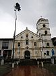
Saint Francis of Assisi Parish Church

Sariaya Church built in 1748
Saint Francis of Assisi Parish Church is a stone church built in 1748, located at Brgy. Poblacion II. Records tell that the present church is the fifth one erected by the Spanish Franciscan Friars in the history of Sariaya. In 1938, a historical marker bearing a brief history of the church was installed on its facade by the National Research and Markers Committee, precursor of the National Historical Commission of the Philippines.[13]
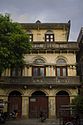
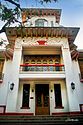
Sariaya Heritage Houses

Governor Natalio Enriquez Ancestral House

Gala-Rodriguez Ancestral House

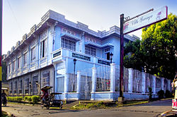
Don Catalino Rodriguez Ancestral House (Villa Sariaya)
On May 14, 2008, the National Historical Institute (NHI) unveiled markers of heritage houses for the three ancient yet still stately mansions at the heart of Sariaya town. These venerable houses are best viewed from the south, as they are silhouetted against the majestic and mystical Mount Banahaw, Quezon's long-dormant volcano. Cultural recognition was bestowed on three ancestral houses, namely: The Enriquez-Gala mansion, owned by former Tayabas (now Quezon) Gov. Natalio Enriquez and Susana Gala; the Gala-Rodriguez house of Dr. Isidro Rodriguez and Gregoria Gala, and the house of Catalino and Luisa Rodriguez also known as Villa Sariaya.[14]
Tumbaga Church Ruins

Extant wall of Tumbaga Church ruins
Remains of an early 18th-century stone church and former town site of Sariaya, located at Brgy. Tumbaga I. The settlement was inaugurated in 1703 with Father Lucas Fernandez as first parish priest and Francisco Argente as Presidente del Pueblo. The church, which measured 500 square meters, served a recorded population of 3000 parishioners. Two events led to the abandonment of the town site: the earthquake of 1743 which consequently destroyed the church's bell tower, and the Moro raids which left the town site in ruins after being razed by fire. The venerated image of Santo Cristo de Burgos is said to have been enshrined in the church before it was transferred to its present shrine in the San Francisco Church in the present-day town proper of Sariaya. The unscathed image was said have been retrieved from the burnt church after the Muslim raider attack. The church is believed to be the fourth church structure built by the Spanish Franciscan Friars in Sariaya.[15]
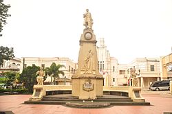
Sariaya Park

Sariaya Park
This multi-purpose park is a perfect place for recreational activities because of its pleasant and calm ambiance where kids can play at the park's playground, located at the heart of the town in front of Sariaya Church and the Town Hall at the left side. Sariaya Park is also the location where Sariaya Sports Complex is situated and usually used as the venue of different events and Basketball Leagues in the town.
Resorts
If you are going to Quezon, Sariaya is the first town in the western part of the province with a sea coast. The municipality hosts numerous beach resorts and pool resorts which offers pristine beach and recreational activities.
| Resort | Name | Location |
|---|---|---|
| Monte Vista Beach Resort | Brgy. Bignay 2 | |
 | Villa del Prado Beach Resort | Brgy. Guisguis Talon |
| Dalampasigan Beach Resort | Brgy. Guisguis Talon | |
| Paraiso Beach Resort | Brgy. Guisguis Talon | |
| Balai Loreta Beach Resort | Brgy. Talaan Aplaya | |
 | Balai Sadyaya Resort | Brgy. Balubal |
 | Oyayi Farm and Resort | Brgy. Castañas |
| Marina Azul Beach Resort | Brgy. Bignay 2 | |
| Christian's Beach Resort | Brgy. Bignay 2 | |
| Baywatch Palm Beach Club Resort | Brgy. Talaan Aplaya | |
| Beachwood Resort | Brgy. Bignay 2 | |
| Blue Bay Waters Beach Resort | Brgy. Bignay 2 | |
| Mar Del Sol Beach Resort | Brgy. Guisguis Talon | |
| La Felizza Resort | Brgy. Guisguis Talon | |
| Mapresco Beach Resort | ||
| Villa Vicenta Beach Resort | Brgy. Bignay 2 | |
| Villa Melania Beach Resort | Brgy. Guisguis Talon | |
| Safari Beach Resort | Brgy. Guisguis Talon | |
 Villa Trenta Eddy WoW Pool Farm Resort | Villa Trenta / Eddy WoW Pool Farm Resort | Brgy. Pili (Brgy. Bucal) |
| Floreddy's Farm Resort | Brgy. Pili |
Pool Resorts
- Villa Leandro Resort
- Lucky D Resort
- Primavera Resort
- Lynelle's Lagoon Resort
- Ada's Resort and Spa
- BLT Farmville Resort
- Villa Trenta / Eddy WoW Pool Farm Resort
- Floreddy's Farm Resort
Beach Resorts with Boat Rides to Coral Reefs
- Triple J Beach Resort (Brgy. Guis-Guis Talon)
- M.Y. Beach Resort (Brgy. Guis-Guis Talon)
Local Government
Government Officials

Sariaya Municipal Building
The 2016 local elections in Sariaya was held on May 9, 2016 and some members of the municipal government was replaced, including the mayor, vice mayor and other members of the municipal council. Elected officials for the 2016-2019 term are:
| Position | Name |
|---|---|
Mayor | Marcelo P. Gayeta |
Vice Mayor | Alexander A. Tolentino |
Councilors | Teoderico C. dela Peña |
| Leonardo S. dela Roca | |
| Aristeo M. Ilao | |
| Daisy V. Quiminiano | |
| Ofelia C. Villapando | |
| Julio C. de Leon | |
| Jefferson E. Albis | |
| Demia P. Maghirang |
Congressional District
The Municipality of Sariaya belongs to the 2nd District of Quezon, located in the western part of the province together with the municipalities of San Antonio, Dolores, Tiaong, Candelaria and the City of Lucena. The Second District is the most populous in the four districts in the Province of Quezon with a total population of 694,732 people according to the 2015 census of population and almost ⅓ of the province's total population.
| City/Municipality | District | Income Class | Land Area | Population (2015) |
|---|---|---|---|---|
| Lucena City | 2nd | Highly Urbanized | 80.21 km² (30.97 sq mi) | 266,248 |
| Candelaria | 2nd | 1st class | 129.10 km² (49.85 sq mi) | 117,434 |
| Dolores | 2nd | 4th class | 60.35 km² (23.30 sq mi) | 28,891 |
| San Antonio | 2nd | 3rd class | 172.93 km² (66.77 sq mi) | 33,467 |
 Sariaya Sariaya | 2nd | 1st class | 245.3 km² (94.7 sq mi) | 148,980 |
 Tiaong Tiaong | 2nd | 1st class | 168.38 km² (65.01 sq mi) | 99,712 |
Education

Colegio de Sto. Cristo de Burgos

Sariaya Institute

St. Joseph's Academy

Sariaya East Central Main Elementary School
| Level | School |
|---|---|
Tertiary | Computer Systems Technological College Inc. |
| Colegio de Santo Cristo de Burgos | |
Secondary | Sariaya Institute (private non-sectarian) |
| St. Joseph's Academy of Sariaya, Quezon (private sectarian) | |
| St. Francis High School (private sectarian) | |
| Lutucan National High School (public) | |
| Canda National High School (public) | |
| Sariaya National High School (public) | |
| Pili National High School (public) | |
| Janagdong National High School (public) | |
Primary | Sariaya East Central Main Elementary School |
| Manuel L. Quezon Elementary School | |
| Jose Rizal Elementary School | |
| Mamala Elementary School | |
| Balubal Elementary School | |
| Sampaloc Elementary School | |
| Concepcion Elementary School | |
| Governor Natalio and Susana Enriquez Elementary School | |
| Pantoc Elementary School | |
| Talaan Elementary School | |
| Morong Elementary School | |
| Manggalang Elementary School | |
| Concepcion Ibaba Elementary School | |
| Concepcion Pinagbakuran Elementary School | |
| Lutucan Bata Elementary School | |
| Concepcion Banahaw Elementary School | |
| Tulo-Tulo Elementary School | |
| Castañas Elementary School | |
| Lutucan Adventist Elementary School | |
| Sariaya Conservative Baptist Christian School Inc. | |
| Holy Spirit Learning Center | |
| St. Therese of the Child Jesus Learning Center |
Notable Persons
Leo Austria — former professional basketball player and the head coach of San Miguel Beermen of the Philippine Basketball Association.
Maximo Rodriguez — twice Sariaya Municipal President (Mayor) from 1906-1907 and 1914-1916 and twice Tayabas (Quezon) Provincial Governor from 1916-1922 and 1933-1937. He also became the principal sponsor of former Philippine president Manuel L. Quezon and Aurora Aragon at their Hong Kong wedding and he was also the instrument in the peaceful surrender of the dreaded Kapitan Kulas and became the Chairman-General Manager of the National Coconut Corporation (NACOCO), the fore runner of the Philippine Coconut Authority. He established the Maximo Rodriguez Solid Laboratory in Sariaya.
Braulio de Villa — twice Sariaya Town Gobernadorcillo (Mayor) in 1889 and 1892 to 1894, and later became the Provincial Governor of Batangas, his home province.
Natalio Enriquez – Sariaya Municipal President (Mayor) from 1938 to 1940 and later became the Provincial Governor of Tayabas (Quezon Province) from 1941 to 1945.
Jovencio de Villa – became the Provincial Governor of Tayabas Province (Quezon Province) during the Japanese Occupation period.
Roberto P. Racelis – was elected as Provincial Vice Governor of Quezon Province thrice but became Governor (by Operation of Law) from August 8, 1995 to July 25, 1996, and from April 4, 1998 to June 30, 1998.
Don John L. Montalbo – is known for discovering the "Talon sa Bahanaw" on August 24, 1996.
Sister Cities
Sariaya has sister city relationship with the foreign community of:
 Santa Clarita, California, United States, since 2003[17][18]
References
^ "Municipality". Quezon City, Philippines: Department of the Interior and Local Government. Retrieved 31 May 2013..mw-parser-output cite.citationfont-style:inherit.mw-parser-output qquotes:"""""""'""'".mw-parser-output code.cs1-codecolor:inherit;background:inherit;border:inherit;padding:inherit.mw-parser-output .cs1-lock-free abackground:url("//upload.wikimedia.org/wikipedia/commons/thumb/6/65/Lock-green.svg/9px-Lock-green.svg.png")no-repeat;background-position:right .1em center.mw-parser-output .cs1-lock-limited a,.mw-parser-output .cs1-lock-registration abackground:url("//upload.wikimedia.org/wikipedia/commons/thumb/d/d6/Lock-gray-alt-2.svg/9px-Lock-gray-alt-2.svg.png")no-repeat;background-position:right .1em center.mw-parser-output .cs1-lock-subscription abackground:url("//upload.wikimedia.org/wikipedia/commons/thumb/a/aa/Lock-red-alt-2.svg/9px-Lock-red-alt-2.svg.png")no-repeat;background-position:right .1em center.mw-parser-output .cs1-subscription,.mw-parser-output .cs1-registrationcolor:#555.mw-parser-output .cs1-subscription span,.mw-parser-output .cs1-registration spanborder-bottom:1px dotted;cursor:help.mw-parser-output .cs1-hidden-errordisplay:none;font-size:100%.mw-parser-output .cs1-visible-errorfont-size:100%.mw-parser-output .cs1-subscription,.mw-parser-output .cs1-registration,.mw-parser-output .cs1-formatfont-size:95%.mw-parser-output .cs1-kern-left,.mw-parser-output .cs1-kern-wl-leftpadding-left:0.2em.mw-parser-output .cs1-kern-right,.mw-parser-output .cs1-kern-wl-rightpadding-right:0.2em
^
"Province: Quezon". PSGC Interactive. Quezon City, Philippines: Philippine Statistics Authority. Retrieved 12 November 2016.
^ abc
Census of Population (2015). "Region IV-A (Calabarzon)". Total Population by Province, City, Municipality and Barangay. PSA. Retrieved 20 June 2016.
^ "Sariaya, Quezon itinuturing na Art Deco Capital of Southern Luzon dahil sa heritage houses". GMA News.
^ "Sariaya, Quezon (History, People, Places, About, Facts)". WowQuezon. Retrieved 26 April 2017.
^ "Climate of Sariaya". Mount Banahaw.
^
"Average High/Low Temperature for Sariaya, Quezon, Philippines". World Weather Online. Retrieved 2 July 2016.
^
Census of Population and Housing (2010). "Region IV-A (Calabarzon)". Total Population by Province, City, Municipality and Barangay. NSO. Retrieved 29 June 2016.
^
Censuses of Population (1903–2007). "Region IV-A (Calabarzon)". Table 1. Population Enumerated in Various Censuses by Province/Highly Urbanized City: 1903 to 2007. NSO.
^
"Province of Quezon". Municipality Population Data. Local Water Utilities Administration Research Division. Retrieved 17 December 2016.
^ "Competitiveness Index". National Competitiveness Council.
^ "2014 COA Annual Financial Report for Local Government Unit". "Commission on Audit.
^ "Sariaya Church". Waypoints".
^ Mallari Jr., Delfin. "History lives in Sariaya mansions". Philippine daily Inquirer. Archived from the original on December 29, 2013. Retrieved May 14, 2013.
^ San Jose-Valdoria, Nancy (November–December 2001). "Tumbaga: Unang "Pueblo", 1703-1743". Sariaya Community Magazine. 2 (7): 20–22.
^ "Elected Officials of Sariaya". iVotePH.
^ "Santa Clarita, California Sister Cities" at Santa Clarita Sister Cities (SCVIP) website.
^ "Sariaya, Philippines & Santa Clarita, California". Washington, DC: Sister Cities International. Retrieved 2015-02-04.
External links
| Wikimedia Commons has media related to Sariaya, Quezon. |
- Official website
Sariaya on Facebook
Sariaya on Instagram- Local Governance Performance Management System
Places adjacent to Sariaya | ||||||||||
|---|---|---|---|---|---|---|---|---|---|---|
| ||||||||||
Lucena (capital) | |
| Municipalities |
|
| Component city |
|
| Highly urbanized city |
|
