Oslofjord

Map of Oslofjord
The Oslofjord (Norwegian: Oslofjorden, Urban East Norwegian: [²ʊʂlʊˌfjuːɳ]; English: Oslo Fjord[1][2]) is an inlet in the south-east of Norway, stretching from an imaginary line between the Torbjørnskjær and Færder lighthouses and down to Langesund in the south to Oslo in the north. It is part of the Skagerrak strait, connecting the North Sea and the Kattegat sea area, which leads to the Baltic Sea. The Oslofjord is not a fjord in the geological sense — in Norwegian the term fjord can refer to a wide range of waterways. The bay is divided into the inner (indre) and outer (ytre) Oslofjord at the point of the 17 by 1 kilometre (10.56 by 0.62 mi) Drøbak Sound.

Summer houses in the Oslofjord
Contents
1 The name
2 Geography
2.1 Climate
3 History
4 Second World War
5 Demographics
6 Recreation
7 Image gallery
8 References
The name
In the period 1624–1925 the name of the fjord was Kristianiafjorden (or Christianiafjorden), since Christiania was the name of the capital in this period. The old Norse name of the fjord was Fold, giving names to the counties of Vestfold ('the district west of Fold') and Østfold ('the district east of Fold') — and also the district Follo.
Geography
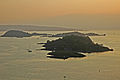
Each of the islands in the innermost part of the fjord has its own identity and distinguishing history. Among them are Hovedøya, Lindøya, Nakholmen, Bleikøya, Gressholmen, and Langøyene. These islands can be reached with the Oslo-boats from Aker Brygge. Hovedøya contains monastery ruins, Gressholmen for its rabbits, Nakholmen, Bleikøya, Lindøya for their cosy cabins at the water’s edge, and finally Langøyene for its camping possibilities and beach.[citation needed]
The inner part of the Oslofjord has steep and forest covered hill slopes down towards the fjord.[citation needed]
Climate
The Oslofjord has Norway’s highest all year temperature: 7.5 degrees Celsius. February is the coldest month in the fjord with -1.3 degrees Celsius, while July normally has 17.2 degrees Celsius. The islands in the middle of the fjord are among Norway’s warmest with high summer temperatures and moderate winters. Oslofjord’s relatively high temperatures enable various flora to flourish.[citation needed]
History
The oldest settlements in the area surrounding the Oslofjord date from the Stone Age and the Bronze Age. It was here on the eastern and western shores that three of the best preserved Viking ships were unearthed. In historical times, this bay was known by the current name of the region, Viken (the bay).[citation needed]
Oslofjord has been an important body of water strategically due to its proximity to Oslo. During WWII, there were German installations at several points on its coastline. One installation in Hovedøya held 1,100 Wehrmacht soldiers and later women deemed Nazi collaborators at the National Internment Camp for Women in Hovedøya.[citation needed]
Norwegian painter Edvard Munch had a cottage and studio in Åsgårdstrand on the fjord and the Oslofjord appears in several of his paintings, including The Scream and Girls on the Pier.[citation needed]
Second World War

German cruiser Blücher
The fjord was the scene of a key event in the German invasion of Norway in April 1940, the Battle of Drøbak Sound. The invasion included a planned landing of 1,000 troops transported by ship to Oslo. Colonel Eriksen, Commander of the Oscarsborg fortress near Drøbak, mainly maintained for historical purposes, sank the German heavy cruiser Blücher in the Drøbak narrows.[citation needed]
The fortress's resistance blocked the route to Oslo, thus delaying the rest of the group long enough for the royal family, government, parliament, and national treasury to be evacuated. The result was that Norway never surrendered to the Germans, leaving the Quisling government illegitimate and permitting Norway to participate as an ally in the war, rather than as a conquered nation.[citation needed]

False-colour image of middle parts of Oslofjorden. North is to the left
Demographics
The entire population situated around the Oslofjord including Oslo is about 1.96 million, and the total population of all the counties situated around the fjord is approximately 2.2 million.[citation needed]
More than 40% of Norway’s population resides under 45 minutes of driving from the Oslofjord. The Oslofjord has Norway’s busiest traffic of ferries and cargo boats.[citation needed]
Although the Oslofjord contains hundreds of populated islands, most of the population of the fjord resides on the mainland.[citation needed]
Recreation
In the summer there are boats of all sizes on the fjord, and it is possible to go kayaking, canoeing, fishing, and sailing.[citation needed]
The Oslofjord is one of the nine venues of the Class 1 World Powerboat Championship.[citation needed]
Image gallery
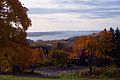
Oslofjord seen from Holmenkollen.
Oslofjord seen from Ekeberg, in Oslo.

Boats in the fjord mid-2006.

Oslofjord from Oslo-Copenhagen ferry.


| Wikimedia Commons has media related to Oslofjorden. |
Coordinates: 59°21′N 10°35′E / 59.350°N 10.583°E / 59.350; 10.583
References
^ de Jong, Folkert (2007). Marine Eutrophication in Perspective: On the Relevance of Ecology for Environmental Policy. Berlin: Springer. p. 53..mw-parser-output cite.citationfont-style:inherit.mw-parser-output .citation qquotes:"""""""'""'".mw-parser-output .citation .cs1-lock-free abackground:url("//upload.wikimedia.org/wikipedia/commons/thumb/6/65/Lock-green.svg/9px-Lock-green.svg.png")no-repeat;background-position:right .1em center.mw-parser-output .citation .cs1-lock-limited a,.mw-parser-output .citation .cs1-lock-registration abackground:url("//upload.wikimedia.org/wikipedia/commons/thumb/d/d6/Lock-gray-alt-2.svg/9px-Lock-gray-alt-2.svg.png")no-repeat;background-position:right .1em center.mw-parser-output .citation .cs1-lock-subscription abackground:url("//upload.wikimedia.org/wikipedia/commons/thumb/a/aa/Lock-red-alt-2.svg/9px-Lock-red-alt-2.svg.png")no-repeat;background-position:right .1em center.mw-parser-output .cs1-subscription,.mw-parser-output .cs1-registrationcolor:#555.mw-parser-output .cs1-subscription span,.mw-parser-output .cs1-registration spanborder-bottom:1px dotted;cursor:help.mw-parser-output .cs1-ws-icon abackground:url("//upload.wikimedia.org/wikipedia/commons/thumb/4/4c/Wikisource-logo.svg/12px-Wikisource-logo.svg.png")no-repeat;background-position:right .1em center.mw-parser-output code.cs1-codecolor:inherit;background:inherit;border:inherit;padding:inherit.mw-parser-output .cs1-hidden-errordisplay:none;font-size:100%.mw-parser-output .cs1-visible-errorfont-size:100%.mw-parser-output .cs1-maintdisplay:none;color:#33aa33;margin-left:0.3em.mw-parser-output .cs1-subscription,.mw-parser-output .cs1-registration,.mw-parser-output .cs1-formatfont-size:95%.mw-parser-output .cs1-kern-left,.mw-parser-output .cs1-kern-wl-leftpadding-left:0.2em.mw-parser-output .cs1-kern-right,.mw-parser-output .cs1-kern-wl-rightpadding-right:0.2em
^ Braarud, Trygve (1945). A Phytoplankton Survey of the Polluted Waters of Inner Oslo Fjord. Oslo: I kommisjon hos Jacob Dybwad. p. 11ff.