File:UK motorways map (thick lines).svg
File:UK motorways map (thick lines).svg
Jump to navigation
Jump to search
- File
- File history
- File usage
- Metadata
Size of this PNG preview of this SVG file: 486 × 599 pixels. Other resolutions: 195 × 240 pixels | 389 × 480 pixels | 487 × 600 pixels | 623 × 768 pixels | 831 × 1,024 pixels | 1,038 × 1,279 pixels.
Original file (SVG file, nominally 1,038 × 1,279 pixels, file size: 456 KB)
| This is a file from the Wikimedia Commons. Information from its description page there is shown below. Commons is a freely licensed media file repository. You can help. |
Summary
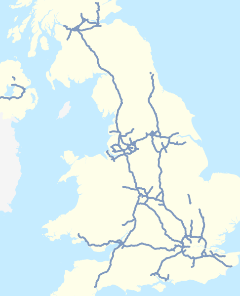
| DescriptionUK motorways map (thick lines).svg | English: Map of the motorways of the United Kingdom in 2016 (including motorways under construction, not separately identified). Equirectangular map projection on WGS 84 datum. |
| Date | 25 February 2016 |
| Source | This file was derived from:
|
| Author |
|
| Other versions |
|
 A38 UK road map.svg
 Stirling UK location map.svg
 Glasgow UK location map.svg
 Scottish council areas 2011.svg
References
Information about motorways under construction:
Forth Replacement Crossing maps, Transport Scotland, accessed 2016-02-24
M8 M73 M74 Improvements map, Transport Scotland, accessed 2016-02-24
A1 Leeming to Barton Improvement, Highways England, accessed 2016-02-24
Licensing
| Contains map data © OpenStreetMap contributors, made available under the terms of the Open Database License (ODbL). The ODbL does not require any particular license for maps produced from ODbL data; map tiles produced by the OpenStreetMap foundation are licensed under the CC-BY-SA-2.0 licence, but maps produced by other people may be subject to other licences.Open Database LicenseODbLhttp://opendatacommons.org/licenses/odbl/1.0/true |
| This file is licensed under the Creative Commons Attribution-Share Alike 4.0 International license. | |
| Attribution: Nilfanion and Dr Greg. © OpenStreetMap contributors. Contains Ordnance Survey data © Crown copyright and database right 2010. | ||
https://creativecommons.org/licenses/by-sa/4.0 |
File history
Click on a date/time to view the file as it appeared at that time.
| Date/Time | Thumbnail | Dimensions | User | Comment | |
|---|---|---|---|---|---|
| current | 17:27, 25 February 2016 |  | 1,038 × 1,279 (456 KB) | Dr Greg | User created page with UploadWizard |
File usage
The following pages on the English Wikipedia link to this file (pages on other projects are not listed):
- A1(M) motorway
- A167 road
- A18 road (England)
- A194 road
- A308(M) motorway
- A329(M) motorway
- A38(M) motorway
- A3 road
- A404(M) motorway
- A41 road
- A48(M) motorway
- A601(M) motorway
- A6144(M) motorway
- A627(M) motorway
- A66 road
- A74(M) and M74 motorways
- A8(M) motorway
- A8(M) motorway (Northern Ireland)
- A823(M) motorway
- Belfast Urban Motorway
- East Cross Route
- Highways England
- Leeds Inner Ring Road
- List of roads and highways
- Longbridge Interchange
- M10 motorway (Great Britain)
- M11 motorway
- M12 motorway
- M12 motorway (Great Britain)
- M15 motorway (Great Britain)
- M16 motorway
- M180 motorway
- M181 motorway
- M18 motorway (Great Britain)
- M1 motorway
- M1 motorway (Northern Ireland)
- M20 motorway
- M22 motorway (Northern Ireland)
- M23 motorway
- M25 motorway
- M26 motorway
- M271 motorway
- M275 motorway
- M27 motorway
- M2 motorway (Great Britain)
- M2 motorway (Northern Ireland)
- M31 motorway
- M32 motorway
- M3 motorway (Great Britain)
- M3 motorway (Northern Ireland)
- M40 motorway
- M42 motorway
- M45 motorway
- M48 motorway
- M49 motorway
- M4 bus lane
- M4 motorway
- M4 relief road
- M50 motorway (Great Britain)
- M53 motorway
- M54 motorway
- M55 motorway
- M56 motorway
- M57 motorway
- M58 motorway
- M5 motorway
- M5 motorway (Northern Ireland)
- M602 motorway
- M606 motorway
- M60 motorway
- M61 motorway
- M621 motorway
- M62 motorway
- M63 motorway
- M64 motorway
- M65 motorway
- M66 motorway
- M67 motorway
- M69 motorway
- M6 Toll
- M6 motorway
- M73 motorway
- M77 motorway
- M80 motorway
- M876 motorway
- M898 motorway
- M8 motorway (Scotland)
- M90 motorway
- M9 motorway (Scotland)
- Mancunian Way
- Preston By-pass
- Scotch Corner
- Smart motorway
- West Cross Route
- Westway (London)
- User:Regan123/sandbox3
- User:Sceptre/workspace/M1 motorway
- Template:Motorways in the United Kingdom
Metadata
(window.RLQ=window.RLQ||).push(function()mw.config.set("wgBackendResponseTime":234,"wgHostname":"mw1264"););
.svg "Creative")