Nesslau

 Clash Royale CLAN TAG#URR8PPP
| Nesslau | |
|---|---|
 Nesslau village | |
 Nesslau | |
Location of Nesslau 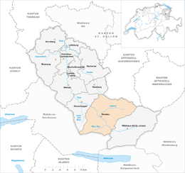 Show map of Switzerland  Nesslau Nesslau (Canton of St. Gallen) Show map of Canton of St. Gallen | |
| Coordinates: 47°13′N 9°12′E / 47.217°N 9.200°E / 47.217; 9.200Coordinates: 47°13′N 9°12′E / 47.217°N 9.200°E / 47.217; 9.200 | |
| Country | Switzerland |
| Canton | St. Gallen |
| District | Toggenburg |
| Government | |
| • Mayor | Rolf Huber |
| Area[1] | |
| • Total | 92.7 km2 (35.8 sq mi) |
| Population (Dec 2017[2]) | |
| • Total | 3,599 |
| • Density | 39/km2 (100/sq mi) |
| Postal code | 9650 / 9651 / 9652 / 9643 / 9655 |
| SFOS number | 3360 |
| Surrounded by | Alt Sankt Johann, Amden, Ebnat-Kappel, Hemberg, Hundwil (AR), Schänis, Urnäsch (AR), Wildhaus |
| Website | www.nesslau-krummenau.ch SFSO statistics |
Nesslau is a municipality in the Toggenburg district of the canton of St. Gallen, Switzerland.
The current municipality was formed in 2013 and includes the villages of Nesslau, Krummenau and Stein.
Contents
1 History
2 Geography
3 Historic Population
4 Sights
5 Heritage sites of national significance
6 References
7 External links
History
The area was incorporated into the domains of the counts of Toggenburg and the Abbey of St. Gall from the 12th century.
Nesslau is first mentioned in 1178 as Mezellouo. In 1261 it was mentioned as Nesselove and ze dem Wassere. In 912 the hamlet of Lutenwil was mentioned as Lutherraheimara.[3] Krummenau is first mentioned in 1266 as Crumbenowe.[4]
Sidwald developed into a regional cattle market from the 16th century.
After a series of fires in the benedictine abbey of St. John's in the upper Toggenburg, the monastery was moved to Neu St. Johann near Sidwald in 1626.
From 1831 to 2002, Nesslau was the administrative center of the constituency of Obertoggenburg.
The railway connecting Ebnat-Kappel to Nesslau-Neu St. Johann was opened in 1912, resulting in development of tourism in the region.
The former municipality of Nesslau was merged with Krummenau into Nesslau-Krummenau in 2005. A further merger with Stein in 2013 resulted in the current municipality of Nesslau.[5][6]
The pre-2005 Nesslau had a different Community Identification Number (SFOS) (3355) and was smaller than the current municipality of Nesslau.
Geography

Fir tree and hillside near Stein
The new municipality of Nesslau has an area of 92.7 km2 (35.79 sq mi).[1]
Nesslau-Krummenau had an area, as of 2006[update], of 80.4 km2 (31.0 sq mi). Of this area, 53.8% is used for agricultural purposes, while 36.5% is forested. Of the rest of the land, 3.2% is settled (buildings or roads) and the remainder (6.6%) is non-productive (rivers or lakes).[7] The former municipality was located on both sides of the Thur river between the Speer and Stockberg and from the Silberplatten in the Säntis range over the Schwägalp Pass to Mistelegg. After the merger in 2005 it was, in terms of land area, the third largest municipality in the canton.[8] It consists of the villages of Nesslau, Krummenau, Neu St. Johann, Dorf and Ennetbühl as well as the hamlets of Lutenwil, Krümmenschwil, Büel, Schneit, Laad, Schlatt (until the merger an exclave of Nesslau in Krummenau), Aemelsberg and Beiereggbis.
Stein had an area, as of 2006[update], of 12.3 km2 (4.7 sq mi). Of this area, 57.3% is used for agricultural purposes, while 37.3% is forested. Of the rest of the land, 2.2% is settled (buildings or roads) and the remainder (3.3%) is non-productive (rivers or lakes).[7]
Historic Population
The historical population is given in the following chart:[9]

Sights

Reformed church
The village of Stein has a pair of notable churches. The Reformed church was built in 1497 and renovated in 1929. The north tower has a gabled roof. The Catholic church of St. Jacob was built in 1927-28, but the Rococo pulpit dates from 1770.[10]
Heritage sites of national significance

The former Benedictine Abbey of Neu St. Johann
The house at Sidwaldstrasse 6 and the former Benedictine Abbey of Neu St. Johann are listed as Swiss heritage sites of national significance.[11] The village of Ennetbühl is designated as part of the Inventory of Swiss Heritage Sites.[12]
References
^ ab Arealstatistik Standard - Gemeindedaten nach 4 Hauptbereichen
^ Swiss Federal Statistical Office - STAT-TAB, online database – Ständige und nichtständige Wohnbevölkerung nach institutionellen Gliederungen, Geburtsort und Staatsangehörigkeit (in German) accessed 17 September 2018
^ Nesslau in German, French and Italian in the online Historical Dictionary of Switzerland.
^ Krummenau in German, French and Italian in the online Historical Dictionary of Switzerland.
^ Amtliches Gemeindeverzeichnis der Schweiz published by the Swiss Federal Statistical Office (in German) accessed 14 January 2010
^ Amtliches Gemeindeverzeichnis der Schweiz published by the Swiss Federal Statistical Office (in German) accessed 2 January 2013
^ ab Swiss Federal Statistical Office accessed 6 January 2013
^ Nesslau-Krummenau in German, French and Italian in the online Historical Dictionary of Switzerland.
^ Federal Statistical Office STAT-TAB Bevölkerungsentwicklung nach Region, 1850-2000 Archived 17 March 2012 at the Wayback Machine. (in German) accessed 29 January 2011
^ Flüeler (1982). Kulturführer Schweiz. Zurich, CH: Ex Libris Verlag AG. p. 369..mw-parser-output cite.citationfont-style:inherit.mw-parser-output qquotes:"""""""'""'".mw-parser-output code.cs1-codecolor:inherit;background:inherit;border:inherit;padding:inherit.mw-parser-output .cs1-lock-free abackground:url("//upload.wikimedia.org/wikipedia/commons/thumb/6/65/Lock-green.svg/9px-Lock-green.svg.png")no-repeat;background-position:right .1em center.mw-parser-output .cs1-lock-limited a,.mw-parser-output .cs1-lock-registration abackground:url("//upload.wikimedia.org/wikipedia/commons/thumb/d/d6/Lock-gray-alt-2.svg/9px-Lock-gray-alt-2.svg.png")no-repeat;background-position:right .1em center.mw-parser-output .cs1-lock-subscription abackground:url("//upload.wikimedia.org/wikipedia/commons/thumb/a/aa/Lock-red-alt-2.svg/9px-Lock-red-alt-2.svg.png")no-repeat;background-position:right .1em center.mw-parser-output .cs1-subscription,.mw-parser-output .cs1-registrationcolor:#555.mw-parser-output .cs1-subscription span,.mw-parser-output .cs1-registration spanborder-bottom:1px dotted;cursor:help.mw-parser-output .cs1-hidden-errordisplay:none;font-size:100%.mw-parser-output .cs1-visible-errorfont-size:100%.mw-parser-output .cs1-subscription,.mw-parser-output .cs1-registration,.mw-parser-output .cs1-formatfont-size:95%.mw-parser-output .cs1-kern-left,.mw-parser-output .cs1-kern-wl-leftpadding-left:0.2em.mw-parser-output .cs1-kern-right,.mw-parser-output .cs1-kern-wl-rightpadding-right:0.2em
^ Swiss inventory of cultural property of national and regional significance Archived 1 May 2009 at the Wayback Machine. 21.11.2008 version, (in German) accessed 15-Jan-2010
^ ISOS site accessed 15-Jan-2010
External links
| Wikimedia Commons has media related to Nesslau SG. |
Official website (in German)
Krummenau in German, French and Italian in the online Historical Dictionary of Switzerland.
Nesslau in German, French and Italian in the online Historical Dictionary of Switzerland.
Stein (SG) in German, French and Italian in the online Historical Dictionary of Switzerland.
Nesslau-Krummenau in German, French and Italian in the online Historical Dictionary of Switzerland.
Municipalities in the Wahlkreis of Toggenburg, Switzerland | ||
|---|---|---|
| ||