Newfield, New Jersey

 Clash Royale CLAN TAG#URR8PPP
 | Newfield, New Jersey | |
|---|---|
Borough | |
Borough of Newfield | |
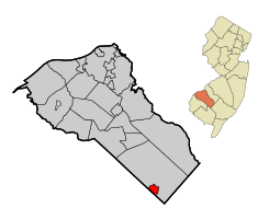 Map of Newfield highlighted within Gloucester County. Inset: Location of Gloucester County in New Jersey. | |
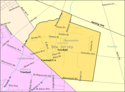 Census Bureau map of Newfield, New Jersey | |
Coordinates: 39°33′03″N 75°00′37″W / 39.550847°N 75.010258°W / 39.550847; -75.010258Coordinates: 39°33′03″N 75°00′37″W / 39.550847°N 75.010258°W / 39.550847; -75.010258[1][2] | |
| Country | |
| State | |
| County | |
| Incorporated | March 8, 1924 |
| Government[6] | |
| • Type | Borough |
| • Body | Borough Council |
| • Mayor | Donald Sullivan (R, term ends December 31, 2018)[3][4] |
| • Municipal clerk | Toni Van Camp[5] |
| Area[1] | |
| • Total | 1.706 sq mi (4.418 km2) |
| • Land | 1.703 sq mi (4.410 km2) |
| • Water | 0.003 sq mi (0.008 km2) 0.18% |
| Area rank | 430th of 566 in state 19th of 24 in county[1] |
| Elevation[7] | 118 ft (36 m) |
| Population (2010 Census)[8][9][10] | |
| • Total | 1,553 |
| • Estimate (2016)[11] | 1,567 |
| • Rank | 512th of 566 in state 24th of 24 in county[12] |
| • Density | 912.0/sq mi (352.1/km2) |
| • Density rank | 397th of 566 in state 15th of 24 in county[12] |
| Time zone | UTC-5 (Eastern (EST)) |
| • Summer (DST) | UTC-4 (Eastern (EDT)) |
| ZIP code | 08344[13][14] |
| Area code(s) | 856[15] |
| FIPS code | 3401551390[16][17] |
GNIS feature ID | 0885319[1][18] |
| Website | www.newfieldboro.net |
Newfield is a borough in Gloucester County, New Jersey, United States. As of the 2010 United States Census, the borough's population was 1,553,[8][9][10] reflecting a decline of 63 (-3.9%) from the 1,616 counted in the 2000 Census, which had in turn increased by 24 (+1.5%) from the 1,592 counted in the 1990 Census.[19]
Newfield was formed as a borough by an act of the New Jersey Legislature on March 8, 1924, from portions of Franklin Township, based on the results of a referendum held on April 1, 1924.[20] In the weeks before the legislature approved the formation of the borough, a group of 240 residents traveled to Trenton by train to lobby on behalf of the creation of an independent municipality.[21] The borough's name derives from its status as a new-field development.[22]
Contents
1 Geography
2 Demographics
2.1 Census 2010
2.2 Census 2000
3 Government
3.1 Local government
3.2 Federal, state and county representation
3.3 Politics
4 Education
5 Transportation
5.1 Roads and highways
5.2 Public transportation
6 Notable people
7 References
8 External links
Geography
According to the United States Census Bureau, the borough had a total area of 1.706 square miles (4.418 km2), including 1.703 square miles (4.410 km2) of land and 0.003 square miles (0.008 km2) of water (0.18%).[1][2]
The borough borders Franklin Township and Cumberland County.
Demographics
| Historical population | |||
|---|---|---|---|
| Census | Pop. | %± | |
| 1930 | 880 | — | |
| 1940 | 889 | 1.0% | |
| 1950 | 1,010 | 13.6% | |
| 1960 | 1,299 | 28.6% | |
| 1970 | 1,487 | 14.5% | |
| 1980 | 1,563 | 5.1% | |
| 1990 | 1,592 | 1.9% | |
| 2000 | 1,616 | 1.5% | |
| 2010 | 1,553 | −3.9% | |
| Est. 2016 | 1,567 | [11][23] | 0.9% |
| Population sources: 1930-2000[24] 1930[25] 1930-1990[26] 2000[27][28] 2010[8][9][10] | |||
Census 2010
As of the 2010 United States Census, there were 1,553 people, 579 households, and 452.8 families residing in the borough. The population density was 912.0 per square mile (352.1/km2). There were 626 housing units at an average density of 367.6 per square mile (141.9/km2). The racial makeup of the borough was 94.66% (1,470) White, 2.19% (34) Black or African American, 0.26% (4) Native American, 0.32% (5) Asian, 0.00% (0) Pacific Islander, 0.97% (15) from other races, and 1.61% (25) from two or more races. Hispanic or Latino of any race were 6.57% (102) of the population.[8]
There were 579 households out of which 31.1% had children under the age of 18 living with them, 59.2% were married couples living together, 12.4% had a female householder with no husband present, and 21.8% were non-families. 18.3% of all households were made up of individuals, and 7.6% had someone living alone who was 65 years of age or older. The average household size was 2.68 and the average family size was 3.03.[8]
In the borough, the population was spread out with 23.4% under the age of 18, 7.0% from 18 to 24, 24.5% from 25 to 44, 31.0% from 45 to 64, and 14.1% who were 65 years of age or older. The median age was 41.5 years. For every 100 females there were 93.2 males. For every 100 females ages 18 and older there were 91.9 males.[8]
The Census Bureau's 2006-2010 American Community Survey showed that (in 2010 inflation-adjusted dollars) median household income was $60,350 (with a margin of error of +/- $5,077) and the median family income was $67,045 (+/- $11,678). Males had a median income of $45,000 (+/- $6,268) versus $47,000 (+/- $8,386) for females. The per capita income for the borough was $25,924 (+/- $1,886). About 7.8% of families and 8.2% of the population were below the poverty line, including 9.8% of those under age 18 and 6.9% of those age 65 or over.[29]
Census 2000
As of the 2000 United States Census[16] there were 1,616 people, 596 households, and 470 families residing in the borough. The population density was 951.1 people per square mile (367.0/km2). There were 620 housing units at an average density of 364.7 per square mile (140.8/km2). The racial makeup of the borough was 95.11% White, 1.30% African American, 0.68% Native American, 0.56% Asian, 1.05% from other races, and 1.30% from two or more races. Hispanic or Latino of any race were 3.84% of the population.[27][28]
There were 596 households out of which 33.6% had children under the age of 18 living with them, 64.9% were married couples living together, 9.9% had a female householder with no husband present, and 21.0% were non-families. 17.6% of all households were made up of individuals and 9.1% had someone living alone who was 65 years of age or older. The average household size was 2.71 and the average family size was 3.04.[27][28]
In the borough the population was spread out with 24.4% under the age of 18, 7.2% from 18 to 24, 28.9% from 25 to 44, 25.3% from 45 to 64, and 14.2% who were 65 years of age or older. The median age was 39 years. For every 100 females, there were 85.3 males. For every 100 females age 18 and over, there were 83.8 males.[27][28]
The median income for a household in the borough was $51,875, and the median income for a family was $59,934. Males had a median income of $39,926 versus $28,750 for females. The per capita income for the borough was $21,063. About 5.5% of families and 6.5% of the population were below the poverty line, including 9.8% of those under age 18 and 6.1% of those age 65 or over.[27][28]
Government
Local government
Newfield is governed under the Borough form of New Jersey municipal government. The governing body consists of a Mayor and a Borough Council comprising six council members, with all positions elected at-large on a partisan basis as part of the November general election. A Mayor is elected directly by the voters to a four-year term of office. The Borough Council consists of six members elected to serve three-year terms on a staggered basis, with two seats coming up for election each year in a three-year cycle.[6] The Borough form of government used by Newfield, the most common system used in the state, is a "weak mayor / strong council" government in which council members act as the legislative body with the mayor presiding at meetings and voting only in the event of a tie. The mayor can veto ordinances subject to an override by a two-thirds majority vote of the council. The mayor makes committee and liaison assignments for council members, and most appointments are made by the mayor with the advice and consent of the council.[30][31]
As of 2016[update], the Mayor of Newfield Borough is Republican Donald J. Sullivan, whose term of office ends December 31, 2018.[3] Members of the Newfield Borough Council are Council President Michael Carrow (R, 2017),[32] Stephen Boyle (R, 2016; elected to serve an unexpired term), Beverly Johnson-Davis (R, 2016), Scott C. Miller (D, 2018), Patricia M. Purdy (D, 2018) and Rachel S. Zaccaria (D, 2017).[33][34][35][36][37][38]
In January 2015, the Borough Council selected Stephen Boyle from a list of three candidates nominated by the Republican municipal committee to fill the vacant council seat expiring in December 2016 that had been held by Donald Sullivan until he took office as mayor.[39] In the November 2015 general election, Boyle was elected to serve the balance of the term of office.[36]
Resident committees were formed in September 2013, which announced that they would mount a petition drive to recall council members Michael Carrow and Everett Marshall, III, in the wake of a conflict between the borough council and the volunteer fire department, in which the council passed an ordinance giving the borough control over the fire department and in response the fire company threatened to close in October if the ordinance wasn't overturned.[40]
Federal, state and county representation
Newfield is located in the 2nd Congressional District[41] and is part of New Jersey's 3rd state legislative district.[9][42][43] Prior to the 2011 reapportionment following the 2010 Census, Newfield had been in the 4th state legislative district.[44]
New Jersey's Second Congressional District is represented by Frank LoBiondo (R, Ventnor City).[45] New Jersey is represented in the United States Senate by Democrats Cory Booker (Newark, term ends 2021)[46] and Bob Menendez (Paramus, 2019).[47][48]
For the 2018–2019 session (Senate, General Assembly), the 3rd Legislative District of the New Jersey Legislature is represented in the State Senate by Stephen M. Sweeney (D, West Deptford Township) and in the General Assembly by John J. Burzichelli (D, Paulsboro) and Adam Taliaferro (D, Woolwich Township).[49][50] The Governor of New Jersey is Phil Murphy (D, Middletown Township).[51] The Lieutenant Governor of New Jersey is Sheila Oliver (D, East Orange).[52]
Gloucester County is governed by a Board of Chosen Freeholders, whose seven members are elected at-large to three-year terms of office on a staggered basis in partisan elections, with two or three seats coming up for election each year. At a reorganization meeting held each January, the Board selects a Freeholder Director and a Deputy Freeholder Director from among its members. As of 2018[update], Gloucester County's Freeholders are
Freeholder Director Robert M. Damminger (D, West Deptford Township; term as freeholder and as freeholder director ends December 31, 2018),[53]
Deputy Freeholder Director Giuseppe "Joe" Chila (D, Woolwich Township; term as freeholder and as freeholder deputy director ends 2018),[54]
Lyman J. Barnes (D, Logan Township; 2020),[55]
Daniel Christy (D, Washington Township; 2019),[56]
Frank J. DiMarco (D, Deptford Township; 2019),[57]
Jim Jefferson (D, Woodbury; 2020)[58] and
Heather Simmons (D, Glassboro; 2020).[59][60][61][62] Constitutional officers elected countywide are
County Clerk James N. Hogan (D, Franklinville in Franklin Township; 2022),[63][64]
Sheriff Carmel Morina (D, Greenwich Township; 2018)[65][66] and
Surrogate Helene M. Reed (D, Monroe Township; 2022).[67][68][62][69]
Politics
As of March 23, 2011, there were a total of 1,139 registered voters in Newfield, of which 514 (45.1%) were registered as Democrats, 245 (21.5%) were registered as Republicans and 380 (33.4%) were registered as Unaffiliated. There were no voters registered to other parties.[70]
In the 2012 presidential election, Republican Mitt Romney received 49.9% of the vote (405 votes), ahead of Democrat Barack Obama with 47.8% (388 votes), and other candidates with 2.2% (18 votes), among the 811 ballots cast by the boro's 1,154 registered voters (9 ballots were spoiled), for a turnout of 70.3%.[71][72] In the 2008 presidential election, Republican John McCain received 48.9% of the vote (434 cast), ahead of Democrat Barack Obama with 48.0% (426 votes) and other candidates with 1.9% (17 votes), among the 887 ballots cast by the borough's 1,185 registered voters, for a turnout of 74.9%.[73] In the 2004 presidential election, Republican George W. Bush received 50.5% of the vote (442 ballots cast), outpolling Democrat John Kerry with 47.8% (418 votes) and other candidates with 0.7% (8 votes), among the 875 ballots cast by the borough's 1,214 registered voters, for a turnout percentage of 72.1.[74]
In the 2013 gubernatorial election, Republican Chris Christie received 66.8% of the vote (362 cast), ahead of Democrat Barbara Buono with 32.3% (175 votes), and other candidates with 0.9% (5 votes), among the 562 ballots cast by the borough's 1,141 registered voters (20 ballots were spoiled), for a turnout of 49.3%.[75][76] In the 2009 gubernatorial election, Republican Chris Christie received 44.4% of the vote (283 ballots cast), ahead of Democrat Jon Corzine with 40.8% (260 votes), Independent Chris Daggett with 10.2% (65 votes) and other candidates with 1.1% (7 votes), among the 637 ballots cast by the borough's 1,176 registered voters, yielding a 54.2% turnout.[77]
Education
Newfield is a non-operating school district.[78] In June 2009, the New Jersey Department of Education ruled that Newfield could end its relationship with the Buena Regional School District and as of the 2011-12 school year could start sending incoming high school students in grades 7-9 to Delsea Regional High School.[79][80]
Students in public school for kindergarten through sixth grade attend the Franklin Township Public Schools, as part of a sending/receiving relationship in which Newfield accounts for about 100 of the more than 1,400 students in the district.[81] As of the 2014-15 school year, the district and its three schools had an enrollment of 2,632 students and 109.9 classroom teachers (on an FTE basis), for a student–teacher ratio of 23.9:1.[82] Schools in the district (with 2014-15 enrollment data from the National Center for Education Statistics[83]) are
Mary F. Janvier Elementary School[84] (596 students in grades K-2),
Main Road School[85] (429; 3-4) and
Caroline L. Reutter School[86] (364; 5-6).[87][88]
For seventh through twelfth grades, students attend the Delsea Regional School District, which serves students from both Elk Township and Franklin Township.[89] Schools in the district (with 2014-15 enrollment data from the National Center for Education Statistics[90]) are
Delsea Regional Middle School[91] with 537 students in grades 7 and 8, and
Delsea Regional High School[92] with 1,164 students in grades 9 - 12.[93][94]
Transportation
Roads and highways
As of May 2010[update], the borough had a total of 12.06 miles (19.41 km) of roadways, of which 9.67 miles (15.56 km) were maintained by the municipality, 2.27 miles (3.65 km) by Gloucester County and 0.12 miles (0.19 km) by the New Jersey Department of Transportation.[95]
Public transportation
NJ Transit bus service is available between Millville and Philadelphia on the 408 route.[96][97]
Notable people
People who were born in, residents of, or otherwise closely associated with Newfield include:
Job Bicknell Ellis (1829–1905), mycologist known for his collection and classification of fungi.[98]
Herbert Fortier (1867–1949), a Canadian-born actor of the silent era.
Bessie Blount Griffin (1914-2009), physical therapist and inventor[99]
References
^ abcde 2010 Census Gazetteer Files: New Jersey County Subdivisions, United States Census Bureau. Accessed May 21, 2015.
^ ab US Gazetteer files: 2010, 2000, and 1990, United States Census Bureau. Accessed September 4, 2014.
^ ab Mayor, Borough of Newfield. Accessed July 6, 2016.
^ 2017 New Jersey Mayors Directory, New Jersey Department of Community Affairs. Accessed May 30, 2017.
^ Contact Us, Borough of Newfield. Accessed July 6, 2016.
^ ab 2012 New Jersey Legislative District Data Book, Rutgers University Edward J. Bloustein School of Planning and Public Policy, March 2013, p. 24.
^ U.S. Geological Survey Geographic Names Information System: Borough of Newfield, Geographic Names Information System. Accessed March 8, 2013.
^ abcdef DP-1 - Profile of General Population and Housing Characteristics: 2010 for Newfield borough, Gloucester County, New Jersey, United States Census Bureau. Accessed November 7, 2012.
^ abcd Municipalities Grouped by 2011-2020 Legislative Districts, New Jersey Department of State, p. 2. Accessed January 6, 2013.
^ abc Profile of General Demographic Characteristics: 2010 for Newfield borough, New Jersey Department of Labor and Workforce Development. Accessed November 7, 2012.
^ ab PEPANNRES - Annual Estimates of the Resident Population: April 1, 2010 to July 1, 2016 - 2016 Population Estimates for New Jersey municipalities, United States Census Bureau. Accessed June 16, 2017.
^ ab GCT-PH1 Population, Housing Units, Area, and Density: 2010 - State -- County Subdivision from the 2010 Census Summary File 1 for New Jersey, United States Census Bureau. Accessed November 7, 2012.
^ Look Up a ZIP Code for Newfield, NJ, United States Postal Service. Accessed November 7, 2012.
^ Zip Codes, State of New Jersey. Accessed August 28, 2013.
^ Area Code Lookup - NPA NXX for Newfield, NJ, Area-Codes.com. Accessed August 28, 2013.
^ ab American FactFinder, United States Census Bureau. Accessed September 4, 2014.
^ A Cure for the Common Codes: New Jersey, Missouri Census Data Center. Accessed July 14, 2008.
^ US Board on Geographic Names, United States Geological Survey. Accessed September 4, 2014.
^ Table 7. Population for the Counties and Municipalities in New Jersey: 1990, 2000 and 2010, New Jersey Department of Labor and Workforce Development, February 2011. Accessed November 7, 2012.
^ Snyder, John P. The Story of New Jersey's Civil Boundaries: 1606-1968, Bureau of Geology and Topography; Trenton, New Jersey; 1969. p. 140. Accessed October 23, 2012.
^ History, Borough of Newfield. Accessed July 6, 2016. "On February 19, 1924, two hundred and forty loyal Newfield residents braved the cold, damp, winter, weather and traveled to Trenton by Special Train and petitioned the legislature for Incorporation of the village of Newfield as a Borough."
^ Hutchinson, Viola L. The Origin of New Jersey Place Names, New Jersey Public Library Commission, May 1945. Accessed September 10, 2015.
^ Census Estimates for New Jersey April 1, 2010 to July 1, 2016, United States Census Bureau. Accessed June 16, 2017.
^ Barnett, Bob. "Population Data for Gloucester County Municipalities, 1800 - 2000, WestJersey.org, January 6, 2011. Accessed November 7, 2012.
^ Fifteenth Census of the United States : 1930 - Population Volume I, United States Census Bureau, p. 716. Accessed November 7, 2012.
^ Table 6. New Jersey Resident Population by Municipality: 1930 - 1990, New Jersey Department of Labor and Workforce Development. Accessed June 28, 2015.
^ abcde Census 2000 Profiles of Demographic / Social / Economic / Housing Characteristics for Newfield borough, New Jersey, United States Census Bureau. Accessed November 7, 2012.
^ abcde DP-1: Profile of General Demographic Characteristics: 2000 - Census 2000 Summary File 1 (SF 1) 100-Percent Data for Newfield borough, Gloucester County, New Jersey, United States Census Bureau. Accessed November 7, 2012.
^ DP03: Selected Economic Characteristics from the 2006-2010 American Community Survey 5-Year Estimates for Newfield borough, Gloucester County, New Jersey, United States Census Bureau. Accessed November 7, 2012.
^ Cerra, Michael F. "Forms of Government: Everything You've Always Wanted to Know, But Were Afraid to Ask" Archived 2014-09-24 at the Wayback Machine., New Jersey State League of Municipalities. Accessed November 30, 2014.
^ "Forms of Municipal Government in New Jersey", p. 6. Rutgers University Center for Government Studies. Accessed June 3, 2015.
^ Council President, Borough of Newfield. Accessed July 6, 2016.
^ Mayor & Council, Borough of Newfield. Accessed July 6, 2016.
^ 2015 Municipal Data Sheet, Borough of Newfield. Accessed July 6, 2016.
^ Gloucester County 2016 Official Directory, Gloucester County, New Jersey. Accessed July 5, 2016.
^ ab General Election November 3, 2015 Unofficial Results, Gloucester County, New Jersey Clerk, updated November 9, 2015. Accessed July 5, 2016.
^ 2014 General Election Unofficial Results, Gloucester County, New Jersey Clerk, updated November 13, 2014. Accessed July 5, 2016.
^ 2013 General Election November 5, 2013 Summary Report Gloucester County, Gloucester County, New Jersey Clerk, updated March 10, 2014. Accessed July 5, 2016.
^ Pritchett, Kristina. "Newfield officials swear in new mayor, council members during borough's reorganization meeting", South Jersey Times, January 7, 2015. Accessed July 6, 2016. "Boyle was chosen by the council out of three nominations from the Newfield Republican Committee to fill the empty council seat. Boyle was unanimously approved by the board, minus council member Anna Miller who was not at the meeting."
^ Romalino, Carly Q. "Newfield residents start recall petition to unseat councilmen in fire department feud", South Jersey Times, October 12, 2013. Accessed October 25, 2013. "Residents have launched a campaign to force borough councilman Everett Marshall III and council president Michael Carrow from their posts in light of the council vs. volunteer fire company feud that's raged on for more than three years.... In the last two months, both parties have continued to squabble in court over an ordinance that transferred control of the fire company's membership to borough council.The volunteer squad had given the borough an ultimatum — drop allegations against the chief by Oct. 12, or the fire company closes."
^ Plan Components Report, New Jersey Redistricting Commission, December 23, 2011. Accessed January 6, 2013.
^ 2017 New Jersey Citizen's Guide to Government, p. 61, New Jersey League of Women Voters. Accessed May 30, 2017.
^ Districts by Number for 2011-2020, New Jersey Legislature. Accessed January 6, 2013.
^ 2011 New Jersey Citizen's Guide to Government, p. 62, New Jersey League of Women Voters. Accessed May 22, 2015.
^ Directory of Representatives: New Jersey, United States House of Representatives. Accessed January 5, 2012.
^ About Cory Booker, United States Senate. Accessed January 26, 2015. "He now owns a home and lives in Newark's Central Ward community."
^ Biography of Bob Menendez, United States Senate, January 26, 2015. "He currently lives in Paramus and has two children, Alicia and Robert."
^ Senators of the 114th Congress from New Jersey. United States Senate. Accessed January 26, 2015. "Booker, Cory A. - (D - NJ) Class II; Menendez, Robert - (D - NJ) Class I"
^ Legislative Roster 2018-2019 Session, New Jersey Legislature. Accessed January 21, 2018.
^ District 3 Legislators, New Jersey Legislature. Accessed January 22, 2018.
^ Governor Phil Murphy, State of New Jersey. Accessed January 16, 2018.
^ Lieutenant Governor Oliver, State of New Jersey. Accessed January 16, 2018. "Assemblywoman Oliver has resided in the City of East Orange for over 40 years."
^ Robert M. Damminger, Gloucester County, New Jersey. Accessed June 10, 2018.
^ Giuseppe (Joe) Chila, Gloucester County, New Jersey. Accessed June 10, 2018.
^ Lyman Barnes, Gloucester County, New Jersey. Accessed June 10, 2018.
^ Daniel Christy, Gloucester County, New Jersey. Accessed June 10, 2018.
^ Frank J. DiMarco, Gloucester County, New Jersey. Accessed June 10, 2018.
^ Jim Jefferson, Gloucester County, New Jersey. Accessed June 10, 2018.
^ Heather Simmons, Gloucester County, New Jersey. Accessed June 10, 2018.
^ Board of Freeholders, Gloucester County, New Jersey. Accessed June 10, 2018.
^ 2018 County Data Sheet, Gloucester County, New Jersey. Accessed June 10, 2018.
^ ab Gloucester County 2018 Official Directory, Gloucester County, New Jersey. Accessed June 10, 2018.
^ James N. Hogan, Gloucester County. Accessed June 10, 2018.
^ Members List: Clerks, Constitutional Officers Association of New Jersey. Accessed June 10, 2018.
^ Sheriff Carmel M. Morina, Gloucester County. Accessed June 10, 2018.
^ Members List: Sheriffs, Constitutional Officers Association of New Jersey. Accessed June 10, 2018.
^ Surrogate Helene M. Reed, Gloucester County. Accessed July 19, 2017.
^ Members List: Surrogates, Constitutional Officers Association of New Jersey. Accessed June 10, 2018.
^ Row Officers, Gloucester County, New Jersey. Accessed June 10, 2018.
^ Voter Registration Summary - Gloucester, New Jersey Department of State Division of Elections, March 23, 2011. Accessed November 7, 2012.
^ "Presidential General Election Results - November 6, 2012 - Gloucester County" (PDF). New Jersey Department of Elections. March 15, 2013. Retrieved December 24, 2014.
^ "Number of Registered Voters and Ballots Cast - November 6, 2012 - General Election Results - Gloucester County" (PDF). New Jersey Department of Elections. March 15, 2013. Retrieved December 24, 2014.
^ 2008 Presidential General Election Results: Gloucester County, New Jersey Department of State Division of Elections, December 23, 2008. Accessed November 7, 2012.
^ 2004 Presidential Election: Gloucester County, New Jersey Department of State Division of Elections, December 13, 2004. Accessed November 7, 2012.
^ "Governor - Gloucester County" (PDF). New Jersey Department of Elections. January 29, 2014. Retrieved December 24, 2014.
^ "Number of Registered Voters and Ballots Cast - November 5, 2013 - General Election Results - Gloucester County" (PDF). New Jersey Department of Elections. January 29, 2014. Retrieved December 24, 2014.
^ 2009 Governor: Gloucester County, New Jersey Department of State Division of Elections, December 31, 2009. Accessed November 7, 2012.
^ 13 Non-Operating School Districts Eliminated, New Jersey Department of Education press release dated July 1, 2009. Accessed December 26, 2009.
^ Romalino, Carly. "State OKs Newfield's break with Buena district", Gloucester County Times, June 17, 2009. "The Board of Education here can sever its three-decade tie with Buena Regional School District, New Jersey Commissioner of Education Lucille Davy has ruled. The move will begin in the 2010-11 school year. In a phase-in process, according to Delsea Regional School District Superintendent Frank Borelli, Delsea schools will first accept Newfield students entering grades seven and nine in September 2010. Students entering grades 10, 11 and 12 as of September 2010 would continue to be educated at Buena High School. Newfield children eligible for the sixth grade as of September 2010 would attend a school arranged for by Newfield, presumably the Franklin Township school district, and not Buena Middle School."
^ Romalino, Carly Q. "Newfield's 'no' could hurt other districts", Courier-Post, November 4, 2015. Accessed February 1, 2017. "In 2012, Newfield ended its send-receive agreement with Buena schools in Atlantic County, instead sending its 400 elementary and 120 high school students to districts in neighboring Franklin Township. The send-receive agreement with Franklin Township Public Schools and Delsea Regional School District — which also educated Elk Township high schoolers — was touted as cheaper tuition than Buena."
^ Township of Franklin Public School District 2015 Report Card Narrative, New Jersey Department of Education. Accessed July 6, 2016. "The Township of Franklin Public School District, covering 56 square miles, is located in the southeast corner of Gloucester County. Our schools have an enrollment of approximately 1425 and service grades K-6 and a Pre-School Disabilities program. The enrollment includes nearly 100 students from the Newfield School District."
^ District information for Township of Franklin School District, National Center for Education Statistics. Accessed December 7, 2016.
^ School Data for the Franklin Township Public Schools, National Center for Education Statistics. Accessed December 7, 2016.
^ Mary F. Janvier Elementary School, Township of Franklin Public Schools. Accessed January 5, 2017.
^ Main Road School, Township of Franklin Public Schools. Accessed January 5, 2017.
^ Caroline L. Reutter School, Township of Franklin Public Schools. Accessed January 5, 2017.
^ Schools, Township of Franklin Public Schools. Accessed January 5, 2017.
^ New Jersey School Directory for the Franklin Township Public Schools, New Jersey Department of Education. Accessed December 29, 2016.
^ Profile Archived 2017-01-06 at the Wayback Machine., Delsea Regional High School. Accessed January 5, 2017. "Delsea Regional High School serves the students of Franklin, Elk, and Newfield Townships."
^ School Data for the Delsea Regional School District, National Center for Education Statistics. Accessed December 7, 2016.
^ Delsea Regional Middle School, Delsea Regional School District. Accessed January 5, 2017.
^ Delsea Regional High School, Delsea Regional School District. Accessed January 5, 2017.
^ Schools, Delsea Regional School District. Accessed January 5, 2017.
^ New Jersey School Directory for the Delsea Regional School District, New Jersey Department of Education. Accessed December 29, 2016.
^ Gloucester County Mileage by Municipality and Jurisdiction, New Jersey Department of Transportation, May 2010. Accessed July 18, 2014.
^ Gloucester County Bus / Rail Connections, NJ Transit, backed up by the Internet Archive as of July 26, 2010. Accessed November 7, 2012.
^ South Jersey Transit Guide, Cross County Connection, as of April 1, 2010. Accessed October 12, 2014.
^ Job Bicknell Ellis Papers (1857-1903), New York Botanical Garden. Accessed July 9, 2015. "Based in Newfield, New Jersey, Ellis maintained a voluminous correspondence with American and European mycologists, a virtual Who's Who of 19th century mycology."
^ "Obituary: Bessie Griffin", The Star-Ledger, January 8, 2010. Accessed October 16, 2017. "Bessie Griffin, better known as Bessie Blount, died at her Newfield, N.J., home, died on Dec. 30, 2009, at 95 years old."
External links
 Media related to Newfield, New Jersey at Wikimedia Commons
- Newfield Borough website
- Buena Regional School District
Buena Regional School District's 2015–16 School Report Card from the New Jersey Department of Education
School Data for the Buena Regional School District, National Center for Education Statistics
Municipalities and communities of Gloucester County, New Jersey, United States | ||
|---|---|---|
County seat: Woodbury | ||
| City |
|  |
| Boroughs |
| |
| Townships |
| |
| CDPs |
| |
| Other unincorporated communities |
| |