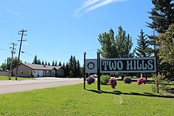
Two Hills, Alberta
Two Hills | |
|---|---|
Town | |
| Town of Two Hills | |
 | |
| Motto(s): Small Town With A Big Future | |
 Two Hills Location of Two Hills in Alberta | |
| Coordinates: 53°42′54″N 111°44′46″W / 53.71500°N 111.74611°W / 53.71500; -111.74611Coordinates: 53°42′54″N 111°44′46″W / 53.71500°N 111.74611°W / 53.71500; -111.74611 | |
| Country | |
| Province | |
| Region | Central Alberta |
| Census division | 10 |
| Municipal district | County of Two Hills No. 21 |
| Incorporated[1] | |
| • Village | June 4, 1929 |
| • Town | January 1, 1955 |
| Government [2] | |
| • Mayor | Leonard L. Ewanishan |
| • Governing body | Two Hills Town Council |
| Area (2016)[3] | |
| • Land | 3.38 km2 (1.31 sq mi) |
| Elevation [4] | 603 m (1,978 ft) |
| Population (2016)[3] | |
| • Total | 1,352 |
| • Density | 400/km2 (1,000/sq mi) |
| Time zone | UTC-7 (MST) |
| Postal code span | T0B 4K0 |
| Area code(s) | +1-780 |
| Highways | Highway 36 Highway 45 |
| Waterway | Vermilion River |
| Website | Official website |
Two Hills is a town in central Alberta, Canada. It is located approximately 137 km (85 mi) east of Edmonton at the junction of Highway 45 and Highway 36. Two Hills is primarily an agriculture-based community.
Contents
1 Demographics
2 See also
3 References
4 External links
Demographics
The population of the Town of Two Hills according to its 2017 municipal census is 1,443,[5] a change of 6999800000000000000♠0.8% from its 2012 municipal census population of 1,431.[6]
In the 2016 Census of Population conducted by Statistics Canada, the Town of Two Hills recorded a population of 1,352 living in 399 of its 478 total private dwellings, a 2999800000000000000♠−2% change from its 2011 population of 1,379. With a land area of 3.38 km2 (1.31 sq mi), it had a population density of 400.000400.0/km2 (1,035.9951,036.0/sq mi) in 2016.[3]
In the 2011 Census, the Town of Two Hills had a population of 1,379 living in 472 of its 522 total dwellings, a 31.7% change from its 2006 population of 1,047. With a land area of 3.31 km2 (1.28 sq mi), it had a population density of 416.616416.6/km2 (1,079.0311,079.0/sq mi) in 2011.[7]
See also
- List of communities in Alberta
- List of towns in Alberta
References
^ "Location and History Profile: Town of Two Hills" (PDF). Alberta Municipal Affairs. October 7, 2016. p. 674. Retrieved October 16, 2016..mw-parser-output cite.citationfont-style:inherit.mw-parser-output .citation qquotes:"""""""'""'".mw-parser-output .citation .cs1-lock-free abackground:url("//upload.wikimedia.org/wikipedia/commons/thumb/6/65/Lock-green.svg/9px-Lock-green.svg.png")no-repeat;background-position:right .1em center.mw-parser-output .citation .cs1-lock-limited a,.mw-parser-output .citation .cs1-lock-registration abackground:url("//upload.wikimedia.org/wikipedia/commons/thumb/d/d6/Lock-gray-alt-2.svg/9px-Lock-gray-alt-2.svg.png")no-repeat;background-position:right .1em center.mw-parser-output .citation .cs1-lock-subscription abackground:url("//upload.wikimedia.org/wikipedia/commons/thumb/a/aa/Lock-red-alt-2.svg/9px-Lock-red-alt-2.svg.png")no-repeat;background-position:right .1em center.mw-parser-output .cs1-subscription,.mw-parser-output .cs1-registrationcolor:#555.mw-parser-output .cs1-subscription span,.mw-parser-output .cs1-registration spanborder-bottom:1px dotted;cursor:help.mw-parser-output .cs1-ws-icon abackground:url("//upload.wikimedia.org/wikipedia/commons/thumb/4/4c/Wikisource-logo.svg/12px-Wikisource-logo.svg.png")no-repeat;background-position:right .1em center.mw-parser-output code.cs1-codecolor:inherit;background:inherit;border:inherit;padding:inherit.mw-parser-output .cs1-hidden-errordisplay:none;font-size:100%.mw-parser-output .cs1-visible-errorfont-size:100%.mw-parser-output .cs1-maintdisplay:none;color:#33aa33;margin-left:0.3em.mw-parser-output .cs1-subscription,.mw-parser-output .cs1-registration,.mw-parser-output .cs1-formatfont-size:95%.mw-parser-output .cs1-kern-left,.mw-parser-output .cs1-kern-wl-leftpadding-left:0.2em.mw-parser-output .cs1-kern-right,.mw-parser-output .cs1-kern-wl-rightpadding-right:0.2em
^ "Municipal Officials Search". Alberta Municipal Affairs. September 22, 2017. Retrieved September 25, 2017.
^ abc "Population and dwelling counts, for Canada, provinces and territories, and census subdivisions (municipalities), 2016 and 2011 censuses – 100% data (Alberta)". Statistics Canada. February 8, 2017. Retrieved February 8, 2017.
^ "Alberta Private Sewage Systems 2009 Standard of Practice Handbook: Appendix A.3 Alberta Design Data (A.3.A. Alberta Climate Design Data by Town)" (PDF) (PDF). Safety Codes Council. January 2012. pp. 212–215 (PDF pages 226–229). Retrieved October 9, 2013.
^ "2017 Municipal Affairs Population List" (PDF). Alberta Municipal Affairs. ISBN 978-1-4601-3652-2. Retrieved January 13, 2018.
^ "2016 Municipal Affairs Population List" (PDF). Alberta Municipal Affairs. ISBN 978-1-4601-3127-5. Retrieved January 13, 2018.
^ "Population and dwelling counts, for Canada, provinces and territories, and census subdivisions (municipalities), 2011 and 2006 censuses (Alberta)". Statistics Canada. 2012-02-08. Retrieved 2012-02-08.
External links
Official website