National Register of Historic Places listings in Clarke County, Virginia
[dummy-text]
National Register of Historic Places listings in Clarke County, Virginia
Jump to navigation
Jump to search

Location of Clarke County in Virginia
This is a list of the National Register of Historic Places listings in Clarke County, Virginia.
This is intended to be a complete list of the properties and districts on the National Register of Historic Places in Clarke County, Virginia, United States. The locations of National Register properties and districts for which the latitude and longitude coordinates are included below, may be seen in a Google map.[1]
There are 39 properties and districts listed on the National Register in the county, including 2 National Historic Landmarks.
This National Park Service list is complete through NPS recent listings posted November 2, 2018.[2]
Current listings[edit]
| [3] | Name on the Register[4] | Image | Date listed[5] | Location | City or town | Description |
|---|---|---|---|---|---|---|
1 | Annefield | 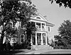 | November 12, 1969 (#69000231) | East of the junction of Annfield and Summerville Rds. 39°07′35″N 78°01′40″W / 39.126389°N 78.027778°W / 39.126389; -78.027778 (Annefield) | Boyce | |
2 | Bear's Den Rural Historic District |  | May 14, 2009 (#08001112) | Generally runs along both side of the ridge along parts of Raven Rocks and Blue Ridge Mountain Rds. 39°06′40″N 77°51′15″W / 39.111111°N 77.854167°W / 39.111111; -77.854167 (Bear's Den Rural Historic District) | Bluemont | |
3 | Berryville Historic District |  | November 3, 1987 (#87001881) | Junction of U.S. Route 340, State Route 7, and Main, Church, and Buckmarsh Sts. 39°09′04″N 77°58′53″W / 39.151111°N 77.981389°W / 39.151111; -77.981389 (Berryville Historic District) | Berryville | |
4 | Bethel Memorial Church |  | February 7, 1991 (#89001927) | Swift Shoals Rd. 39°01′46″N 78°02′47″W / 39.029444°N 78.046389°W / 39.029444; -78.046389 (Bethel Memorial Church) | White Post | |
5 | Blandy Experimental Farm Historic District |  | November 12, 1992 (#92001580) | Southern side of U.S. Routes 17/50, 4 miles (6.4 km) west of the Shenandoah River 39°03′50″N 78°03′55″W / 39.063889°N 78.065278°W / 39.063889; -78.065278 (Blandy Experimental Farm Historic District) | Boyce | |
6 | Boyce Historic District |  | March 8, 2004 (#04000155) | Includes Crescent Sts., Greenway Ave., Huntingdon Ln., Main St., Old Chapel Ave., Railroad Ln., and Saratoga, Virginia, and Whiting 39°05′36″N 78°03′36″W / 39.093333°N 78.060000°W / 39.093333; -78.060000 (Boyce Historic District) | Boyce | |
7 | Burwell-Morgan Mill |  | November 12, 1969 (#69000233) | At the junction of State Route 255 with Millwood Rd. 39°04′08″N 78°02′17″W / 39.06890°N 78.03805°W / 39.06890; -78.03805 (Burwell-Morgan Mill) | Millwood | |
8 | Carter Hall |  | July 24, 1973 (#73002003) | Northeast of Millwood off State Route 255 39°04′15″N 78°01′49″W / 39.070833°N 78.030278°W / 39.070833; -78.030278 (Carter Hall) | Millwood | |
9 | Chapel Hill |  | December 30, 2004 (#04000846) | 300 Chapel Hill Ln. 39°06′46″N 78°00′59″W / 39.112778°N 78.016389°W / 39.112778; -78.016389 (Chapel Hill) | Berryville | |
10 | Chapel Rural Historic District |  | February 14, 2014 (#14000010) | Generally centered along U.S. Route 340 39°05′30″N 78°01′21″W / 39.091667°N 78.022500°W / 39.091667; -78.022500 (Chapel Rural Historic District) | Millwood | |
11 | Cleridge |  | September 8, 2011 (#11000653) | 1649 Old Charles Town Rd. 39°13′26″N 78°03′32″W / 39.223889°N 78.058889°W / 39.223889; -78.058889 (Cleridge) | Stephenson | Extends into Frederick County |
12 | Clermont |  | July 27, 2005 (#05000767) | 801 E. Main St. 39°08′32″N 77°57′50″W / 39.142222°N 77.963889°W / 39.142222; -77.963889 (Clermont) | Berryville | |
13 | Cool Spring Battlefield |  | June 6, 1997 (#97000492) | Junction of State Route 7 and the Shenandoah River 39°07′30″N 77°53′24″W / 39.125000°N 77.890000°W / 39.125000; -77.890000 (Cool Spring Battlefield) | Berryville | |
14 | Fairfield |  | February 26, 1970 (#70000787) | East of the junction of U.S. Route 340 and Clifton Rd. 39°11′05″N 77°56′07″W / 39.184722°N 77.935278°W / 39.184722; -77.935278 (Fairfield) | Berryville | |
15 | Farnley |  | November 2, 1989 (#89001914) | Sugar Hill Rd. and Bordens Spring Rd. 39°01′21″N 78°06′57″W / 39.022500°N 78.115833°W / 39.022500; -78.115833 (Farnley) | White Post | |
16 | Glendale Farm |  | March 17, 1995 (#95000244) | Northern side of the junction of Old Charles Town and Crum Church Rds. 39°13′42″N 78°00′42″W / 39.228333°N 78.011667°W / 39.228333; -78.011667 (Glendale Farm) | Berryville | |
17 | Greenway Court |  | October 15, 1966 (#66000829) | 1 mile (1.6 km) south of White Post on State Route 277 39°02′48″N 78°07′09″W / 39.046528°N 78.119167°W / 39.046528; -78.119167 (Greenway Court) | White Post | Remnants of 5,000,000-acre (20,000 km2) estate of Thomas Fairfax, 6th Lord Fairfax of Cameron, only British peer in America, where George Washington worked as a surveyor |
18 | Greenway Historic District |  | November 4, 1993 (#93001133) | Roughly bounded by the Shenandoah River, the Warren County line, U.S. Route 340, and Locke's Mill Rd.; also the eastern side of State Route 255, approximately 0.2 miles north of its junction with Millwood Rd.; also 14374 U.S. Route 340 39°03′29″N 78°06′14″W / 39.058056°N 78.103889°W / 39.058056; -78.103889 (Greenway Historic District) | Boyce | Second set of boundaries and U.S. Route 340 represent boundary increases of February 21, 1997 and October 30, 2007 |
19 | Guilford | 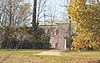 | February 4, 1993 (#93000004) | Southern side of Stone Bridge Rd., 0.5 miles (0.80 km) west of its junction with Sugar Hill Rd. 39°01′07″N 78°05′53″W / 39.018611°N 78.098194°W / 39.018611; -78.098194 (Guilford) | White Post | |
20 | Huntingdon |  | May 25, 1979 (#79003035) | North of Boyce 39°06′09″N 78°03′18″W / 39.102500°N 78.055000°W / 39.102500; -78.055000 (Huntingdon) | Boyce | |
21 | Josephine City Historic District | 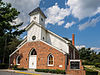 | May 18, 2015 (#15000250) | Josephine St. 39°08′36″N 77°58′55″W / 39.143333°N 77.981944°W / 39.143333; -77.981944 (Josephine City Historic District) | Berryville | |
22 | Josephine City School | 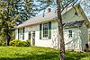 | April 7, 1995 (#95000397) | 301-A Josephine St. 39°08′28″N 77°58′46″W / 39.141111°N 77.979444°W / 39.141111; -77.979444 (Josephine City School) | Berryville | |
23 | Long Branch |  | October 1, 1969 (#69000232) | West of the junction of Bordens Spring and Red Gate Rds. 39°02′27″N 78°03′21″W / 39.040833°N 78.055833°W / 39.040833; -78.055833 (Long Branch) | Millwood | |
24 | Long Marsh Run Rural Historic District |  | November 4, 1996 (#96001173) | Roughly bounded by the West Virginia state line, Wickliffe Rd., Shepherds Mill Rd., State Route 7, and Kimble Rd. 39°09′22″N 77°55′08″W / 39.156111°N 77.918889°W / 39.156111; -77.918889 (Long Marsh Run Rural Historic District) | Berryville | |
25 | Lucky Hit |  | August 12, 1993 (#93000834) | Southern side of Berrys Ferry Rd., 4,500 feet (1,400 m) northeast of its junction with White Post Rd. 39°03′18″N 78°05′37″W / 39.055000°N 78.093611°W / 39.055000; -78.093611 (Lucky Hit) | White Post | |
26 | Meadea |  | February 8, 1995 (#95000022) | Southern side of Berrys Ferry Rd., 600 feet (180 m) east of its junction with White Post Rd. 39°03′25″N 78°06′07″W / 39.057083°N 78.101944°W / 39.057083; -78.101944 (Meadea) | White Post | |
27 | Millwood Colored School |  | November 22, 2000 (#00001431) | 1610 Millwood Rd. 39°04′29″N 78°02′31″W / 39.074722°N 78.041944°W / 39.074722; -78.041944 (Millwood Colored School) | Boyce | |
28 | Millwood Commercial Historic District |  | January 31, 2006 (#05001624) | Parts of Millwood Rd. and Tannery Ln. 39°04′11″N 78°02′17″W / 39.069722°N 78.038056°W / 39.069722; -78.038056 (Millwood Commercial Historic District) | Millwood | |
29 | Norwood |  | September 30, 1994 (#94001180) | Southern side of State Route 7, 0.9 miles (1.4 km) east of its junction with State Route 7 Business 39°08′22″N 77°57′00″W / 39.139444°N 77.950000°W / 39.139444; -77.950000 (Norwood) | Berryville | |
30 | Old Chapel |  | April 2, 1973 (#73002004) | 3 miles (4.8 km) north of Millwood off U.S. Route 340 39°06′27″N 78°00′51″W / 39.107500°N 78.014167°W / 39.107500; -78.014167 (Old Chapel) | Millwood | |
31 | Old Clarke County Courthouse |  | July 7, 1983 (#83003277) | 104 N. Church St. 39°09′07″N 77°58′49″W / 39.151944°N 77.980278°W / 39.151944; -77.980278 (Old Clarke County Courthouse) | Berryville | |
32 | River House |  | December 23, 1993 (#93001440) | U.S. Routes 17/50, 2.5 miles (4.0 km) east of Millwood 39°02′32″N 78°00′06″W / 39.042222°N 78.001667°W / 39.042222; -78.001667 (River House) | Millwood | |
33 | Saratoga |  | February 26, 1970 (#70000788) | Millwood Rd. 39°05′00″N 78°03′36″W / 39.083333°N 78.060000°W / 39.083333; -78.060000 (Saratoga) | Boyce | Gray limestone Georgian house built by Brig. Gen. Daniel Morgan, best known for his victory over the British at the Battle of Cowpens in 1781. |
34 | Scaleby |  | December 28, 1990 (#90002000) | Millwood Rd., south of its junction with U.S. Route 340 39°05′12″N 78°02′55″W / 39.086667°N 78.048611°W / 39.086667; -78.048611 (Scaleby) | Boyce | |
35 | Smithfield Farm |  | February 16, 2001 (#01000148) | 568 Smithfield Ln. 39°10′24″N 77°53′58″W / 39.173333°N 77.899444°W / 39.173333; -77.899444 (Smithfield Farm) | Berryville | |
36 | Soldier's Rest |  | May 23, 1996 (#96000579) | 0.3 miles (0.48 km) north of Fairfax Ave. and approximately 0.5 miles (0.80 km) east of the junction of U.S. Route 340 and State Route 7 39°09′25″N 77°58′16″W / 39.156944°N 77.971111°W / 39.156944; -77.971111 (Soldier's Rest) | Berryville | |
37 | The Tuleyries |  | August 7, 1972 (#72001388) | 1.5 miles (2.4 km) east of White Post off Berrys Ferry Rd. 39°03′57″N 78°04′12″W / 39.065833°N 78.070000°W / 39.065833; -78.070000 (The Tuleyries) | White Post | |
38 | White Post Historic District |  | September 29, 1983 (#83003278) | Berrys Ferry and White Post Rds. 39°03′29″N 78°06′12″W / 39.058056°N 78.103333°W / 39.058056; -78.103333 (White Post Historic District) | White Post | |
39 | Wickliffe Church |  | March 17, 1995 (#95000241) | Eastern side of Wickliffe Rd., 0.5 miles (0.80 km) south of the West Virginia line 39°09′59″N 77°53′31″W / 39.166250°N 77.891944°W / 39.166250; -77.891944 (Wickliffe Church) | Berryville |
See also[edit]
| Wikimedia Commons has media related to National Register of Historic Places in Clarke County, Virginia. |
- List of National Historic Landmarks in Virginia
- National Register of Historic Places listings in Virginia
References[edit]
^ The latitude and longitude information provided in this table was derived originally from the National Register Information System, which has been found to be fairly accurate for about 99% of listings. For about 1% of NRIS original coordinates, experience has shown that one or both coordinates are typos or otherwise extremely far off; some corrections may have been made. A more subtle problem causes many locations to be off by up to 150 yards, depending on location in the country: most NRIS coordinates were derived from tracing out latitude and longitudes from USGS topographical quadrant maps created under the North American Datum of 1927, which differs from the current, highly accurate WGS84 GPS system used by most on-line maps. Chicago is about right, but NRIS longitudes in Washington are higher by about 4.5 seconds, and are lower by about 2.0 seconds in Maine. Latitudes differ by about 1.0 second in Florida. Some locations in this table may have been corrected to current GPS standards.
^ "National Register of Historic Places: Weekly List Actions". National Park Service, United States Department of the Interior. Retrieved on November 2, 2018.
^ Numbers represent an ordering by significant words. Various colorings, defined here, differentiate National Historic Landmarks and historic districts from other NRHP buildings, structures, sites or objects.
^ National Park Service (2008-04-24). "National Register Information System". National Register of Historic Places. National Park Service..mw-parser-output cite.citationfont-style:inherit.mw-parser-output qquotes:"""""""'""'".mw-parser-output code.cs1-codecolor:inherit;background:inherit;border:inherit;padding:inherit.mw-parser-output .cs1-lock-free abackground:url("//upload.wikimedia.org/wikipedia/commons/thumb/6/65/Lock-green.svg/9px-Lock-green.svg.png")no-repeat;background-position:right .1em center.mw-parser-output .cs1-lock-limited a,.mw-parser-output .cs1-lock-registration abackground:url("//upload.wikimedia.org/wikipedia/commons/thumb/d/d6/Lock-gray-alt-2.svg/9px-Lock-gray-alt-2.svg.png")no-repeat;background-position:right .1em center.mw-parser-output .cs1-lock-subscription abackground:url("//upload.wikimedia.org/wikipedia/commons/thumb/a/aa/Lock-red-alt-2.svg/9px-Lock-red-alt-2.svg.png")no-repeat;background-position:right .1em center.mw-parser-output .cs1-subscription,.mw-parser-output .cs1-registrationcolor:#555.mw-parser-output .cs1-subscription span,.mw-parser-output .cs1-registration spanborder-bottom:1px dotted;cursor:help.mw-parser-output .cs1-hidden-errordisplay:none;font-size:100%.mw-parser-output .cs1-visible-errorfont-size:100%.mw-parser-output .cs1-subscription,.mw-parser-output .cs1-registration,.mw-parser-output .cs1-formatfont-size:95%.mw-parser-output .cs1-kern-left,.mw-parser-output .cs1-kern-wl-leftpadding-left:0.2em.mw-parser-output .cs1-kern-right,.mw-parser-output .cs1-kern-wl-rightpadding-right:0.2em
^ The eight-digit number below each date is the number assigned to each location in the National Register Information System database, which can be viewed by clicking the number.
U.S. National Register of Historic Places in Virginia | ||
|---|---|---|
| Lists by county |
|   |
| Lists by city |
| |
| Other lists |
| |
| ||
Municipalities and communities of Clarke County, Virginia, United States | ||
|---|---|---|
County seat: Berryville | ||
| Towns |
|  |
| CDPs |
| |
| Unincorporated communities |
| |
| Footnotes | ‡This populated place also has portions in an adjacent county or counties | |
Categories:
- National Register of Historic Places in Clarke County, Virginia
- Lists of National Register of Historic Places in Virginia by county
(window.RLQ=window.RLQ||).push(function()mw.config.set("wgPageParseReport":"limitreport":"cputime":"0.692","walltime":"0.874","ppvisitednodes":"value":16092,"limit":1000000,"ppgeneratednodes":"value":0,"limit":1500000,"postexpandincludesize":"value":277000,"limit":2097152,"templateargumentsize":"value":20999,"limit":2097152,"expansiondepth":"value":11,"limit":40,"expensivefunctioncount":"value":0,"limit":500,"unstrip-depth":"value":1,"limit":20,"unstrip-size":"value":5714,"limit":5000000,"entityaccesscount":"value":1,"limit":400,"timingprofile":["100.00% 570.911 1 -total"," 64.58% 368.675 39 Template:NRHP_row"," 17.01% 97.130 1 Template:NRHP_header"," 13.78% 78.645 1 Template:NRISref"," 13.19% 75.301 1 Template:Cite_web"," 13.11% 74.828 78 Template:First_word"," 11.69% 66.757 39 Template:Coord"," 11.47% 65.468 40 Template:Designation/color"," 10.37% 59.187 41 Template:Dts"," 8.49% 48.458 32 Template:NRHP_color"],"scribunto":"limitreport-timeusage":"value":"0.225","limit":"10.000","limitreport-memusage":"value":6575293,"limit":52428800,"cachereport":"origin":"mw1320","timestamp":"20181111223013","ttl":1900800,"transientcontent":false);mw.config.set("wgBackendResponseTime":83,"wgHostname":"mw1272"););


