National Register of Historic Places listings in Fairfax County, Virginia
[dummy-text]
National Register of Historic Places listings in Fairfax County, Virginia
Jump to navigation
Jump to search

Location of Fairfax County in Virginia
This is a list of the National Register of Historic Places listings in Fairfax County, Virginia.
This is intended to be a complete list of the properties and districts on the National Register of Historic Places in Fairfax County, Virginia, United States. The locations of National Register properties and districts for which the latitude and longitude coordinates are included below, may be seen in an online map.[1]
There are 61 properties and districts listed on the National Register in the county, including 4 National Historic Landmarks. Another property was once listed but has been removed.
This National Park Service list is complete through NPS recent listings posted November 2, 2018.[2]
Current listings[edit]
| [3] | Name on the Register | Image | Date listed[4] | Location | City or town | Description |
|---|---|---|---|---|---|---|
1 | "A" Fort and Battery Hill Redoubt-Camp Early |  | October 30, 1998 (#98001315) | Balmoral Greens Ave., 1 mile (1.6 km) south of the junction with Compton Rd. 38°47′22″N 77°25′40″W / 38.789444°N 77.427778°W / 38.789444; -77.427778 ("A" Fort and Battery Hill Redoubt-Camp Early) | Manassas Park | |
2 | Belvoir Mansion Ruins and the Fairfax Grave |  | June 4, 1973 (#73002337) | Southeast of the junction of 23rd St. and Belvoir Rd. 38°40′50″N 77°07′42″W / 38.680694°N 77.128333°W / 38.680694; -77.128333 (Belvoir Mansion Ruins and the Fairfax Grave) | Fort Belvoir | |
3 | Bloomfield |  | February 5, 2013 (#12001266) | 12000 Leesburg Pike 39°00′37″N 77°21′34″W / 39.010278°N 77.359444°W / 39.010278; -77.359444 (Bloomfield) | Herndon | |
4 | A. Smith Bowman Distillery |  | December 9, 1999 (#99001503) | 1875 Old Reston Ave. 38°57′24″N 77°21′05″W / 38.956667°N 77.351389°W / 38.956667; -77.351389 (A. Smith Bowman Distillery) | Reston | |
5 | Clifton Historic District |  | August 15, 1985 (#85001786) | Roughly bounded by Popes Head Creek, Water St., Dell Ave., and Chestnut and Chapel Rds. 38°46′46″N 77°23′11″W / 38.779444°N 77.386389°W / 38.779444; -77.386389 (Clifton Historic District) | Clifton | |
6 | Colvin Run Mill |  | August 16, 1977 (#77001487) | South of Great Falls at 10017 Colvin Run Rd. 38°58′07″N 77°17′35″W / 38.968611°N 77.293056°W / 38.968611; -77.293056 (Colvin Run Mill) | Great Falls | |
7 | Cornwell Farm |  | April 13, 1977 (#77001488) | Southeast of Great Falls, 9414 Georgetown Pike 38°59′30″N 77°16′17″W / 38.991528°N 77.271389°W / 38.991528; -77.271389 (Cornwell Farm) | Great Falls | |
8 | D.C. Workhouse and Reformatory Historic District |  | February 16, 2006 (#06000052) | Between Silverbrook Rd., Lorton Rd., Ox Rd., and Furnace Rd. 38°41′53″N 77°15′16″W / 38.698056°N 77.254444°W / 38.698056; -77.254444 (D.C. Workhouse and Reformatory Historic District) | Lorton | |
9 | Dranesville Tavern |  | November 9, 1972 (#72001393) | 11919 Leesburg Pike 39°00′29″N 77°21′37″W / 39.008056°N 77.360278°W / 39.008056; -77.360278 (Dranesville Tavern) | Dranesville | |
10 | Fairfax Arms |  | May 21, 1979 (#79003037) | 10712 Old Colchester Rd. 38°40′06″N 77°14′08″W / 38.668333°N 77.235556°W / 38.668333; -77.235556 (Fairfax Arms) | Colchester | |
11 | Floris Historic District |  | August 12, 2010 (#10000543) | Bounded by Centreville Rd., W. Ox Rd., Monroe St., and Frying Pan Branch 38°56′11″N 77°24′35″W / 38.936389°N 77.409722°W / 38.936389; -77.409722 (Floris Historic District) | Herndon | |
12 | Fort Hunt | March 26, 1980 (#80000353) | George Washington Memorial Parkway 38°42′54″N 77°03′07″W / 38.715000°N 77.051944°W / 38.715000; -77.051944 (Fort Hunt) | Alexandria | ||
13 | Four Stairs |  | August 11, 2004 (#04000842) | 840 Leigh Mill Rd. 38°59′04″N 77°16′36″W / 38.984444°N 77.276667°W / 38.984444; -77.276667 (Four Stairs) | Great Falls | |
14 | Freeman Store |  | May 16, 2012 (#11000834) | 131 Church St., NE. 38°54′12″N 77°15′54″W / 38.903333°N 77.265000°W / 38.903333; -77.265000 (Freeman Store) | Vienna | |
15 | Frying Pan Meetinghouse |  | February 5, 1991 (#91000016) | 2615 Centreville Rd. 38°56′24″N 77°24′47″W / 38.940000°N 77.413056°W / 38.940000; -77.413056 (Frying Pan Meetinghouse) | Floris | |
16 | George Washington Memorial Parkway |  | June 2, 1995 (#95000605) | Roughly the southern side of the Potomac River from the American Legion to the Memorial Bridge and the north side from Brickyard Rd. to the Chain Bridge 38°57′38″N 77°08′54″W / 38.960556°N 77.148333°W / 38.960556; -77.148333 (George Washington Memorial Parkway) | Langley | |
17 | Georgetown Pike |  | August 22, 2012 (#12000537) | From the District of Columbia boundary at the Chain Bridge to the junction with Leesburg Pike at Seneca Rd. 38°57′14″N 77°11′31″W / 38.953889°N 77.191944°W / 38.953889; -77.191944 (Georgetown Pike) | McLean | Extends into Arlington County |
18 | Great Falls Grange Hall and Forestville School |  | August 11, 2004 (#04000861) | 9812 and 9818 Georgetown Pike 38°59′52″N 77°17′08″W / 38.997778°N 77.285556°W / 38.997778; -77.285556 (Great Falls Grange Hall and Forestville School) | Great Falls | |
19 | Great Falls Park Historic District |  | December 22, 2014 (#14001079) | Bounded by the Potomac River, Georgetown Pike, and River Bend Rd. 38°59′30″N 77°15′02″W / 38.991667°N 77.250556°W / 38.991667; -77.250556 (Great Falls Park Historic District) | Great Falls | |
20 | Green Spring |  | October 22, 2003 (#03001089) | 4601 Green Spring Rd. 38°49′28″N 77°09′26″W / 38.824444°N 77.157222°W / 38.824444; -77.157222 (Green Spring) | Alexandria | |
21 | John Gunnell House |  | November 27, 2006 (#06001100) | 489 Arnon Meadow Rd. 39°00′48″N 77°17′23″W / 39.013333°N 77.289722°W / 39.013333; -77.289722 (John Gunnell House) | Great Falls | |
22 | William Gunnell House |  | May 22, 2003 (#03000447) | 600 Insbruck Ave. 39°00′13″N 77°17′05″W / 39.003611°N 77.284722°W / 39.003611; -77.284722 (William Gunnell House) | Great Falls | |
23 | Gunston Hall |  | October 15, 1966 (#66000832) | 10709 Gunston Rd. 38°39′51″N 77°09′37″W / 38.664167°N 77.160278°W / 38.664167; -77.160278 (Gunston Hall) | Mason Neck | |
24 | Herndon Depot |  | June 18, 1979 (#79003039) | Elden St. 38°58′13″N 77°23′12″W / 38.970278°N 77.386583°W / 38.970278; -77.386583 (Herndon Depot) | Herndon | |
25 | Herndon Historic District |  | January 11, 1991 (#90002121) | Roughly bounded by Locust, Spring, Pearl, Monroe, Station, and Vine Sts. 38°58′06″N 77°23′05″W / 38.968333°N 77.384722°W / 38.968333; -77.384722 (Herndon Historic District) | Herndon | |
26 | Hollin Hills Historic District |  | September 30, 2013 (#13000807) | Roughly Beechwood, Elba, Glasgow, Martha's, Paul Springs, Range, and Stafford Rds., and Mason Hill, Rebecca, and Whiteoaks Drs. 38°45′24″N 77°04′02″W / 38.756667°N 77.067222°W / 38.756667; -77.067222 (Hollin Hills Historic District) | Alexandria | |
27 | Holmes Run Acres Historic District |  | March 22, 2007 (#07000230) | Generally bounded by Gallows Rd., Surrey Ln, and Holmes Run Dr. 38°51′09″N 77°12′38″W / 38.852500°N 77.210556°W / 38.852500; -77.210556 (Holmes Run Acres Historic District) | Falls Church | |
28 | Hope Park Mill and Miller's House |  | August 15, 1977 (#77001486) | 12124 Pope's Head Rd. 38°48′55″N 77°21′56″W / 38.815139°N 77.365694°W / 38.815139; -77.365694 (Hope Park Mill and Miller's House) | Fairfax | |
29 | Huntley |  | November 3, 1972 (#72001392) | 6918 Harrison Lane 38°45′56″N 77°05′41″W / 38.765694°N 77.094722°W / 38.765694; -77.094722 (Huntley) | Alexandria | |
30 | Langley Fork Historic District |  | October 19, 1982 (#82001818) | Junction of Georgetown Pike and Old Chain Bridge Rd. 38°56′46″N 77°09′36″W / 38.946111°N 77.16°W / 38.946111; -77.16 (Langley Fork Historic District) | Langley | |
31 | Lake Anne Village Center Historic District |  | June 5, 2017 (#100001041) | North Shore Dr. and Washington Plaza W. and N. 38°58′08″N 77°20′27″W / 38.968889°N 77.340833°W / 38.968889; -77.340833 (Lake Anne Village Center Historic District) | Reston | |
32 | Lexington |  | May 28, 2013 (#13000336) | 7301 High Point Rd. 38°39′37″N 77°10′28″W / 38.660278°N 77.174444°W / 38.660278; -77.174444 (Lexington) | Lorton | |
33 | Manassas National Battlefield Park |  | October 15, 1966 (#66000039) | Northwest of Manassas off State Route 215 38°49′28″N 77°30′12″W / 38.824444°N 77.503333°W / 38.824444; -77.503333 (Manassas National Battlefield Park) | Manassas | Boundaries increased on January 18, 2006, but no location details specified |
34 | Merrybrook |  | April 26, 2007 (#07000362) | 2346 Centreville Rd. 38°57′14″N 77°24′30″W / 38.953889°N 77.408333°W / 38.953889; -77.408333 (Merrybrook) | Herndon | |
35 | Mount Vernon | 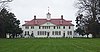 | October 15, 1966 (#66000833) | 7 miles (11 km) south of Alexandria on the George Washington Memorial Parkway 38°42′29″N 77°05′10″W / 38.708056°N 77.086111°W / 38.708056; -77.086111 (Mount Vernon) | Alexandria | |
36 | Mount Vernon High School |  | May 11, 2018 (#100002439) | 8333 Richmond Hwy. 38°43′53″N 77°06′06″W / 38.7314°N 77.1017°W / 38.7314; -77.1017 (Mount Vernon High School) | Alexandria vicinity | The 1939 building, not the current school. |
37 | Mount Vernon Memorial Highway |  | May 18, 1981 (#81000079) | Washington St. and the George Washington Memorial Parkway 38°46′30″N 77°03′07″W / 38.775000°N 77.051944°W / 38.775000; -77.051944 (Mount Vernon Memorial Highway) | McLean | |
38 | Northwest No. 3 Boundary Marker of the Original District of Columbia |  | February 1, 1991 (#91000005) | 4013 N. Tazewell St. 38°55′28″N 77°07′55″W / 38.924583°N 77.132083°W / 38.924583; -77.132083 (Northwest No. 3 Boundary Marker of the Original District of Columbia) | McLean | |
39 | Oak Hill |  | May 19, 2004 (#04000478) | 4716 Wakefield Chapel Rd. 38°49′15″N 77°14′24″W / 38.820972°N 77.240000°W / 38.820972; -77.240000 (Oak Hill) | Annandale | |
40 | Oakton Trolley Station |  | February 8, 1995 (#95000026) | 2923 Gray St. 38°52′46″N 77°17′49″W / 38.879444°N 77.296944°W / 38.879444; -77.296944 (Oakton Trolley Station) | Oakton | |
41 | Orange and Alexandria Railroad Bridge Piers | 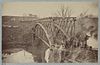 | August 8, 1989 (#89001061) | Both sides of Bull Run just east of Manassas Park[5] 38°46′35″N 77°25′17″W / 38.776389°N 77.421389°W / 38.776389; -77.421389 (Orange and Alexandria Railroad Bridge Piers) | Manassas Park | Extends into Prince William County |
42 | Pohick Church |  | October 16, 1969 (#69000239) | 9201 U.S. Route 1 38°42′33″N 77°11′38″W / 38.709028°N 77.193889°W / 38.709028; -77.193889 (Pohick Church) | Lorton | |
43 | Pope-Leighey House | 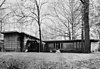 | December 18, 1970 (#70000791) | East of Accotink off U.S. Route 1 38°43′10″N 77°08′10″W / 38.719444°N 77.136111°W / 38.719444; -77.136111 (Pope-Leighey House) | Accotink | |
44 | Potomac Canal Historic District |  | October 18, 1979 (#79003038) | East of Great Falls 38°59′44″N 77°15′14″W / 38.995556°N 77.253889°W / 38.995556; -77.253889 (Potomac Canal Historic District) | Great Falls | |
45 | St. Mary's Church | 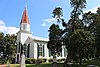 | July 1, 1976 (#76002104) | 5605 Vogue Rd. 38°48′10″N 77°19′36″W / 38.802778°N 77.326667°W / 38.802778; -77.326667 (St. Mary's Church) | Fairfax Station | |
46 | Salona |  | July 24, 1973 (#73002011) | 1214 Buchanan St. 38°56′17″N 77°10′15″W / 38.937917°N 77.170833°W / 38.937917; -77.170833 (Salona) | McLean | |
47 | Silverbrook Methodist Church |  | January 16, 2004 (#03001438) | 8616 Silverbrook Rd. 38°43′33″N 77°14′35″W / 38.725833°N 77.242917°W / 38.725833; -77.242917 (Silverbrook Methodist Church) | Lorton | |
48 | Southwest No. 6 Boundary Marker of the Original District of Columbia |  | February 1, 1991 (#91000011) | S. Jefferson St. south of the junction with Columbia Pike, in the median strip 38°51′07″N 77°07′09″W / 38.851889°N 77.119250°W / 38.851889; -77.119250 (Southwest No. 6 Boundary Marker of the Original District of Columbia) | Bailey's Crossroads | |
49 | Southwest No. 7 Boundary Marker of the Original District of Columbia |  | February 1, 1991 (#91000012) | Behind 3101 S. Manchester St. 38°51′45″N 77°07′58″W / 38.862500°N 77.132778°W / 38.862500; -77.132778 (Southwest No. 7 Boundary Marker of the Original District of Columbia) | Seven Corners | |
50 | Southwest No. 8 Boundary Marker of the Original District of Columbia | 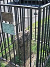 | February 1, 1991 (#91000013) | Junction of Wilson Boulevard and John Marshall Dr., behind an apartment building 38°52′22″N 77°08′45″W / 38.872639°N 77.145833°W / 38.872639; -77.145833 (Southwest No. 8 Boundary Marker of the Original District of Columbia) | Seven Corners | Extends into Arlington County |
51 | Spring Hill Farm |  | November 22, 2002 (#02000446) | 1121 Spring Hill Rd. 38°56′53″N 77°13′32″W / 38.948056°N 77.225556°W / 38.948056; -77.225556 (Spring Hill Farm) | McLean | |
52 | Sully |  | December 18, 1970 (#70000793) | North of the junction of U.S. Route 50 and State Route 28 38°54′28″N 77°25′51″W / 38.907778°N 77.430833°W / 38.907778; -77.430833 (Sully) | Chantilly | |
53 | Sydenstricker School |  | August 22, 2012 (#12000539) | 8511 Hooes Rd. 38°45′20″N 77°14′21″W / 38.755694°N 77.239167°W / 38.755694; -77.239167 (Sydenstricker School) | Springfield | |
54 | Taft Archeological Site#029-5411 |  | August 11, 2004 (#04000859) | Address Restricted 38°38′55″N 77°11′40″W / 38.648611°N 77.194444°W / 38.648611; -77.194444 (Taft Archeological Site#029-5411) | Lorton | |
55 | Tauxemont Historic District | 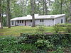 | February 9, 2006 (#06000033) | Between Fort Hunt Rd. and Accotink Place, including Shenandoah, Tauxemont, Namassin, Westmoreland and Gahant Rds., and Bolling 38°44′42″N 77°03′20″W / 38.745000°N 77.055556°W / 38.745000; -77.055556 (Tauxemont Historic District) | Alexandria | |
56 | Tower House |  | May 2, 2006 (#06000341) | 9066 Tower House Place 38°42′41″N 77°04′01″W / 38.711389°N 77.066944°W / 38.711389; -77.066944 (Tower House) | Alexandria | |
57 | Vale School-Community House |  | June 8, 2011 (#11000349) | 3124 Fox Mill Rd. 38°53′30″N 77°20′56″W / 38.891667°N 77.348889°W / 38.891667; -77.348889 (Vale School-Community House) | Oakton | |
58 | George Washington's Gristmill |  | August 8, 2003 (#03000739) | 5512 George Washington Memorial Parkway 38°42′47″N 77°07′48″W / 38.713056°N 77.130000°W / 38.713056; -77.130000 (George Washington's Gristmill) | Lorton | |
59 | West Cornerstone | 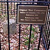 | February 1, 1991 (#91000014) | West side of Meridian St., south of the junction with Williamsburg Boulevard 38°53′36″N 77°10′20″W / 38.893333°N 77.172222°W / 38.893333; -77.172222 (West Cornerstone) | Falls Church | |
60 | Woodlawn Plantation |  | February 26, 1970 (#70000792) | West of the junction of U.S. Route 1 and State Route 235; also 9000 U.S. Route 1 38°43′03″N 77°08′14″W / 38.717500°N 77.137222°W / 38.717500; -77.137222 (Woodlawn Plantation) | Alexandria | 9000 Richmond represents a boundary increase of November 18, 2011 |
61 | Woodlawn Quaker Meetinghouse |  | May 21, 2009 (#09000335) | 8990 Woodlawn Rd. 38°42′51″N 77°08′32″W / 38.714167°N 77.142222°W / 38.714167; -77.142222 (Woodlawn Quaker Meetinghouse) | Fort Belvoir |
Former listing[edit]
| [3] | Name on the Register | Image | Date listed | Date removed | Location | City or town | Summary |
|---|---|---|---|---|---|---|---|
1 | Moorefield |  | April 19, 1978 (#78003014) | June 10, 2005 | Moorefield Hill Place | Vienna | Dismantled in February 2003 |
See also[edit]
| Wikimedia Commons has media related to National Register of Historic Places in Fairfax County, Virginia. |
- List of National Historic Landmarks in Virginia
- National Register of Historic Places listings in Virginia
- National Register of Historic Places listings in Alexandria, Virginia
- National Register of Historic Places listings in Fairfax, Virginia
- National Register of Historic Places listings in Falls Church, Virginia
References[edit]
^ The latitude and longitude information provided in this table was derived originally from the National Register Information System, which has been found to be fairly accurate for about 99% of listings. For about 1% of NRIS original coordinates, experience has shown that one or both coordinates are typos or otherwise extremely far off; some corrections may have been made. A more subtle problem causes many locations to be off by up to 150 yards, depending on location in the country: most NRIS coordinates were derived from tracing out latitude and longitudes from USGS topographical quadrant maps created under the North American Datum of 1927, which differs from the current, highly accurate WGS84 GPS system used by most on-line maps. Chicago is about right, but NRIS longitudes in Washington are higher by about 4.5 seconds, and are lower by about 2.0 seconds in Maine. Latitudes differ by about 1.0 second in Florida. Some locations in this table may have been corrected to current GPS standards.
^ "National Register of Historic Places: Weekly List Actions". National Park Service, United States Department of the Interior. Retrieved on November 2, 2018.
^ ab Numbers represent an ordering by significant words. Various colorings, defined here, differentiate National Historic Landmarks and historic districts from other NRHP buildings, structures, sites or objects.
^ The eight-digit number below each date is the number assigned to each location in the National Register Information System database, which can be viewed by clicking the number.
^ Myers, L. Daniel. National Register of Historic Places Inventory/Nomination: Orange and Alexandria Railroad Bridge Piers. National Park Service, 1989-05, 11.
U.S. National Register of Historic Places in Virginia | ||
|---|---|---|
| Lists by county |
|   |
| Lists by city |
| |
| Other lists |
| |
| ||
Municipalities and communities of Fairfax County, Virginia, United States | ||
|---|---|---|
County seat: Fairfax | ||
| Towns |
|  |
| CDPs |
| |
| Unincorporated communities |
| |
| Ghost towns |
| |
Categories:
- National Register of Historic Places in Fairfax County, Virginia
- Lists of National Register of Historic Places in Virginia by county
(window.RLQ=window.RLQ||).push(function()mw.config.set("wgPageParseReport":"limitreport":"cputime":"0.992","walltime":"1.190","ppvisitednodes":"value":24478,"limit":1000000,"ppgeneratednodes":"value":0,"limit":1500000,"postexpandincludesize":"value":411739,"limit":2097152,"templateargumentsize":"value":35485,"limit":2097152,"expansiondepth":"value":10,"limit":40,"expensivefunctioncount":"value":0,"limit":500,"unstrip-depth":"value":0,"limit":20,"unstrip-size":"value":3946,"limit":5000000,"entityaccesscount":"value":1,"limit":400,"timingprofile":["100.00% 744.587 1 -total"," 76.14% 566.940 62 Template:NRHP_row"," 17.15% 127.705 122 Template:First_word"," 14.46% 107.674 62 Template:Designation/color"," 13.87% 103.252 61 Template:Coord"," 11.94% 88.896 65 Template:Dts"," 11.66% 86.848 58 Template:NRHP_color"," 10.42% 77.585 61 Template:NRHP_Focus"," 5.40% 40.192 1 Template:Distinguish"," 4.85% 36.115 1 Template:Commons_category"],"scribunto":"limitreport-timeusage":"value":"0.281","limit":"10.000","limitreport-memusage":"value":5093655,"limit":52428800,"cachereport":"origin":"mw1336","timestamp":"20181111225805","ttl":1900800,"transientcontent":false);mw.config.set("wgBackendResponseTime":91,"wgHostname":"mw1253"););


