National Register of Historic Places listings in Frederick County, Virginia
[dummy-text]
National Register of Historic Places listings in Frederick County, Virginia
Jump to navigation
Jump to search

Location of Frederick County in Virginia
This is a list of the National Register of Historic Places listings in Frederick County, Virginia.
This is intended to be a complete list of the properties and districts on the National Register of Historic Places in Frederick County, Virginia, United States. The locations of National Register properties and districts for which the latitude and longitude coordinates are included below, may be seen in an online map.[1]
There are 28 properties and districts listed on the National Register in the county, including 1 National Historic Landmark.
This National Park Service list is complete through NPS recent listings posted November 2, 2018.[2]
Current listings[edit]
| [3] | Name on the Register[4] | Image | Date listed[5] | Location | City or town | Description |
|---|---|---|---|---|---|---|
1 | Willa Cather Birthplace |  | November 16, 1978 (#78003017) | Northwest of Gore on U.S. Route 50 39°16′04″N 78°19′26″W / 39.267778°N 78.323889°W / 39.267778; -78.323889 (Willa Cather Birthplace) | Gore | |
2 | Cedar Creek Battlefield and Belle Grove |  | August 11, 1969 (#69000243) | On Interstate 81 between Middletown and Strasburg 39°01′15″N 78°18′14″W / 39.020833°N 78.303889°W / 39.020833; -78.303889 (Cedar Creek Battlefield and Belle Grove) | Middletown | Site of the Battle of Cedar Creek; designated a National Historic Landmark District in 1969. Extends into Warren County. |
3 | Cleridge |  | September 8, 2011 (#11000653) | 1649 Old Charles Town Rd. 39°13′29″N 78°03′39″W / 39.224722°N 78.060972°W / 39.224722; -78.060972 (Cleridge) | Stephenson | Extends into Clarke County |
4 | Crumley-Lynn-Lodge House |  | September 6, 2006 (#06000806) | 3641 Apple Pie Ridge Rd. 39°18′09″N 78°08′32″W / 39.302500°N 78.142222°W / 39.302500; -78.142222 (Crumley-Lynn-Lodge House) | White Hall | |
5 | Fort Collier |  | April 28, 2006 (#06000356) | 1 mile (1.6 km) mile north of Winchester on U.S. Route 11 39°12′05″N 78°09′13″W / 39.201389°N 78.153611°W / 39.201389; -78.153611 (Fort Collier) | Winchester | |
6 | Fort Colvin |  | May 8, 2007 (#07000416) | 104 Stonebrook Rd. 39°08′27″N 78°13′31″W / 39.140833°N 78.225278°W / 39.140833; -78.225278 (Fort Colvin) | Winchester | |
7 | Frederick County Poor Farm |  | August 12, 1993 (#93000823) | Eastern side of Poorhouse Rd., south of its junction with Indian Hollow Rd. 39°12′44″N 78°13′24″W / 39.212222°N 78.223333°W / 39.212222; -78.223333 (Frederick County Poor Farm) | Round Hill | |
8 | High Banks |  | March 1, 2011 (#11000066) | 423 High Banks Rd. 39°12′22″N 78°04′13″W / 39.206111°N 78.070278°W / 39.206111; -78.070278 (High Banks) | Stephenson | |
9 | John Hite House |  | July 8, 1982 (#82004558) | U.S. Route 11 39°06′35″N 78°12′14″W / 39.109663°N 78.203857°W / 39.109663; -78.203857 (John Hite House) | Bartonsville | Oldest house in the county, built by Simon Taylor in 1753 for Col. John Hite, the son of Joist Hite.[6] |
10 | Homespun |  | December 31, 2002 (#02001671) | 949 Cedar Creek Grade 39°09′46″N 78°11′40″W / 39.162778°N 78.194444°W / 39.162778; -78.194444 (Homespun) | Winchester | |
11 | Hopewell Friends Meetinghouse |  | March 28, 1980 (#80004190) | West of Clear Brook off Hopewell Rd. 39°15′23″N 78°06′54″W / 39.256250°N 78.115000°W / 39.256250; -78.115000 (Hopewell Friends Meetinghouse) | Clear Brook | |
12 | Long Meadow |  | July 27, 2005 (#05000769) | 1946 Jones Rd. 39°09′02″N 78°13′47″W / 39.150556°N 78.229722°W / 39.150556; -78.229722 (Long Meadow) | Winchester | |
13 | Middletown Historic District |  | June 23, 2003 (#03000566) | Bounded by Main St., Church St., Senseney Ave., and 1st, 4th, 6th, and 3rd Sts. 39°01′42″N 78°16′45″W / 39.028333°N 78.279167°W / 39.028333; -78.279167 (Middletown Historic District) | Middletown | |
14 | Millbank |  | May 21, 2014 (#14000233) | 3100 Berryville Pike 39°10′45″N 78°04′37″W / 39.179167°N 78.076944°W / 39.179167; -78.076944 (Millbank) | Winchester | |
15 | Monte Vista |  | November 16, 1987 (#87002018) | 8100 U.S. Route 11 39°01′13″N 78°17′20″W / 39.020278°N 78.288889°W / 39.020278; -78.288889 (Monte Vista) | Middletown | Built in 1883; also known as Cedar Grove Farm (1843-1919) or the Heater House, owned by Solomon and Caroline Wunder Heater, who lost two sons fighting for the Confederacy, even though she was a staunch Union sympathizer.[7] |
16 | Newtown-Stephensburg Historic District |  | August 18, 1992 (#92001033) | Roughly Main St. from the town limits to Farm View Dr., and adjacent areas of Mulberry and German Sts. 39°05′02″N 78°13′06″W / 39.083889°N 78.218333°W / 39.083889; -78.218333 (Newtown-Stephensburg Historic District) | Stephens City | |
17 | Old Forge Farm |  | February 11, 2004 (#04000036) | 7326 Middle Rd. 39°04′43″N 78°19′32″W / 39.078611°N 78.325556°W / 39.078611; -78.325556 (Old Forge Farm) | Middletown | First known as Stephen's Fort, built by Lewis Stephens, son of Peter Stephens, for protection during the French and Indian War. Sold in 1767 to Isaac Zane, whose Zane's Furnace (Marlboro Iron Works) was a major manufacturer of munitions for the Continental Army. Gristmill operations continued into the 1950s.[8] |
18 | Old Stone Church |  | July 5, 2001 (#01000689) | Approximately 1 mile (1.6 km) west of the junction of Green Spring and Apple Pie Ridge Rds. 39°18′05″N 78°10′04″W / 39.301250°N 78.167778°W / 39.301250; -78.167778 (Old Stone Church) | White Hall | |
19 | Opequon Historic District |  | May 16, 2002 (#02000515) | Junction of Miller Rd. and Cedar Creek Grade 39°09′28″N 78°14′50″W / 39.157778°N 78.247222°W / 39.157778; -78.247222 (Opequon Historic District) | Winchester | |
20 | Opequon Presbyterian Church |  | February 16, 2001 (#01000145) | 217 Opequon Church Ln. 39°08′22″N 78°11′43″W / 39.139583°N 78.195278°W / 39.139583; -78.195278 (Opequon Presbyterian Church) | Winchester | Organized and first built 1736, rebuilt 1790, restored 1870, burned down 1873, rebuilt 1897, manse added 1902.[9] |
21 | Rose Hill Farm |  | February 21, 1997 (#97000149) | 1985 Jones Rd. 39°09′05″N 78°13′13″W / 39.151389°N 78.220278°W / 39.151389; -78.220278 (Rose Hill Farm) | Winchester | |
22 | St. Thomas Chapel | 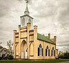 | April 11, 1973 (#73002015) | Junction of 2nd and Church Sts. 39°01′40″N 78°16′39″W / 39.027639°N 78.277500°W / 39.027639; -78.277500 (St. Thomas Chapel) | Middletown | |
23 | Springdale | 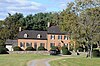 | November 22, 2016 (#16000797) | 1663 Apple Pie Ridge Rd. 39°15′26″N 78°10′53″W / 39.257361°N 78.181389°W / 39.257361; -78.181389 (Springdale) | Winchester | |
24 | Springdale Mill Complex | 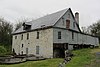 | July 8, 1982 (#82004559) | U.S. Route 11 39°06′36″N 78°12′21″W / 39.110000°N 78.205833°W / 39.110000; -78.205833 (Springdale Mill Complex) | Bartonsville | Limestone flour mill on Opequon Creek built in 1788.[10] |
25 | Sunrise |  | February 8, 1995 (#95000021) | 975 Hollow Rd. 39°15′54″N 78°22′27″W / 39.265000°N 78.374167°W / 39.265000; -78.374167 (Sunrise) | Gore | |
26 | Thorndale Farm |  | August 15, 2016 (#16000528) | 652 N. Buckton Rd. 39°01′56″N 78°15′31″W / 39.032361°N 78.258611°W / 39.032361; -78.258611 (Thorndale Farm) | Middletown | |
27 | Valley Mill Farm |  | February 9, 2006 (#06000032) | 1494 Valley Mill Rd. 39°10′46″N 78°05′10″W / 39.179444°N 78.086111°W / 39.179444; -78.086111 (Valley Mill Farm) | Winchester | |
28 | Willow Shade |  | December 18, 1990 (#90001925) | Junction of U.S. Route 50 and Stony Hill Rd. 39°16′07″N 78°18′29″W / 39.268611°N 78.308056°W / 39.268611; -78.308056 (Willow Shade) | Winchester |
See also[edit]
| Wikimedia Commons has media related to National Register of Historic Places in Frederick County, Virginia. |
- List of National Historic Landmarks in Virginia
- National Register of Historic Places listings in Virginia
- National Register of Historic Places listings in Winchester, Virginia
References[edit]
^ The latitude and longitude information provided in this table was derived originally from the National Register Information System, which has been found to be fairly accurate for about 99% of listings. For about 1% of NRIS original coordinates, experience has shown that one or both coordinates are typos or otherwise extremely far off; some corrections may have been made. A more subtle problem causes many locations to be off by up to 150 yards, depending on location in the country: most NRIS coordinates were derived from tracing out latitude and longitudes from USGS topographical quadrant maps created under the North American Datum of 1927, which differs from the current, highly accurate WGS84 GPS system used by most on-line maps. Chicago is about right, but NRIS longitudes in Washington are higher by about 4.5 seconds, and are lower by about 2.0 seconds in Maine. Latitudes differ by about 1.0 second in Florida. Some locations in this table may have been corrected to current GPS standards.
^ "National Register of Historic Places: Weekly List Actions". National Park Service, United States Department of the Interior. Retrieved on November 2, 2018.
^ Numbers represent an ordering by significant words. Various colorings, defined here, differentiate National Historic Landmarks and historic districts from other NRHP buildings, structures, sites or objects.
^ National Park Service (2008-04-24). "National Register Information System". National Register of Historic Places. National Park Service..mw-parser-output cite.citationfont-style:inherit.mw-parser-output qquotes:"""""""'""'".mw-parser-output code.cs1-codecolor:inherit;background:inherit;border:inherit;padding:inherit.mw-parser-output .cs1-lock-free abackground:url("//upload.wikimedia.org/wikipedia/commons/thumb/6/65/Lock-green.svg/9px-Lock-green.svg.png")no-repeat;background-position:right .1em center.mw-parser-output .cs1-lock-limited a,.mw-parser-output .cs1-lock-registration abackground:url("//upload.wikimedia.org/wikipedia/commons/thumb/d/d6/Lock-gray-alt-2.svg/9px-Lock-gray-alt-2.svg.png")no-repeat;background-position:right .1em center.mw-parser-output .cs1-lock-subscription abackground:url("//upload.wikimedia.org/wikipedia/commons/thumb/a/aa/Lock-red-alt-2.svg/9px-Lock-red-alt-2.svg.png")no-repeat;background-position:right .1em center.mw-parser-output .cs1-subscription,.mw-parser-output .cs1-registrationcolor:#555.mw-parser-output .cs1-subscription span,.mw-parser-output .cs1-registration spanborder-bottom:1px dotted;cursor:help.mw-parser-output .cs1-hidden-errordisplay:none;font-size:100%.mw-parser-output .cs1-visible-errorfont-size:100%.mw-parser-output .cs1-subscription,.mw-parser-output .cs1-registration,.mw-parser-output .cs1-formatfont-size:95%.mw-parser-output .cs1-kern-left,.mw-parser-output .cs1-kern-wl-leftpadding-left:0.2em.mw-parser-output .cs1-kern-right,.mw-parser-output .cs1-kern-wl-rightpadding-right:0.2em
^ The eight-digit number below each date is the number assigned to each location in the National Register Information System database, which can be viewed by clicking the number.
^ "Winchester-Frederick County Historical Society". Abram's Delight. Winchester-Frederick County Historical Society. Archived from the original on 11 December 2014. Retrieved 20 May 2012.
^ "NRHP Registration Form: Monte Vista" (PDF). Virginia Department of Historic Resources. Retrieved 20 May 2012.
^ "NRHP Registration Form: Old Forge Farm" (PDF). Virginia Department of Historic Resources. Archived from the original (PDF) on 12 May 2008. Retrieved 20 May 2012.
^ "Our History". Opequon Presbyterian Church. Retrieved 20 May 2012.
^ "Springdale Mill Complex". Archiplanet. Retrieved 20 May 2012.
U.S. National Register of Historic Places in Virginia | ||
|---|---|---|
| Lists by county |
|   |
| Lists by city |
| |
| Other lists |
| |
| ||
Municipalities and communities of Frederick County, Virginia, United States | ||
|---|---|---|
County seat: Winchester | ||
| Towns |
|  |
| CDPs |
| |
| Unincorporated communities |
| |
Categories:
- National Register of Historic Places in Frederick County, Virginia
- Lists of National Register of Historic Places in Virginia by county
(window.RLQ=window.RLQ||).push(function()mw.config.set("wgPageParseReport":"limitreport":"cputime":"0.664","walltime":"0.803","ppvisitednodes":"value":11934,"limit":1000000,"ppgeneratednodes":"value":0,"limit":1500000,"postexpandincludesize":"value":232207,"limit":2097152,"templateargumentsize":"value":17456,"limit":2097152,"expansiondepth":"value":11,"limit":40,"expensivefunctioncount":"value":0,"limit":500,"unstrip-depth":"value":1,"limit":20,"unstrip-size":"value":18983,"limit":5000000,"entityaccesscount":"value":1,"limit":400,"timingprofile":["100.00% 468.192 1 -total"," 55.13% 258.108 28 Template:NRHP_row"," 19.62% 91.873 1 Template:NRHP_header"," 18.71% 87.618 6 Template:Cite_web"," 15.03% 70.352 1 Template:NRISref"," 10.80% 50.549 29 Template:Designation/color"," 10.53% 49.312 56 Template:First_word"," 10.10% 47.287 30 Template:NRHP_color"," 10.05% 47.057 28 Template:Coord"," 8.61% 40.309 1 Template:Reflist"],"scribunto":"limitreport-timeusage":"value":"0.183","limit":"10.000","limitreport-memusage":"value":6483564,"limit":52428800,"cachereport":"origin":"mw1301","timestamp":"20181111231000","ttl":1900800,"transientcontent":false);mw.config.set("wgBackendResponseTime":80,"wgHostname":"mw1323"););


