National Register of Historic Places listings in Brunswick County, Virginia
[dummy-text]
National Register of Historic Places listings in Brunswick County, Virginia
Jump to navigation
Jump to search

Location of Brunswick County in Virginia
This is a list of the National Register of Historic Places listings in Brunswick County, Virginia.
This is intended to be a complete list of the properties and districts on the National Register of Historic Places in Brunswick County, Virginia, United States. The locations of National Register properties and districts for which the latitude and longitude coordinates are included below, may be seen in a Google map.[1]
There are 11 properties and districts listed on the National Register in the county. Another property was once listed but has been removed.
This National Park Service list is complete through NPS recent listings posted November 2, 2018.[2]
Current listings[edit]
| [3] | Name on the Register[4] | Image | Date listed[5] | Location | City or town | Description |
|---|---|---|---|---|---|---|
1 | Brick House | 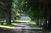 | July 8, 1982 (#82004544) | Brodnax Rd. 36°38′58″N 77°59′14″W / 36.649444°N 77.987222°W / 36.649444; -77.987222 (Brick House) | White Plains | |
2 | Brunswick County Courthouse Square | 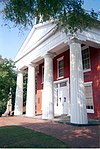 | December 31, 1974 (#74002110) | 202, 216, 228, and 234 N. Main St. 36°45′31″N 77°50′48″W / 36.758611°N 77.846667°W / 36.758611; -77.846667 (Brunswick County Courthouse Square) | Lawrenceville | |
3 | Church Home for Aged, Infirm and Disabled Colored People | 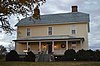 | August 26, 2004 (#04000910) | 236 Pleasant Grove Rd. 36°44′47″N 77°52′52″W / 36.746389°N 77.881111°W / 36.746389; -77.881111 (Church Home for Aged, Infirm and Disabled Colored People) | Brodnax | |
4 | Fort Christanna |  | July 16, 1980 (#80004175) | Fort Hill Rd. southwest of Lawrenceville[6] 36°42′48″N 77°52′15″W / 36.713333°N 77.870833°W / 36.713333; -77.870833 (Fort Christanna) | Lawrenceville | |
5 | Gholson Bridge | 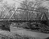 | May 5, 1978 (#78003010) | South of Lawrenceville on Iron Bridge Rd., over the Meherrin River 36°43′01″N 77°49′52″W / 36.716944°N 77.831222°W / 36.716944; -77.831222 (Gholson Bridge) | Lawrenceville | |
6 | Hobson's Choice |  | March 18, 1980 (#80004174) | East of Alberta on Old Bridge Rd. 36°52′19″N 77°48′58″W / 36.872083°N 77.816111°W / 36.872083; -77.816111 (Hobson's Choice) | Alberta | |
7 | Lawrenceville Historic District |  | April 13, 2000 (#00000313) | Roughly bounded by W. 6th Ave., Maria St., the Lawrenceville town line, Rose Creek, and Thomas St. 36°45′29″N 77°50′50″W / 36.758056°N 77.847222°W / 36.758056; -77.847222 (Lawrenceville Historic District) | Lawrenceville | |
8 | Mason-Tillett House |  | January 16, 2004 (#03001443) | 1050 Christanna Highway 36°33′33″N 77°48′13″W / 36.559028°N 77.803611°W / 36.559028; -77.803611 (Mason-Tillett House) | Valentines | |
9 | Rocky Run Methodist Church | 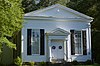 | July 7, 1995 (#95000828) | Lew Jones Rd., 1.8 miles (2.9 km) east of its junction with State Route 46 36°55′55″N 77°56′21″W / 36.931944°N 77.939167°W / 36.931944; -77.939167 (Rocky Run Methodist Church) | Alberta | |
10 | St. Paul's College | 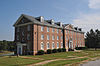 | June 27, 1979 (#79003032) | St. Paul's College campus 36°45′40″N 77°50′59″W / 36.761111°N 77.849722°W / 36.761111; -77.849722 (St. Paul's College) | Lawrenceville | |
11 | St. Paul's School | 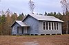 | June 4, 2004 (#04000037) | Brunswick Dr. at Interstate 85 36°49′31″N 77°57′30″W / 36.825278°N 77.958472°W / 36.825278; -77.958472 (St. Paul's School) | Meredithville |
Former listing[edit]
| [3] | Name on the Register | Image | Date listed | Date removed | Location | City or town | Summary |
|---|---|---|---|---|---|---|---|
1 | Bentfield | January 24, 1974 (#74002109) | March 19, 2001 | SW of Lawrenceville off U.S. 58 and VA 656 | Lawrenceville | Destroyed by fire in 1974 |
See also[edit]
| Wikimedia Commons has media related to National Register of Historic Places in Brunswick County, Virginia. |
- List of National Historic Landmarks in Virginia
- National Register of Historic Places listings in Virginia
References[edit]
^ The latitude and longitude information provided in this table was derived originally from the National Register Information System, which has been found to be fairly accurate for about 99% of listings. For about 1% of NRIS original coordinates, experience has shown that one or both coordinates are typos or otherwise extremely far off; some corrections may have been made. A more subtle problem causes many locations to be off by up to 150 yards, depending on location in the country: most NRIS coordinates were derived from tracing out latitude and longitudes from USGS topographical quadrant maps created under the North American Datum of 1927, which differs from the current, highly accurate WGS84 GPS system used by most on-line maps. Chicago is about right, but NRIS longitudes in Washington are higher by about 4.5 seconds, and are lower by about 2.0 seconds in Maine. Latitudes differ by about 1.0 second in Florida. Some locations in this table may have been corrected to current GPS standards.
^ "National Register of Historic Places: Weekly List Actions". National Park Service, United States Department of the Interior. Retrieved on November 2, 2018.
^ ab Numbers represent an ordering by significant words. Various colorings, defined here, differentiate National Historic Landmarks and historic districts from other NRHP buildings, structures, sites or objects.
^ National Park Service (2008-04-24). "National Register Information System". National Register of Historic Places. National Park Service..mw-parser-output cite.citationfont-style:inherit.mw-parser-output qquotes:"""""""'""'".mw-parser-output code.cs1-codecolor:inherit;background:inherit;border:inherit;padding:inherit.mw-parser-output .cs1-lock-free abackground:url("//upload.wikimedia.org/wikipedia/commons/thumb/6/65/Lock-green.svg/9px-Lock-green.svg.png")no-repeat;background-position:right .1em center.mw-parser-output .cs1-lock-limited a,.mw-parser-output .cs1-lock-registration abackground:url("//upload.wikimedia.org/wikipedia/commons/thumb/d/d6/Lock-gray-alt-2.svg/9px-Lock-gray-alt-2.svg.png")no-repeat;background-position:right .1em center.mw-parser-output .cs1-lock-subscription abackground:url("//upload.wikimedia.org/wikipedia/commons/thumb/a/aa/Lock-red-alt-2.svg/9px-Lock-red-alt-2.svg.png")no-repeat;background-position:right .1em center.mw-parser-output .cs1-subscription,.mw-parser-output .cs1-registrationcolor:#555.mw-parser-output .cs1-subscription span,.mw-parser-output .cs1-registration spanborder-bottom:1px dotted;cursor:help.mw-parser-output .cs1-hidden-errordisplay:none;font-size:100%.mw-parser-output .cs1-visible-errorfont-size:100%.mw-parser-output .cs1-subscription,.mw-parser-output .cs1-registration,.mw-parser-output .cs1-formatfont-size:95%.mw-parser-output .cs1-kern-left,.mw-parser-output .cs1-kern-wl-leftpadding-left:0.2em.mw-parser-output .cs1-kern-right,.mw-parser-output .cs1-kern-wl-rightpadding-right:0.2em
^ The eight-digit number below each date is the number assigned to each location in the National Register Information System database, which can be viewed by clicking the number.
^ PCT07A: Fort Christanna Historical Site, Virginia Department of Game & Inland Fisheries, 2017. Accessed 2017-01-03.
U.S. National Register of Historic Places in Virginia | ||
|---|---|---|
| Lists by county |
|   |
| Lists by city |
| |
| Other lists |
| |
| ||
Municipalities and communities of Brunswick County, Virginia, United States | ||
|---|---|---|
County seat: Lawrenceville | ||
| Towns |
|  |
| CDPs |
| |
| Unincorporated communities |
| |
| Footnotes | ‡This populated place also has portions in an adjacent county or counties | |
Categories:
- National Register of Historic Places in Brunswick County, Virginia
- Lists of National Register of Historic Places in Virginia by county
(window.RLQ=window.RLQ||).push(function()mw.config.set("wgPageParseReport":"limitreport":"cputime":"0.468","walltime":"0.601","ppvisitednodes":"value":5719,"limit":1000000,"ppgeneratednodes":"value":0,"limit":1500000,"postexpandincludesize":"value":141749,"limit":2097152,"templateargumentsize":"value":10314,"limit":2097152,"expansiondepth":"value":11,"limit":40,"expensivefunctioncount":"value":0,"limit":500,"unstrip-depth":"value":1,"limit":20,"unstrip-size":"value":6213,"limit":5000000,"entityaccesscount":"value":1,"limit":400,"timingprofile":["100.00% 375.957 1 -total"," 42.20% 158.669 12 Template:NRHP_row"," 27.54% 103.551 1 Template:NRHP_header"," 19.97% 75.096 1 Template:NRISref"," 18.69% 70.252 1 Template:Cite_web"," 9.16% 34.452 13 Template:Designation/color"," 8.90% 33.475 23 Template:NRHP_color"," 8.04% 30.234 1 Template:Convert"," 7.59% 28.521 1 Template:Commons_category"," 7.48% 28.116 2 Template:Navbox"],"scribunto":"limitreport-timeusage":"value":"0.113","limit":"10.000","limitreport-memusage":"value":4291984,"limit":52428800,"cachereport":"origin":"mw1338","timestamp":"20181111225808","ttl":1900800,"transientcontent":false);mw.config.set("wgBackendResponseTime":93,"wgHostname":"mw1333"););


