Arco, Idaho

 Clash Royale CLAN TAG#URR8PPP
| Arco, Idaho | |
|---|---|
| City | |
 | |
 Location of Arco in Butte County, Idaho. | |
 Arco, Idaho Location in the United States | |
| Coordinates: 43°38′5″N 113°18′5″W / 43.63472°N 113.30139°W / 43.63472; -113.30139Coordinates: 43°38′5″N 113°18′5″W / 43.63472°N 113.30139°W / 43.63472; -113.30139 | |
| Country | United States |
| State | Idaho |
| County | Butte |
| Area[1] | |
| • Total | 1.08 sq mi (2.80 km2) |
| • Land | 1.07 sq mi (2.77 km2) |
| • Water | 0.01 sq mi (0.03 km2) |
| Elevation | 5,325 ft (1,623 m) |
| Population (2010)[2] | |
| • Total | 995 |
| • Estimate (2016)[3] | 849 |
| • Density | 794.94/sq mi (306.81/km2) |
| Time zone | UTC-7 (Mountain (MST)) |
| • Summer (DST) | UTC-6 (MDT) |
| ZIP code | 83213 |
| Area code(s) | 208 |
| FIPS code | 16-03160 |
GNIS feature ID | 0396049 |
Arco is a city in Butte County, Idaho, United States. The population was 995 at the 2010 census.[4] Arco is the county seat and largest city in Butte County.[5]
Arco is located along the Big Lost River and is a gateway to the Lost River Range from the Snake River Plain.
Craters of the Moon National Monument is located along U.S. Route 20, southwest of the city. The Idaho National Laboratory (INL) is located east of Arco.
Contents
1 History
2 Economy
3 Highways
4 Geography
5 Demographics
5.1 2010 census
5.2 2000 census
6 Notable residents
7 See also
8 References
9 External links
History
Originally known as Root Hog, the original town site was five miles (8 km) south at the junction of two stagecoach lines (Blackfoot-Wood River and Blackfoot-Salmon). A suspension bridge that crossed the Big Lost River funneled traffic through the settlement. The town leaders applied to the U.S. Post Office for the town name of "Junction".
The Postmaster General thought the name too common and suggested that the place be named Arco for Georg von Arco (1869–1940) of Germany who was visiting Washington, D.C. at the time. Georg von Arco was an inventor and a pioneer in the field of radio transmission and would become the lead engineer of Telefunken, a German company founded in 1903 that produced radio vacuum tubes. The town later moved four miles southeast when the stage station was moved to Webb Springs at Big Southern Butte. When the Oregon Short Line Railroad arrived from Blackfoot in 1901 the stage lines became obsolete and the town of Arco moved northwest to its present site.[6]
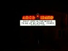
Arco was the first community in the world ever to be lit by electricity generated solely by nuclear power. This occurred for about an hour on July 17, 1955, powered by Argonne National Laboratory’s BORAX-III reactor at the nearby National Reactor Testing Station (NRTS), which eventually became the site of the Idaho National Energy Laboratory, a predecessor of the current Idaho National Laboratory.[7] NRTS made further history on January 3, 1961, when the SL-1 reactor was destroyed through an operator maintenance error, with the ensuing steam explosion causing the deaths of all three personnel present. It was the world's first and the United States' only fatal reactor accident.[8]
Economy
The town's economic base is primarily derived from the Idaho National Laboratory (formerly the Idaho National Engineering Laboratory or INEL), agricultural products, and recreation in the Lost River Valley.
Highways
 US 20 — to Mountain Home (west) and Idaho Falls (east)
 US 26 — to Shoshone (west) and Blackfoot (east)
 US 93 — to Challis (north) and Twin Falls (south)
Geography
Arco is located at 43°38′5″N 113°18′5″W / 43.63472°N 113.30139°W / 43.63472; -113.30139 (43.634632, -113.301323).[9] The elevation is 5325 feet (1623 m) above sea level.
According to the United States Census Bureau, the city has a total area of 1.07 square miles (2.77 km2), of which, 1.06 square miles (2.75 km2) is land and 0.01 square miles (0.03 km2) is water.[10]
In town, the most striking physical feature is Number Hill, a rocky hill with numbers painted all over it. Butte County High School has a tradition of each class since 1920 painting its graduation year on the face of hill.[11]
| Climate data for Arco, Idaho (1971–2000) | |||||||||||||
|---|---|---|---|---|---|---|---|---|---|---|---|---|---|
| Month | Jan | Feb | Mar | Apr | May | Jun | Jul | Aug | Sep | Oct | Nov | Dec | Year |
| Average high °F (°C) | 29.5 (−1.4) | 35.5 (1.9) | 45.7 (7.6) | 58.1 (14.5) | 67.0 (19.4) | 76.6 (24.8) | 84.6 (29.2) | 83.2 (28.4) | 73.6 (23.1) | 61.1 (16.2) | 41.9 (5.5) | 30.4 (−0.9) | 57.3 (14.1) |
| Average low °F (°C) | 4.8 (−15.1) | 9.6 (−12.4) | 20.7 (−6.3) | 28.8 (−1.8) | 36.6 (2.6) | 43.4 (6.3) | 48.4 (9.1) | 47.0 (8.3) | 38.0 (3.3) | 29.0 (−1.7) | 17.6 (−8) | 6.2 (−14.3) | 27.5 (−2.5) |
| Average precipitation inches (mm) | 0.82 (20.8) | 1.05 (26.7) | 0.86 (21.8) | 0.75 (19) | 1.32 (33.5) | 0.90 (22.9) | 0.83 (21.1) | 0.78 (19.8) | 0.70 (17.8) | 0.63 (16) | 0.80 (20.3) | 0.81 (20.6) | 10.25 (260.3) |
| Source: NOAA (normals, 1971–2000) [12] | |||||||||||||
Demographics
| Historical population | |||
|---|---|---|---|
| Census | Pop. | %± | |
| 1910 | 322 | — | |
| 1920 | 737 | 128.9% | |
| 1930 | 572 | −22.4% | |
| 1940 | 548 | −4.2% | |
| 1950 | 961 | 75.4% | |
| 1960 | 1,562 | 62.5% | |
| 1970 | 1,244 | −20.4% | |
| 1980 | 1,241 | −0.2% | |
| 1990 | 1,016 | −18.1% | |
| 2000 | 1,026 | 1.0% | |
| 2010 | 995 | −3.0% | |
| Est. 2016 | 849 | [3] | −14.7% |
| U.S. Decennial Census[13] | |||
2010 census
As of the 2010 United States Census[2] of 2010, there were 995 people, 417 households, and 254 families residing in the city. The population density was 938.7 inhabitants per square mile (362.4/km2). There were 504 housing units at an average density of 475.5 per square mile (183.6/km2). The racial makeup of the city was 95.1% White, 0.3% Native American, 0.3% Asian, 1.7% from other races, and 2.6% from two or more races. Hispanic or Latino of any race were 3.0% of the population.
There were 417 households of which 30.2% had children under the age of 18 living with them, 44.4% were married couples living together, 13.2% had a female householder with no husband present, 3.4% had a male householder with no wife present, and 39.1% were non-families. 34.1% of all households were made up of individuals and 15.9% had someone living alone who was 65 years of age or older. The average household size was 2.35 and the average family size was 3.03.
The median age in the city was 41.2 years. 26.9% of residents were under the age of 18; 6.1% were between the ages of 18 and 24; 21.6% were from 25 to 44; 26.1% were from 45 to 64; and 18.9% were 65 years of age or older. The gender makeup of the city was 51.8% male and 48.2% female.
2000 census
As of the 2000 United States Census[14] of 2000, there were 1,026 people, 427 households, and 269 families residing in the city. The population density was 1,163.9 people per square mile (450.2/km²). There were 505 housing units at an average density of 572.9 per square mile (221.6/km²). The racial makeup of the city was 95.13% White, 0.49% African American, 1.36% Native American, 1.75% from other races, and 1.27% from two or more races. Hispanic or Latino of any race were 3.61% of the population.

City office / Recreation Hall
on Main Street in Arco
There were 427 households out of which 29.3% had children under the age of 18 living with them, 48.2% were married couples living together, 11.9% had a female householder with no husband present, and 37.0% were non-families. 34.0% of all households were made up of individuals and 15.2% had someone living alone who was 65 years of age or older. The average household size was 2.35 and the average family size was 3.04.
In the city, the population was spread out with 27.9% under the age of 18, 6.8% from 18 to 24, 22.4% from 25 to 44, 25.8% from 45 to 64, and 17.1% who were 65 years of age or older. The median age was 40 years. For every 100 females, there were 91.8 males. For every 100 females age 18 and over, there were 90.7 males.
The median income for a household in the city was $27,993, and the median income for a family was $34,688. Males had a median income of $34,688 versus $17,386 for females. The per capita income for the city was $14,744. About 19.6% of families and 22.6% of the population were below the poverty line, including 33.8% of those under age 18 and 15.8% of those age 65 or over.
Notable residents
C. A. Bottolfsen, Governor of Idaho, (1939–1941, 1943–1945)
Warren Jones — justice, Idaho Supreme Court, valedictorian of Butte County High School in 1961
See also
 Play media
Atomic power neon sign at night.
City of Arco Recreation Hall
- Idaho National Laboratory
- Borah Peak
- Lost River Range
- Big Lost River
- Salmon-Challis National Forest
- Snake River Plain
- Craters of the Moon National Monument and Preserve
- Big Southern Butte
- Blizzard Mountain Ski Area
- Butte County High School
References
^ "2016 U.S. Gazetteer Files". United States Census Bureau. Retrieved Jul 26, 2017..mw-parser-output cite.citationfont-style:inherit.mw-parser-output qquotes:"""""""'""'".mw-parser-output code.cs1-codecolor:inherit;background:inherit;border:inherit;padding:inherit.mw-parser-output .cs1-lock-free abackground:url("//upload.wikimedia.org/wikipedia/commons/thumb/6/65/Lock-green.svg/9px-Lock-green.svg.png")no-repeat;background-position:right .1em center.mw-parser-output .cs1-lock-limited a,.mw-parser-output .cs1-lock-registration abackground:url("//upload.wikimedia.org/wikipedia/commons/thumb/d/d6/Lock-gray-alt-2.svg/9px-Lock-gray-alt-2.svg.png")no-repeat;background-position:right .1em center.mw-parser-output .cs1-lock-subscription abackground:url("//upload.wikimedia.org/wikipedia/commons/thumb/a/aa/Lock-red-alt-2.svg/9px-Lock-red-alt-2.svg.png")no-repeat;background-position:right .1em center.mw-parser-output .cs1-subscription,.mw-parser-output .cs1-registrationcolor:#555.mw-parser-output .cs1-subscription span,.mw-parser-output .cs1-registration spanborder-bottom:1px dotted;cursor:help.mw-parser-output .cs1-hidden-errordisplay:none;font-size:100%.mw-parser-output .cs1-visible-errorfont-size:100%.mw-parser-output .cs1-subscription,.mw-parser-output .cs1-registration,.mw-parser-output .cs1-formatfont-size:95%.mw-parser-output .cs1-kern-left,.mw-parser-output .cs1-kern-wl-leftpadding-left:0.2em.mw-parser-output .cs1-kern-right,.mw-parser-output .cs1-kern-wl-rightpadding-right:0.2em
^ ab "American FactFinder". United States Census Bureau. Retrieved 2012-12-18.
^ ab "Population and Housing Unit Estimates". Retrieved June 9, 2017.
^ U.S. Census Bureau, 2010 Census Redistricting Data (Public Law 94-171) Summary File: Arco, Idaho. From American FactFinder Archived September 11, 2013, at the Wayback Machine.
^ "Find a County". National Association of Counties. Archived from the original on 2011-05-31. Retrieved 2011-06-07.
^ "Idaho for the Curious", by Cort Conley, ©1982,
ISBN 0-9603566-3-0, p.534
^ "AEC Press release for BORAX-III lighting Arco, Idaho". United States Department of Energy, Argonne National Laboratory. 1999. Retrieved 2012-07-26.
^ See List of nuclear power accidents by country.
^ "US Gazetteer files: 2010, 2000, and 1990". United States Census Bureau. 2011-02-12. Retrieved 2011-04-23.
^ "US Gazetteer files 2010". United States Census Bureau. Archived from the original on 2012-01-24. Retrieved 2012-12-18.
^ Gallery Fifty Eight: Man and nature -- Number Hill, Arco, Idaho, 2010 Retrieved 2014-09-28. Photo of Number Hill shown.
^ "Climatography of the United States NO.81" (PDF). National Oceanic and Atmospheric Administration. Retrieved January 13, 2011.
^ "Census of Population and Housing". Census.gov. Archived from the original on May 12, 2015. Retrieved June 4, 2015.
^ "American FactFinder". United States Census Bureau. Archived from the original on 2013-09-11. Retrieved 2008-01-31.
External links
| Wikivoyage has a travel guide for Arco (Idaho). |
- 1949 Life Magazine Photos
Municipalities and communities of Butte County, Idaho, United States | ||
|---|---|---|
County seat: Arco | ||
| Cities |
| |
| Unincorporated community |
| |