Kanchanaburi

 Clash Royale CLAN TAG#URR8PPP
Kanchanaburi กาญจนบุรี | |
|---|---|
Town | |
 Kanchanaburi Bus Terminal | |
 Kanchanaburi Location in Thailand | |
| Coordinates: 14°1′10″N 99°31′52″E / 14.01944°N 99.53111°E / 14.01944; 99.53111 | |
| Country | Thailand |
| Province | Kanchanaburi Province |
| District | Mueang Kanchanaburi District |
| Elevation | 100 ft (30 m) |
| Population (2006) | |
| • Total | 31,327 |
| Time zone | UTC+7 (ICT) |
Kanchanaburi (Thai: กาญจนบุรี, pronounced [kāːn.t͡ɕā.ná(ʔ).bū.rīː]) is a town municipality (thesaban mueang) in the west of Thailand and part of Kanchanaburi Province. In 2006 it had a population of 31,327. The town covers tambons Ban Nuea and Ban Tai and parts of Pak Phraek and Tha Makham, all of Mueang Kanchanaburi District, and parts of tambon Tha Lo of Tha Muang District. Kanchanaburi lies 123 km west of Bangkok.[1]
Contents
1 History
2 Geography
2.1 Climate
3 Location
4 Buddhism
5 Death railway
6 See also
7 References
8 External links
History
In the late-18th century, Kanchanaburi was established by King Rama I as a defensive outpost against possible Burmese attacks in what is now Lat Ya Sub-district. In 1833, the town was moved about 16 km to the southeast along the river to its present site during the reign of King Rama III.[2]
Geography
Climate
Kanchanaburi has a tropical savanna climate (Köppen climate classification Aw). Winters are dry and very warm. Temperatures rise until April, which is very hot with the average daily maximum at 38.2 °C (100.8 °F). The monsoon season runs from May through October, with heavy rain and somewhat cooler temperatures during the day, although nights remain warm.
| Climate data for Kanchanaburi (1981–2010) | |||||||||||||
|---|---|---|---|---|---|---|---|---|---|---|---|---|---|
| Month | Jan | Feb | Mar | Apr | May | Jun | Jul | Aug | Sep | Oct | Nov | Dec | Year |
| Record high °C (°F) | 38.4 (101.1) | 40.8 (105.4) | 42.1 (107.8) | 43.5 (110.3) | 42.8 (109.0) | 40.6 (105.1) | 39.7 (103.5) | 39.4 (102.9) | 39.8 (103.6) | 36.0 (96.8) | 38.0 (100.4) | 36.4 (97.5) | 43.5 (110.3) |
| Average high °C (°F) | 33.0 (91.4) | 35.6 (96.1) | 37.3 (99.1) | 38.2 (100.8) | 35.9 (96.6) | 34.5 (94.1) | 33.9 (93.0) | 33.6 (92.5) | 33.6 (92.5) | 32.2 (90.0) | 31.6 (88.9) | 31.3 (88.3) | 34.2 (93.6) |
| Daily mean °C (°F) | 26.0 (78.8) | 28.0 (82.4) | 29.7 (85.5) | 31.0 (87.8) | 29.7 (85.5) | 29.0 (84.2) | 28.6 (83.5) | 28.4 (83.1) | 28.0 (82.4) | 27.3 (81.1) | 26.4 (79.5) | 24.9 (76.8) | 28.1 (82.6) |
| Average low °C (°F) | 19.9 (67.8) | 22.1 (71.8) | 24.2 (75.6) | 25.9 (78.6) | 25.8 (78.4) | 25.5 (77.9) | 25.1 (77.2) | 25.1 (77.2) | 24.6 (76.3) | 23.9 (75.0) | 22.2 (72.0) | 19.6 (67.3) | 23.7 (74.7) |
| Record low °C (°F) | 10.5 (50.9) | 14.1 (57.4) | 13.9 (57.0) | 21.4 (70.5) | 21.5 (70.7) | 22.9 (73.2) | 21.1 (70.0) | 22.2 (72.0) | 20.2 (68.4) | 17.0 (62.6) | 12.4 (54.3) | 9.2 (48.6) | 9.2 (48.6) |
| Average rainfall mm (inches) | 3.3 (0.13) | 18.2 (0.72) | 29.0 (1.14) | 78.5 (3.09) | 145.3 (5.72) | 86.4 (3.40) | 102.9 (4.05) | 98.3 (3.87) | 220.5 (8.68) | 209.2 (8.24) | 58.6 (2.31) | 6.2 (0.24) | 1,056.4 (41.59) |
| Average rainy days | 0.8 | 1.6 | 3.2 | 5.7 | 13.7 | 14.4 | 15.7 | 16.1 | 18.1 | 15.1 | 5.0 | 1.2 | 110.6 |
| Average relative humidity (%) | 64 | 62 | 61 | 63 | 71 | 72 | 73 | 74 | 77 | 80 | 73 | 66 | 70 |
| Mean monthly sunshine hours | 263.5 | 245.8 | 238.7 | 240.0 | 155.0 | 114.0 | 117.8 | 117.8 | 108.0 | 145.7 | 186.0 | 260.4 | 2,192.7 |
| Mean daily sunshine hours | 8.5 | 8.7 | 7.7 | 8.0 | 5.0 | 3.8 | 3.8 | 3.8 | 3.6 | 4.7 | 6.2 | 8.4 | 6.0 |
| Source #1: Thai Meteorological Department[3] | |||||||||||||
| Source #2: Office of Water Management and Hydrology, Royal Irrigation Department (sun and humidity)[4] | |||||||||||||
Location
Kanchanaburi, where the Khwae Noi and Khwae Yai Rivers converge into the Mae Klong River, spans the northern banks of the river and is a popular spot for travelers. Its location at the edge of a mountain range keeps it much cooler than the other provinces of central Thailand. The city has two major commercial districts: the downtown area consists of a grid of several streets with office buildings, shop fronts, and a shopping mall; and the riverfront area businesses are mostly further west along River Kwai Road. Once a year a carnival comes to town and is set up in the area next to the bridge. At night there is a small pyrotechnics display that re-enacts the wartime bombing of the bridge.
Buddhism
Kanchanaburi is the birthplace of the Buddhist monk Phrabhavanaviriyakhun. It is 5 kilometres (3.1 mi) southeast of the Buddhist temple Wat Tham Phu Wa which features a series of grotto shrines within a large limestone cave system. Each grotto features a statue of the Buddha at a different stage of his life. It is the easiest access point to the nearby Tiger Temple and is also home to a Vipassana meditation center.
Death railway
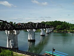
The Bridge over the River Kwai
In 1942 Kanchanaburi was under Japanese control. It was here that Asian forced labourers and Allied POWs, building the infamous Burma Railway, constructed a bridge, an event portrayed in the films The Bridge on the River Kwai (1957), Return from the River Kwai, (1989) and The Railway Man (2013). Almost half of the prisoners working on the project died from disease, maltreatment, or accidents.
At Kanchanaburi, there is a memorial and two museums to commemorate the dead. In March 2003, the Thailand–Burma Railway Centre opened and the JEATH (Japanese-English-American-Australian-Thai-Holland) War Museum dedicated to the bridge and the Death Railway.[5] The city is also home to the Kanchanaburi War Cemetery.[6]
The Chong Kai Allies Cemetery is near Kanchanaburi, about 3 kilometres (1.9 mi) from Wat Tham Phu Wa.
See also
- Mueang Kanchanaburi District
- Beata Mundi Regina
- Kanchanaburi Province
- Kanchanaburi Rajabhat University
Visuttharangsi School, the provincial secondary school of Kanchanaburi
Siam–Burma Death Railway (film) (film)- Kanchanaburi War Cemetery
References
^ "Distance: Bangkok to Kanchanaburi". Google Maps. Retrieved 25 June 2015..mw-parser-output cite.citationfont-style:inherit.mw-parser-output .citation qquotes:"""""""'""'".mw-parser-output .citation .cs1-lock-free abackground:url("//upload.wikimedia.org/wikipedia/commons/thumb/6/65/Lock-green.svg/9px-Lock-green.svg.png")no-repeat;background-position:right .1em center.mw-parser-output .citation .cs1-lock-limited a,.mw-parser-output .citation .cs1-lock-registration abackground:url("//upload.wikimedia.org/wikipedia/commons/thumb/d/d6/Lock-gray-alt-2.svg/9px-Lock-gray-alt-2.svg.png")no-repeat;background-position:right .1em center.mw-parser-output .citation .cs1-lock-subscription abackground:url("//upload.wikimedia.org/wikipedia/commons/thumb/a/aa/Lock-red-alt-2.svg/9px-Lock-red-alt-2.svg.png")no-repeat;background-position:right .1em center.mw-parser-output .cs1-subscription,.mw-parser-output .cs1-registrationcolor:#555.mw-parser-output .cs1-subscription span,.mw-parser-output .cs1-registration spanborder-bottom:1px dotted;cursor:help.mw-parser-output .cs1-ws-icon abackground:url("//upload.wikimedia.org/wikipedia/commons/thumb/4/4c/Wikisource-logo.svg/12px-Wikisource-logo.svg.png")no-repeat;background-position:right .1em center.mw-parser-output code.cs1-codecolor:inherit;background:inherit;border:inherit;padding:inherit.mw-parser-output .cs1-hidden-errordisplay:none;font-size:100%.mw-parser-output .cs1-visible-errorfont-size:100%.mw-parser-output .cs1-maintdisplay:none;color:#33aa33;margin-left:0.3em.mw-parser-output .cs1-subscription,.mw-parser-output .cs1-registration,.mw-parser-output .cs1-formatfont-size:95%.mw-parser-output .cs1-kern-left,.mw-parser-output .cs1-kern-wl-leftpadding-left:0.2em.mw-parser-output .cs1-kern-right,.mw-parser-output .cs1-kern-wl-rightpadding-right:0.2em
^ "Thailand Travel Guide for Kanchanaburi". Tourism Authority of Thailand (TAT). Retrieved 2014-08-09.
^ "Climatological Data for the Period 1981–2010". Thai Meteorological Department. p. 16. Retrieved 4 August 2016.
^ "ปริมาณการใช้น้ำของพืชอ้างอิงโดยวิธีของ Penman Monteith (Reference Crop Evapotranspiration by Penman Monteith)" (PDF) (in Thai). Office of Water Management and Hydrology, Royal Irrigation Department. p. 77. Retrieved 4 August 2016.
^ "The Jeath War Museum". Tourism Authority of Thailand (TAT). Archived from the original on 26 June 2015. Retrieved 18 May 2015.
^ "Kanchanaburi War Cemetery (Don Rak)". Tourism Authority of Thailand (TAT). Archived from the original on 15 June 2012. Retrieved 18 May 2015.
External links
 Kanchanaburi travel guide from Wikivoyage
| Wikimedia Commons has media related to Kanchanaburi. |
Capitals of provinces of Thailand | ||
|---|---|---|
| ||
Coordinates: 14°1′10″N 99°31′52″E / 14.01944°N 99.53111°E / 14.01944; 99.53111
Authority control |
|
|---|
