Ōita Station
Ōita Station 大分駅 | |
|---|---|
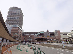 Ōita Station (2015) | |
| Location | 1-1 Kanamemachi, Ōita, Ōita (大分市要町1番1号) Japan |
| Operated by | JR Kyūshū |
| Line(s) |
|
| History | |
| Opened | 1911 |
| Traffic | |
| Passengers (FY2016) | 19,165 daily |
| Rank | 4th (among JR Kyushu stations) |
| Location | |
 Ōita Station Location within Japan | |

Sonic LTD Exp are the most common train at this station.
Ōita Station (大分駅, Ōita-eki) is a JR Kyushu railway station located in Ōita, Ōita Prefecture, Japan.
The station opened on November 1, 1911. It has since undergone renovation, reopening in 2012 — the 'main' area of the station is now the southern, rather than the northern, entrance.
Contents
1 Lines
2 Limited Express Trains
3 Layout
4 History
5 Passenger statistics
6 The station in media
7 Environs
8 References
Lines
- Nippō Main Line
- Kyudai Main Line
- Hohi Main Line
Limited Express Trains
Sonic (Hakata - Ōita)
Nichirin (Hakata - Miyazaki)
Yufuin-no-mori, Yufu (Hakata - Beppu)
Trans-Kyushu Limited Express (Beppu - Hitoyoshi)
Layout
There are four side platforms and eight island platforms.
1 | Limited express trains of Nippō Main Line | for Kokura, Hakata and Saiki |
| Local trains of Nippō Main Line | for Tsurusaki and Saiki | |
2 | Limited express trains of Nippō Main Line | for Saiki and Miyazaki |
| Local trains of Nippō Main Line | for Tsurusaki and Saiki | |
3 | Limited express trains of Nippō Main Line | for Kokura and Hakata |
| Local trains of Nippō Main Line | for Beppu and Nakatsu | |
4 • 5 | Nippō Main Line | for Beppu and Nakatsu |
Nippō Main Line | for Saiki and Miyazaki | |
Limited express trains of Hohi Main Line | for Aso and Kumamoto | |
6 • 7 • 8 | Hohi Main Line | for Aso and Kumamoto |
Kyudai Main Line | for Yufuin and Kurume |
The station was under construction to make it elevated. This work was to be finished by 2008 but fell behind schedule. It was completed on March 17, 2012.
History
Japanese Government Railways (JGR) opened the station on 1 November 1911 as the southern terminus of its then Hōshū Main Line (豊州本線) which it had been extending southwards in phases since 1907 when it had acquired the former Kyushu Railway's private track from Kokura south to Usa. Ōita became a through-station on 1 April 1914 when the track was extended further south to Kōzaki. On 15 December 1923, this entire stretch of track was redesignated as the Nippo Main Line.[1]
Separately, on 1 April 1914, JGR opened the Inukai Light Rail Line (犬飼軽便線) from Ōita westwards to Nakahanda. This track later linked up with another built eastwards from Kumamoto and the entire stretch was designated as the Hōhi Main Line on 2 December 1928.[2]
The origin of the third line to serve the station, the Kyudai Main Line lay with the private Daito Railway (大湯鉄道) which opened a track from Ōita westwards to Onoya on 30 October 1915. On 1 December 1922, the Daito Railway was nationalized and JGR designated this stretch of track as the Daito Line. By 1934, the track had linked up with a track built eastwards from Kurume and the entire route was designated the Kyudai Main Line.[3]
With the privatization of Japanese National Railways (JNR), the successor of JGR, on 1 April 1987, Ōita came under the control of JR Kyushu.[4]
Passenger statistics
In fiscal 2016, the station was used by an average of 19,165 passengers daily (boarding passengers only), and it ranked 4th among the busiest stations of JR Kyushu.[5]
The station in media
The JR Ōita City station complex was the main subject of an episode in the NHK World English documentary series Japan Railway Journal. The episode was titled JR Ōita City: The Station Complex that Changed the Game and was first broadcast on 15 February 2018. The episode describes how the station complex, which opened in 2015, contributed to increased ridership at the station and also to the economic revitalization of the surrounding area. The same episode also covered the Bungo-Mori Roundhouse Park, located near Bungo-Mori Station.[6]
Environs

View from the station
- North Entrance
- Oita Prefectural Government Office
- Oita City Hall
Oasis Hiroba 21 and Oita ANA Hotel OASIS Tower- Funai Castle
- Building of Red Brick (Oita Bank)
- Oita Chūō Post Office
- Oita Parco and Oita Daiichi Hotel
- Tokiwa Department Store
- Chūōcho Centporta
- Galleria Takemachi
- Funai 5 Bangai
- Oita Washington Hotel Plaza
- Hotel Hokke Club Oita
- National Route 10
National Route 197 (Chūō-dori main street)- Oita Station Bus Terminal
- South Entrance
- Oita City Museum of Fine Art
- National Route 210
- Oita Toyo Hotel
References
^ Ishino, Tetsu et al. (eds.) (1998). 停車場変遷大事典 国鉄・JR編 [Station Transition Directory - JNR/JR] (in Japanese). I. Tokyo: JTB Corporation. pp. 228–9. ISBN 4533029809.CS1 maint: Extra text: authors list (link) .mw-parser-output cite.citationfont-style:inherit.mw-parser-output qquotes:"""""""'""'".mw-parser-output code.cs1-codecolor:inherit;background:inherit;border:inherit;padding:inherit.mw-parser-output .cs1-lock-free abackground:url("//upload.wikimedia.org/wikipedia/commons/thumb/6/65/Lock-green.svg/9px-Lock-green.svg.png")no-repeat;background-position:right .1em center.mw-parser-output .cs1-lock-limited a,.mw-parser-output .cs1-lock-registration abackground:url("//upload.wikimedia.org/wikipedia/commons/thumb/d/d6/Lock-gray-alt-2.svg/9px-Lock-gray-alt-2.svg.png")no-repeat;background-position:right .1em center.mw-parser-output .cs1-lock-subscription abackground:url("//upload.wikimedia.org/wikipedia/commons/thumb/a/aa/Lock-red-alt-2.svg/9px-Lock-red-alt-2.svg.png")no-repeat;background-position:right .1em center.mw-parser-output .cs1-subscription,.mw-parser-output .cs1-registrationcolor:#555.mw-parser-output .cs1-subscription span,.mw-parser-output .cs1-registration spanborder-bottom:1px dotted;cursor:help.mw-parser-output .cs1-hidden-errordisplay:none;font-size:100%.mw-parser-output .cs1-visible-errorfont-size:100%.mw-parser-output .cs1-subscription,.mw-parser-output .cs1-registration,.mw-parser-output .cs1-formatfont-size:95%.mw-parser-output .cs1-kern-left,.mw-parser-output .cs1-kern-wl-leftpadding-left:0.2em.mw-parser-output .cs1-kern-right,.mw-parser-output .cs1-kern-wl-rightpadding-right:0.2em
^ Ishino, Tetsu et al. (eds.) (1998). 停車場変遷大事典 国鉄・JR編 [Station Transition Directory - JNR/JR] (in Japanese). I. Tokyo: JTB Corporation. p. 228. ISBN 4533029809.CS1 maint: Extra text: authors list (link)
^ Ishino, Tetsu et al. (eds.) (1998). 停車場変遷大事典 国鉄・JR編 [Station Transition Directory - JNR/JR] (in Japanese). I. Tokyo: JTB Corporation. p. 227. ISBN 4533029809.CS1 maint: Extra text: authors list (link)
^ Ishino, Tetsu et al. (eds.) (1998). 停車場変遷大事典 国鉄・JR編 [Station Transition Directory - JNR/JR] (in Japanese). II. Tokyo: JTB Corporation. p. 743. ISBN 4533029809.CS1 maint: Extra text: authors list (link)
^ "駅別乗車人員上位300駅(平成28年度)" [Passengers embarking by station - Top 300 stations (Fiscal 2016)] (PDF). JR Kyushu. 31 July 2017. Retrieved 25 February 2018.
^ "JR Ōita City: The Station Complex that Changed the Game". Japan Railway Journal. 15 February 2018. NHK World.
| Wikimedia Commons has media related to Ōita Station. |
Coordinates: 33°13′58″N 131°36′24″E / 33.23264°N 131.606705°E / 33.23264; 131.606705
This Oita Prefecture railroad station-related article is a stub. You can help Wikipedia by expanding it. |
