Chapare Province
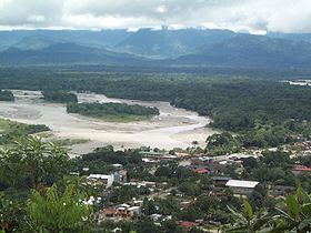 | |
Villa Tunari on Chapare River | |
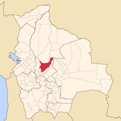
| Location of Chapare Province within Bolivia | |
|---|---|
 | |
| General Data | |
| Country | |
| Department | Cochabamba Department |
| Capital | Sacaba |
| Municipalities | 3 |
| Cantons | 13 |
| Area | 12,445 km² |
| Elevation | m |
| Population | 187,358 (2001) |
| Density | 15.1 inhabitants/km² (2001) |
| Sub-prefect | |
| Languages | Quechua, Spanish, Aymara, Yuracaré |
| ISO 3166-2 | BO.CB.CH |
| Cochabamba Department | |
 | |
Chapare, also called The Chapare and is pronounced Cha-pa-reh, is a rural province in the northern region of Cochabamba Department in central Bolivia. The majority of the territory consists of valley rainforests that surround the area's main waterway, the Chapare River, which is also a tributary of the Amazon River. The provincial capital is Sacaba, 11 km east of Cochabamba, its principal town is Villa Tunari, a popular tourist destination.
In recent decades, the Chapare province has become a haven for illegal cultivation of the coca plant, which can be used to produce cocaine. This is due to Bolivian drug law, which until recently only permitted the Yungas region to legally grow coca, despite Chapare being a historical area for growth due to its fertility. For this reason, Chapare has been a primary target for coca eradication in recent years, with frequent and heated clashes between the U.S. Drug Enforcement Administration and Bolivian cocaleros. The law has since been changed by a deal that was struck between Evo Morales (a former coca activist and current President) and former President Carlos Mesa. This deal permits the region to grow a limited amount of coca every year .
Contents
1 Subdivision
2 Places of interest
3 See also
4 References
5 External links
Subdivision
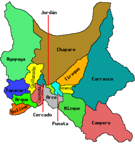
Chapare Province is divided into three municipalities which are further subdivided into cantons.
Section | Municipality | Seat |
|---|---|---|
| 1st | Sacaba Municipality | Sacaba |
| 2nd | Colomi Municipality | Colomi |
| 3rd | Villa Tunari Municipality | Villa Tunari |
Places of interest
- Carrasco National Park
- Inkachaka
- Isiboro Sécure National Park and Indigenous Territory
- Tunari National Park
See also
- Q'ara Apachita
- Q'inqu Mayu
- Uqi Salli Punta
- Villa Tunari – San Ignacio de Moxos Highway
References
This article includes a list of references, related reading or external links, but its sources remain unclear because it lacks inline citations. (September 2016) (Learn how and when to remove this template message) |
External links
- Map of Chapare Province
- Provincia Chapare
Coordinates: 16°50′S 66°10′W / 16.833°S 66.167°W / -16.833; -66.167
Capital: Cochabamba | ||
| Provinces |
|  |
| Municipalities (and seats) |
| |
This Cochabamba Department location article is a stub. You can help Wikipedia by expanding it. |

