Asian Highway Network
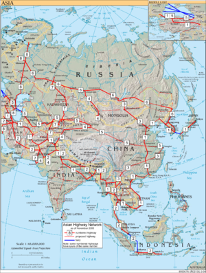
Map of the highways

Asian Highway 2 sign near Ratchaburi, Thailand

A section of Malaysia's North-South Expressway in Penang. Note the Asian Highway 2 signage.

Asian Highway Route Sign. This sign is used on the AH 18.
The Asian Highway Network (AH), also known as the Great Asian Highway, is a cooperative project among countries in Asia and Europe and the United Nations Economic and Social Commission for Asia and the Pacific (ESCAP), to improve the highway systems in Asia. It is one of the three pillars of the Asian Land Transport Infrastructure Development (ALTID) project, endorsed by the ESCAP commission at its 48th session in 1992, comprising Asian Highway, Trans-Asian Railway (TAR) and facilitation of land transport projects.
Agreements have been signed by 32 countries to allow the highway to cross the continent and also reach to Europe. Some of the countries taking part in the highway project are India (Look-East connectivity projects), Sri Lanka, Pakistan, China, Iran, Japan, South Korea and Bangladesh.[1] Most of the funding comes from the larger, more advanced Asian nations like Japan, India, Taiwan, South Korea and China as well as international agencies such as the Asian Development Bank.
The project aims to make maximum use of the continent's existing highways to avoid the construction of newer ones, except in cases where missing routes necessitate their construction. Project Monitor, an Asian infrastructure news website, has commented that "early beneficiaries of the Asian Highway project are the planners within the national land transport department of the participating countries [since] it assists them in planning the most cost-effective and efficient routes to promote domestic and international trade. Non-coastal areas, which are often negligible, are the other beneficiaries."[1]
However, in the mid-2000s some transportation experts were sceptical about the viability of the project given the economic and political climate in both South and Southeast Asia.[1]
The Asian Highway Network is going to take over 2 projects, one is the AH 45 and the other is the new AH 45A. AH 45A is the new highway all over Asia from Tonghua to Sana'a.[citation needed]
Contents
1 History
2 Implications
3 Regional perceptions of the project
4 Routes
5 Numbering and signage
6 First car crossing
7 Route log
7.1 AH1 to AH8: Continent-Wide Routes
7.2 AH10 to AH29: Southeast Asia Routes
7.2.1 AH100 to AH299: ASEAN Southeast Asia Routes
7.3 AH30 to AH39: East Asia and Northeast Asia Routes
7.4 AH40 to AH59: South Asian Routes
7.5 AH60 to AH89: North Asia, Central Asia and Southwest Asia Routes
8 Distance by country
9 See also
10 References
11 External links
History
The AH project was initiated by the United Nations in 1959 with the aim of promoting the development of international road transport in the region. During the first phase of the project (1960–1970) considerable progress was achieved, however, progress slowed down when financial assistance was suspended in 1975.
ESCAP has conducted several projects in cooperation with AH member countries step by step after the endorsement of ALTID in 1992.
The Intergovernmental Agreement on the Asian Highway Network (IGA) was adopted on November 18, 2003, by the Intergovernmental Meeting; the IGA includes Annex I, which identifies 55 AH routes among 32 member countries totalling approximately 140,000 km (87,500 miles), and Annex II "Classification and Design Standards". During the 60th session of the ESCAP Commission at Shanghai, China, in April 2004, the IGA treaty was signed by 23 countries. By 2013, 29 countries had ratified the agreement.[2]
Implications
The advanced highway network would provide for greater trade and social interactions between Asian countries, including personal contacts, project capitalizations, connections of major container terminals with transportation points, and promotion of tourism via the new roadways.[1]
Regional perceptions of the project
According to Om Prakash, "It's an excellent step taken by ESCAP to gather all the Asian countries under one crown but the problem with this project is political disputes between some countries, notably Pakistan and Myanmar, which is delaying the project".[1]
Routes
Route AH1 is proposed to extend from Tokyo to the border with Bulgaria west of Istanbul and Edirne, passing through both Koreas, China and other countries in Southeast, Central and South Asia. The corridor is expected to improve trade links between East Asian countries, India and Russia. To complete the route, existing roads will be upgraded and new roads constructed to link the network. US$25 billion has been spent or committed as of 2007, with additional US$18 billion needed for upgrades and improvements to 26,000 km of highway.[3]
Numbering and signage
The project new highway route numbers begin with "AH", standing for "Asian Highway", followed by one, two or three digits.[4] Single-digit route numbers from 1 to 9 are assigned to major Asian Highway routes which cross more than one subregion.[4] Two- and three-digit route numbers are assigned to indicate the routes within subregions, including those connecting to neighbouring subregions, and self-contained highway routes within the participating countries.[4] Route numbers are printed in the Latin script and Hindu-Arabic numerals and may simply be added to existing signage, like the E-road network.[4]
The actual design of the signs has not been standardized, only that the letters and digits are in white or black, but the color, shape and size of the sign being completely flexible. Most examples feature a blue rectangular shield with a white inscription (similar to German Autobahn signage) with further examples of white on green and black on white rectangular shields.[1][4][5]
First car crossing
What is believed to be the first car crossing of the full extent (East to West) of the new Asian Highway was achieved by Britons Richard Meredith and Phil Colley in 2007 driving an Aston Martin.
Following the AH1 and the AH5 from Tokyo (the Highway grid's furthest point East) to Istanbul (furthest West), they drove a total of 12089 km (7512 miles) before joining the European motorway network for another 3259 km (2025 miles) to London.
Including ferry trips and customs clearance delays, the journey took 49 days and crossed 18 countries.
The completed route was verified by Aston Martin[6] and the UN's Asian Commission (UNESCAP) in Bangkok, whose director of transport and tourism Barry Cable confirmed "I can warrant that, to my best knowledge, this was the first car to undertake this journey".[7][8]
Eurowatch in London provided independent corroboration by tracking the car's location from satellite position reports and plotting the vehicle's location throughout the journey.[9][10]
Meredith, a travel author and veteran of distance-driving events, agreed to make the attempt after attending the Asian Highway Treaty's "coming into force" ceremony in Bangkok on July 4, 2005.
He was lent an Aston Martin V8 Vantage which had previously been the personal transport of the company's chief executive Dr Ulrich Bez and recruited Phil Colley, a linguist and travel expert from Kennington, South London, to be his co-driver. The car was shipped out to Tokyo by the company and they set off on June 25.[11]
Although the trip was facilitated by UNESCAP through its member nations, there were still extensive problems[12] including enforced detours and interminable customs clearance delays in China, pot-holed roads in Kazakhstan and leaded-only fuel in Uzbekistan. In Tbilisi, Georgia, the journey car crashed after being left on a hillside with its handbrake unsecured.
When the record-setting car returned[13][14] a welcome-home reception was staged by Aston Martin at the Park Lane Hotel in London and Meredith later received a civic award from his home town of Milton Keynes.[15][16][17]
The car was sold at auction in December 2007 by Bonhams[18][19] and the proceeds donated to UNICEF, the United Nations Children's Fund. In March 2008 a total collection of €83,000 was presented to UNICEF China for a campaign to reduce child deaths on the roads of Beijing.[20]
Route log
AH1 to AH8: Continent-Wide Routes
| Route No. | Distance | Start | End |
|---|---|---|---|
AH1 | 20,557 km (12,848 miles) | Tokyo, Japan | Kapıkule, Turkey (Bulgaria-Turkey border) |
AH2 | 13,177 km (8326 miles) | Denpasar, Bali, Indonesia | Khosravi, Iran |
AH3 | 7,331 km (4582 miles) | Ulan-Ude, Russia Shanghai, China | Tanggu, China Chiang Rai, Thailand and Kyaing Tong, Myanmar |
AH4 | 6,024 km (3765 miles) | Novosibirsk, Russia | Karachi, Pakistan |
AH5 | 10,380 km (6488 miles) | Shanghai, China | Kapıkule, Turkey (Bulgaria-Turkey border) |
AH6 | 10,475 km (6547 miles) | Busan, South Korea | Krasnoye, Russia (Belarus-Russia border) |
AH7 | 5,868 km (3667.5 miles) | Yekaterinburg, Russia | Karachi, Pakistan |
AH8 | 4,718 km (2949 miles) | Torfyanovka, Russia (Russia-Finland border) | Bandar-e Emam Khomeyni, Iran |
AH10 to AH29: Southeast Asia Routes
| Route No. | Distance | Start | End | Notes |
|---|---|---|---|---|
AH11 | 1,588 km (992.5 miles) | Vientiane, Laos | Sihanoukville, Cambodia | |
AH12 | 1,195 km (747 miles) | Nateuy, Laos | Hin Kong, Thailand | |
AH13 | 730 km (456 miles) | Oudomxai, Laos | Nakhon Sawan, Thailand | |
AH14 | 2,077 km (1298 miles) | Hai Phong, Vietnam | Mandalay, Myanmar | |
AH15 | 566 km (354 miles) | Vinh, Vietnam | Udon Thani, Thailand | |
AH16 | 1,032 km (645 miles) | Đông Hà, Vietnam | Tak, Thailand | |
AH17 | 980 km (608 miles) | Đà Nẵng, Vietnam | Vũng Tàu, Vietnam | |
AH18 | 1,042 km (651 miles) | Hat Yai, Thailand | Johor Bahru Causeway, Johor Bahru, Malaysia | |
AH19 | 459 km (287 miles) | Nakhon Ratchasima, Thailand | Bangkok, Thailand | |
AH25 | 2,549 km (1593 miles) | Banda Aceh, Indonesia | Merak, Indonesia | Also known as the Trans-Sumatran Highway |
AH26 | 3,517 km (2198 miles) | Laoag, Philippines | Zamboanga, Philippines | Also known as the Pan-Philippine Highway. Most of the sections of the highway are also co-signed as |
AH100 to AH299: ASEAN Southeast Asia Routes
These routes were set up by the Association of Southeast Asian Nations as part of an extension to the Asian Highway Network, known as the ASEAN Highway Network.[21][22]
| Route No. | Distance | Start | End | Notes |
|---|---|---|---|---|
AH111 | Loilem, Myanmar | Thibaw, Myanmar | [23] | |
AH112 | Thaton, Myanmar | Kawthaung, Myanmar | [23] | |
AH121 | Mukdahan, Thailand | Sa Kaeo, Thailand | ||
AH123 | Dawei. Myanmar | Pak Tho on AH2 in Thailand | [23][24] | |
AH140 | Butterworth Malaysia | Pasir Puteh, Malaysia | ||
AH141 | Port Klang Malaysia | Kuantan, Malaysia | ||
AH142 | Yong Peng, Malaysia | Gambang, Malaysia | ||
AH143 | Sengkang, Singapore | Senai, Malaysia | ||
AH150 | Semantan, Sarawak | Tawau, Sabah | Also known as the Pan-Borneo Highway |
AH30 to AH39: East Asia and Northeast Asia Routes
| Route No. | Distance | Start | End |
|---|---|---|---|
AH30 | 2,739 km (1712 miles) | Ussuriysk, Russia | Chita, Russia |
AH31 | 1,595 km (997 miles) | Belogorsk, Russia | Dalian, China |
AH32 | 3,748 km (2342.5 miles) | Sonbong, North Korea | Khovd, Mongolia |
AH33 | 575 km (359 miles) | Harbin, China | Tongjiang, China |
AH34 | 1,033 km (646 miles) | Lianyungang, China | Xi'an, China |
AH40 to AH59: South Asian Routes
| Route No. | Distance | Start | End |
|---|---|---|---|
AH41 | 948 km (592.5 miles) | Teknaf, Bangladesh | Mongla, Bangladesh |
AH42 | 3,754 km (2346 miles) | Lanzhou, China | Barhi, India |
AH43 | 3,024 km (1892 miles) | Agra, India | Matara, Sri Lanka |
AH44 | 107 km (67 miles) | Dambulla, Sri Lanka | Trincomalee, Sri Lanka |
AH45 | 2,030 km (1269 miles) | Kolkata, India | Bengaluru, India |
AH46 | 1,967 km (1,222 miles) | Hazira, India | Howrah,(Kolkata) |
AH47 | 2,057 km (1286 miles) | Gwalior, India | Bengaluru, India |
AH48 | 90 km (56 miles) | Phuentsholing, Bhutan | Changrabandha, India Bangladesh-India border |
AH51 | 862 km (539 miles) | Peshawar, Pakistan | Quetta, Pakistan |
AH60 to AH89: North Asia, Central Asia and Southwest Asia Routes
| Route No. | Distance | Start | End |
|---|---|---|---|
AH60 | 2,151 km (1344 miles) | Omsk, Russia (on AH6) | Burubaital, Kazakhstan (on AH7) |
AH61 | 4,158 km (2599 miles) | Kashgar, China (on AH4/AH65) | border between Russia and Ukraine |
AH62 | 2,722 km (1701 miles) | Petropavl, Kazakhstan (on AH6/AH64) | Mazari Sharif, Afghanistan (on AH76) |
AH63 | 2,434 km (1521 miles) | Samara, Russia (on AH6) | Guzar, Uzbekistan (on AH62) |
AH64 | 1,666 km (1041 miles) | Petropavl, Kazakhstan (on AH6/AH62) | Barnaul, Russia (on AH4) |
AH65 | 1,250 km (781 miles) | Kashgar, China (on AH4/AH61) | Termez, Uzbekistan (on AH62) |
AH66 | 995 km (622 miles) | border between China and Tajikistan | Termez, Uzbekistan (on AH62) |
AH67 | 2,288 km (1430 miles) | Kuitun, China (on AH5) | Zhezkazgan, Kazakhstan (on AH62) |
AH68 | 278 km (174 miles) | Jinghe, China (on AH5) | Ucharal, Kazakhstan (on AH60) |
AH70 | 4,832 km (3020 miles) | border between Ukraine and Russia | Bandar Abbas, Iran |
AH71 | 426 km (266 miles) | Dilaram, Afghanistan (on AH1) | Dashtak, Iran (on AH75) |
AH72 | 1,147 km (717 miles) | Tehran, Iran (on AH1/AH2/AH8) | Bushehr, Iran |
AH75 | 1,871 km (1169 miles) | Tejen, Turkmenistan (on AH5) | Chabahar, Iran |
AH76 | 986 km (616 miles) | Polekhumri, Afghanistan (on AH7) | Herat, Afghanistan (on AH1/AH77) |
AH77 | 1,298 km (811 miles) | Djbulsarcj, Afghanistan (on AH7) | Mary, Turkmenistan (on AH5) |
AH78 | 1,076 km (672.5 miles) | Ashgabat, Turkmenistan (on AH5) | Kerman, Iran (on AH2) |
AH81 | 1,143 km (714 miles) | Larsi, Georgia | Aktau, Kazakhstan (on AH70) |
AH82 | 1,261 km (788 miles) | border between Russia and Georgia | Ivughli, Iran (on AH1) |
AH83 | 172 km (107.5 miles) | Kazakh, Azerbaijan (on AH5) | Yerevan, Armenia (on AH81/AH82) |
AH84 | 1,188 km (742.5 miles) | Doğubeyazıt, Turkey (on AH1) | İçel, Turkey |
AH85 | 338 km (211 miles) | Refahiye, Turkey (on AH1) | Merzifon, Turkey (on AH5) |
AH86 | 247 km (154 miles) | Askale, Turkey (on AH1) | Trabzon, Turkey (on AH5) |
AH87 | 606 km (378.75 miles) | Ankara, Turkey (on AH1) | İzmir, Turkey |
Distance by country
The planned network runs a total of 140,479 kilometres (87,290 mi).
| Country | Distance in km | Distance in Miles |
|---|---|---|
| 4,247 | 2,639 | |
| 958 | 595 | |
| 1,442 | 896 | |
| 1,804 | 1,121 | |
| 1 | 0.621 | |
| 1,339 | 832 | |
| 25,579 | 15,894 | |
| 1,320 | 820 | |
| 1,154 | 717 | |
| 91 | 57 | |
| 27,432 | 17,104 | |
| 3,989 | 2,479 | |
| 11,152 | 6,930 | |
| 1,200 | 746 | |
| 13,189 | 8,195 | |
| 1,695 | 1,053 | |
| 2,297 | 1,427 | |
| 4,006 | 2,489 | |
| 4,286 | 2,663 | |
| 3,003 | 1,866 | |
| 1,321 | 821 | |
| 5,377 | 3,341 | |
| 3,517 | 2,185 | |
| 907 | 564 | |
| 16,869 | 10,482 | |
| 19 | 12 | |
| 650 | 404 | |
| 1,925 | 1,196 | |
| 5,112 | 3,176 | |
| 5,254 | 3,265 | |
| 2,204 | 1,370 | |
| 2,966 | 1,843 | |
| 2,678 | 1,664 |
See also
- International E-road network
- Arab Mashreq International Road Network
- Trans-Asian Railway
- Japan–Korea Undersea Tunnel
- One Belt, One Road
- Eurasian Land Bridge
- Hippie trail
References
^ abcdef Kamat, Rahul The Great Asian Highway Archived 2010-01-17 at the Wayback Machine., Project Monitor website, 31 January 2005. Retrieved 2009-05-05
^ "Archived copy". Archived from the original on 2014-05-28. Retrieved 2013-05-15.CS1 maint: Archived copy as title (link) .mw-parser-output cite.citationfont-style:inherit.mw-parser-output qquotes:"""""""'""'".mw-parser-output code.cs1-codecolor:inherit;background:inherit;border:inherit;padding:inherit.mw-parser-output .cs1-lock-free abackground:url("//upload.wikimedia.org/wikipedia/commons/thumb/6/65/Lock-green.svg/9px-Lock-green.svg.png")no-repeat;background-position:right .1em center.mw-parser-output .cs1-lock-limited a,.mw-parser-output .cs1-lock-registration abackground:url("//upload.wikimedia.org/wikipedia/commons/thumb/d/d6/Lock-gray-alt-2.svg/9px-Lock-gray-alt-2.svg.png")no-repeat;background-position:right .1em center.mw-parser-output .cs1-lock-subscription abackground:url("//upload.wikimedia.org/wikipedia/commons/thumb/a/aa/Lock-red-alt-2.svg/9px-Lock-red-alt-2.svg.png")no-repeat;background-position:right .1em center.mw-parser-output .cs1-subscription,.mw-parser-output .cs1-registrationcolor:#555.mw-parser-output .cs1-subscription span,.mw-parser-output .cs1-registration spanborder-bottom:1px dotted;cursor:help.mw-parser-output .cs1-hidden-errordisplay:none;font-size:100%.mw-parser-output .cs1-visible-errorfont-size:100%.mw-parser-output .cs1-subscription,.mw-parser-output .cs1-registration,.mw-parser-output .cs1-formatfont-size:95%.mw-parser-output .cs1-kern-left,.mw-parser-output .cs1-kern-wl-leftpadding-left:0.2em.mw-parser-output .cs1-kern-right,.mw-parser-output .cs1-kern-wl-rightpadding-right:0.2em.
^ "Priority Investment Needs for the Development for the Asian Highway Network" Archived July 20, 2007, at the Wayback Machine., accessed July 14, 2007
^ abcde Newswire Archived January 12, 2010, at the Wayback Machine., Tourism Commission of the International Geographical Union website. Retrieved 2009-05-05;
^ McCartan, Brian Roadblocks on the Great Asian Highway, Asia Times website, 23 January 2008. Retrieved 2009-05-05;
^ Letter 2007-07-09 Janette Green, Director Brand Communications, Aston Martin, Gaydon CV35 0DB, England
^ Letter 2007-18-10 Barry Cable, Director Transport & Tourism Division, United Nations ESCAP (Economic & Social Commission for Asia & the Pacific), Bangkok 10200, Thailand.
^ (2008) Driven Together Published by Mercury Books on behalf of Word Go Ltd. Page vi (
ISBN 9780954143244)
^ Tracking and map log Letter and data 2007-28-09 Dr Sebastian Archer, Solutions ARchitect, EurowatchCEntral Ltd, London EC4Y 0HB.
^ Driven Together - Outside Back Cover.
^ Aston Martin on the Asia-Pacific Highway AutoRacing.com, 2007-09-07. Retrieved 2010-01-01
^ Driven Together - Various
^ Reuters Aston Martin drivers set Asian Highway record NZ Herald, 2007-15-08. Retrieved 2010-01-01
^ Wilkinson, Stephen Hammer Down on Asia's Interstate Highways Concierge.com, 2007-23-08. Retrieved 2010-01-01
^ British Pair Drive Aston Martin into the Record Books Aston Martin, 2007-14-08. Retrieved 2010-01-01
^ Milton Keynes Citizen 2007-13-09 "Aston adventurer safely home" Page 26
^ MK News 2007-12-09 "Records shattered on drive home from Japan" Page 22
^ Record-Breaking Aston Martin to be Sold Archived September 28, 2011, at the Wayback Machine. Bonhams, 2007-03-12. Retrieved 2010-01-01
^ 103-year-old Rolls Royce sells for a record £3.5m at auction Mail Online, 2007-03-12. Retrieved 2010-01-01
^ Milton Keynes Citizen 2008-11-03 "Aston adventure" Page 2
^ ASEAN logistics network map. Nihon Bōeki Shinkōkai. (2nd ed.). Tokyo: JETRO. 2009. ISBN 4822410684. OCLC 434492237.
^ Master plan on ASEAN connectivity (PDF). ASEAN. Public Outreach and Civil Society Division. [Jakarta, Indonesia]: [ASEAN Secretariat, Public Outreach and Civil Society Division]. December 2010. p. 12. ISBN 9786028411622. OCLC 775662227. Archived from the original (PDF) on 2017-07-06. Retrieved 2018-01-12.
^ abc "Status of the Asian Highway in Member Countries | United Nations ESCAP". www.unescap.org. Retrieved 2018-01-12.
^ Master plan on ASEAN connectivity, 2025 (PDF). Jakarta. ISBN 9786026392022. OCLC 970396295. Retrieved 2018-01-12.
External links
- The project homepage
- Intergovernmental Agreement on the Asian Highway Network
Asia signs up to 'new Silk Road' BBC News report (April 26, 2004)- UNESCAP press release announcing treaty
- 2003 Asian Highway Handbook
- Pakistan's Gwadar to Afghanistan, China road declared Asian Highway
- Driven Together, Historic first crossing of Asia's new Highway to the West
- Asian Highway Network Details
Asian Highway Network | ||
|---|---|---|
| Across the whole continent |
|  |
| Southeast Asia |
| |
| East Asia, Northeast Asia and Southeast Asia |
| |
| South Asia |
| |
| North Asia, Central Asia and Southwest Asia |
| |


