Victoria, Seychelles
Victoria | |
|---|---|
 Victoria | |
 Location of Victoria on Mahé Island | |
 Victoria Location in Seychelles | |
| Coordinates: 4°37′S 55°27′E / 4.617°S 55.450°E / -4.617; 55.450 | |
| Country | Seychelles |
| Island | Mahé |
| Government | |
| • Mayor | David Andre |
| Area | |
| • Total | 20.1 km2 (7.8 sq mi) |
| Population (2010)[1] | |
| • Total | 26,450 |
Victoria (French pronunciation: [viktɔʁja]) is the capital and largest city of Seychelles, situated on the north-eastern side of Mahé island, the archipelago's main island. The city was first established as the seat of the British colonial government. In 2010, the population of Greater Victoria (including the suburbs) was 26,450 out of the country's total population of 90,945.[2]
The principal exports of Victoria are vanilla, coconuts, coconut oil, fish and guano.[3]
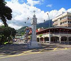
Victoria Clocktower
Attractions in the city include a clocktower modelled on that of Vauxhall Clock Tower in London, England,[3][4] the Courthouse, the Victoria Botanical Gardens, the Victoria National Museum of History, the Victoria Natural History Museum and the Sir Selwyn Selwyn-Clarke Market.[3] Victoria Market and the brightly coloured fish and fruit markets are the local hotspot for the Seychellois people. Also nearby is the gallery of local artist Georges Camille.
The city is home to the national stadium, the International School Seychelles and a polytechnic.
Victoria is served by Seychelles International Airport, completed in 1971.[3] The inner harbour lies immediately east of the town, where tuna fishing and canning forms a major local industry.[3] One of the largest bridges in Victoria was destroyed by tsunami waves from the 2004 Indian Ocean earthquake.[4]
Contents
1 History
2 District
3 Twin towns and sister cities
4 Climate
5 See also
6 References
7 External links
History
The area that would become Victoria was originally settled in 1778 by French colonists after they claimed the island in 1756, but it was not until after the Treaty of Paris of 1814 was signed that the British formally established Victoria and gave it its modern name.[5][6]
District
Victoria proper is composed of parts of three Districts of Seychelles:
English River (La Rivière Anglaise) (the innermost part)- Saint Louis
- Mont Fleuri
Greater Victoria encompasses these three, and five more of the 25 Districts of Seychelles as follows:
- Mont Buxton
- Bel Air
- Roche Caiman
- Les Mamelles
- Plaisance
Twin towns and sister cities
Victoria is twinned with:
| Country | City |
|---|---|
Haikou |
Climate
Victoria features a tropical rainforest climate (Köppen climate classification Af) with high temperatures throughout the course of the year. The capital does have noticeably wetter and drier periods during the year, with June and July being its driest months and December through February being the city's wettest months. However, since in no month does the average monthly precipitation falls below 60 mm in Victoria, the city does not have a true dry season month. This lack of a true dry season month is a primary reason why the climate falls under the tropical rainforest climate category. The capital averages about 2,000 mm of precipitation annually. Although being very rainy, skies are usually clear to partly clear and completely cloudy days remain scarce throughout the year even during the rainiest months.
| Climate data for Victoria (Seychelles International Airport) 1972–2011 | |||||||||||||
|---|---|---|---|---|---|---|---|---|---|---|---|---|---|
| Month | Jan | Feb | Mar | Apr | May | Jun | Jul | Aug | Sep | Oct | Nov | Dec | Year |
| Record high °C (°F) | 33.3 (91.9) | 33.4 (92.1) | 33.5 (92.3) | 34.1 (93.4) | 33.5 (92.3) | 32.6 (90.7) | 31.1 (88.0) | 31.4 (88.5) | 31.6 (88.9) | 32.4 (90.3) | 34.4 (93.9) | 33.4 (92.1) | 34.4 (93.9) |
| Average high °C (°F) | 29.9 (85.8) | 30.5 (86.9) | 31.1 (88.0) | 31.5 (88.7) | 30.7 (87.3) | 29.2 (84.6) | 28.4 (83.1) | 28.6 (83.5) | 29.2 (84.6) | 29.9 (85.8) | 30.2 (86.4) | 30.2 (86.4) | 30.0 (86.0) |
| Daily mean °C (°F) | 26.9 (80.4) | 27.5 (81.5) | 27.9 (82.2) | 28.1 (82.6) | 27.9 (82.2) | 26.8 (80.2) | 26.0 (78.8) | 26.1 (79.0) | 26.5 (79.7) | 26.9 (80.4) | 27.0 (80.6) | 27.0 (80.6) | 27.1 (80.8) |
| Average low °C (°F) | 24.3 (75.7) | 24.9 (76.8) | 25.1 (77.2) | 25.3 (77.5) | 25.6 (78.1) | 24.8 (76.6) | 24.1 (75.4) | 24.1 (75.4) | 24.4 (75.9) | 24.6 (76.3) | 24.3 (75.7) | 24.2 (75.6) | 24.6 (76.3) |
| Record low °C (°F) | 24.1 (75.4) | 21.1 (70.0) | 22.1 (71.8) | 22.3 (72.1) | 21.6 (70.9) | 20.9 (69.6) | 20.4 (68.7) | 19.6 (67.3) | 20.2 (68.4) | 20.5 (68.9) | 21.5 (70.7) | 20.0 (68.0) | 19.6 (67.3) |
| Average rainfall mm (inches) | 401.3 (15.80) | 270.2 (10.64) | 195.5 (7.70) | 188.1 (7.41) | 146.0 (5.75) | 102.9 (4.05) | 80.3 (3.16) | 114.2 (4.50) | 150.0 (5.91) | 192.8 (7.59) | 205.0 (8.07) | 303.2 (11.94) | 2,349.5 (92.50) |
| Average relative humidity (%) | 83 | 80 | 80 | 80 | 79 | 79 | 80 | 79 | 79 | 79 | 80 | 82 | 80 |
| Mean monthly sunshine hours | 155.0 | 175.2 | 213.9 | 231.0 | 254.2 | 225.0 | 232.5 | 232.5 | 219.0 | 226.3 | 204.0 | 176.7 | 2,545.3 |
| Mean daily sunshine hours | 5.0 | 6.2 | 6.9 | 7.7 | 8.2 | 7.5 | 7.5 | 7.5 | 7.3 | 7.3 | 6.8 | 5.7 | 6.97 |
| Source: Seychelles National Meteorological Services[7][8][9][10][11][12][13][14][15][16][17][18] | |||||||||||||
See also
- Port of Victoria (Seychelles)
- Romainville Island, Seychelles
References
^ ab "SEYCHELLES". citypopulation.de. City Population. Retrieved 15 June 2015..mw-parser-output cite.citationfont-style:inherit.mw-parser-output .citation qquotes:"""""""'""'".mw-parser-output .citation .cs1-lock-free abackground:url("//upload.wikimedia.org/wikipedia/commons/thumb/6/65/Lock-green.svg/9px-Lock-green.svg.png")no-repeat;background-position:right .1em center.mw-parser-output .citation .cs1-lock-limited a,.mw-parser-output .citation .cs1-lock-registration abackground:url("//upload.wikimedia.org/wikipedia/commons/thumb/d/d6/Lock-gray-alt-2.svg/9px-Lock-gray-alt-2.svg.png")no-repeat;background-position:right .1em center.mw-parser-output .citation .cs1-lock-subscription abackground:url("//upload.wikimedia.org/wikipedia/commons/thumb/a/aa/Lock-red-alt-2.svg/9px-Lock-red-alt-2.svg.png")no-repeat;background-position:right .1em center.mw-parser-output .cs1-subscription,.mw-parser-output .cs1-registrationcolor:#555.mw-parser-output .cs1-subscription span,.mw-parser-output .cs1-registration spanborder-bottom:1px dotted;cursor:help.mw-parser-output .cs1-ws-icon abackground:url("//upload.wikimedia.org/wikipedia/commons/thumb/4/4c/Wikisource-logo.svg/12px-Wikisource-logo.svg.png")no-repeat;background-position:right .1em center.mw-parser-output code.cs1-codecolor:inherit;background:inherit;border:inherit;padding:inherit.mw-parser-output .cs1-hidden-errordisplay:none;font-size:100%.mw-parser-output .cs1-visible-errorfont-size:100%.mw-parser-output .cs1-maintdisplay:none;color:#33aa33;margin-left:0.3em.mw-parser-output .cs1-subscription,.mw-parser-output .cs1-registration,.mw-parser-output .cs1-formatfont-size:95%.mw-parser-output .cs1-kern-left,.mw-parser-output .cs1-kern-wl-leftpadding-left:0.2em.mw-parser-output .cs1-kern-right,.mw-parser-output .cs1-kern-wl-rightpadding-right:0.2em
^ Encyclopædia Britannica, Inc. (1 March 2014). Britannica Book of the Year 2014. Encyclopædia Britannica, Inc. p. 716. ISBN 978-1-62513-171-3.
^ abcde Cybriwsky, Roman A. (2013). Capital Cities around the World. ABC-CLIO. p. 321. ISBN 9781610692489.
^ ab Encyclopedia of Africa. Oxford University Press. 2010. p. 530. ISBN 9780195337709.
^ "History". seychelles.travel. Seychelles Tourism Board. Retrieved 16 June 2015.
^ "History of the Seychelles". stgt.com. Archived from the original on 1 May 2017. Retrieved 16 June 2015.
^
"Climatic Averages for January" (PDF). Seychelles Climate Guide. Seychelles National Meteorological Services. Retrieved 20 July 2016.
^
"Climatic Averages for February" (PDF). Seychelles Climate Guide. Seychelles National Meteorological Services. Retrieved 20 July 2016.
^
"Climatic Averages for March" (PDF). Seychelles Climate Guide. Seychelles National Meteorological Services. Retrieved 20 July 2016.
^
"Climatic Averages for April" (PDF). Seychelles Climate Guide. Seychelles National Meteorological Services. Retrieved 20 July 2016.
^
"Climatic Averages for May" (PDF). Seychelles Climate Guide. Seychelles National Meteorological Services. Retrieved 20 July 2016.
^
"Climatic Averages for June" (PDF). Seychelles Climate Guide. Seychelles National Meteorological Services. Retrieved 20 July 2016.
^
"Climatic Averages for July" (PDF). Seychelles Climate Guide. Seychelles National Meteorological Services. Retrieved 20 July 2016.
^
"Climatic Averages for August" (PDF). Seychelles Climate Guide. Seychelles National Meteorological Services. Retrieved 20 July 2016.
^
"Climatic Averages for September" (PDF). Seychelles Climate Guide. Seychelles National Meteorological Services. Retrieved 20 July 2016.
^
"Climatic Averages for October" (PDF). Seychelles Climate Guide. Seychelles National Meteorological Services. Retrieved 20 July 2016.
^
"Climatic Averages for November" (PDF). Seychelles Climate Guide. Seychelles National Meteorological Services. Retrieved 20 July 2016.
^
"Climatic Averages for December" (PDF). Seychelles Climate Guide. Seychelles National Meteorological Services. Retrieved 20 July 2016.
External links
| Wikimedia Commons has media related to Victoria (Seychelles). |
 Victoria, Seychelles travel guide from Wikivoyage
Seychelles articles | |||
|---|---|---|---|
| History |
|  | |
| Geography |
| ||
| Politics |
| ||
| Economy |
| ||
| Society |
| ||
| |||
Coordinates: 4°37′00″S 55°27′00″E / 4.6167°S 55.4500°E / -4.6167; 55.4500
Authority control |
|
|---|
