National Register of Historic Places listings in Scott County, Virginia
[dummy-text]
National Register of Historic Places listings in Scott County, Virginia
Jump to navigation
Jump to search
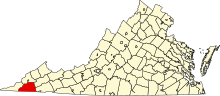
Location of Scott County in Virginia
This is a list of the National Register of Historic Places listings in Scott County, Virginia.
This is intended to be a complete list of the properties and districts on the National Register of Historic Places in Scott County, Virginia, United States. The locations of National Register properties and districts for which the latitude and longitude coordinates are included below, may be seen in a Google map.[1]
There are 10 properties and districts listed on the National Register in the county.
This National Park Service list is complete through NPS recent listings posted November 2, 2018.[2]
Current listings[edit]
| [3] | Name on the Register[4] | Image | Date listed[5] | Location | City or town | Description |
|---|---|---|---|---|---|---|
1 | Bush Mill |  | September 5, 2008 (#08000831) | 1162 Bush Mill Rd. 36°45′21″N 82°26′07″W / 36.755833°N 82.435139°W / 36.755833; -82.435139 (Bush Mill) | Nickelsville | |
2 | A. P. and Sara Carter House | 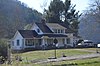 | June 12, 1985 (#85001410) | A.P. Carter Highway 36°40′08″N 82°24′37″W / 36.668889°N 82.410278°W / 36.668889; -82.410278 (A. P. and Sara Carter House) | Maces Spring | |
3 | A. P. Carter Homeplace |  | July 30, 1976 (#76002118) | Southeast of Maces Spring near the junction of the A.P. Carter Highway and Lunsford Mill Rd. 36°40′07″N 82°24′44″W / 36.668611°N 82.412361°W / 36.668611; -82.412361 (A. P. Carter Homeplace) | Maces Spring | |
4 | A. P. Carter Store |  | June 14, 1985 (#85001411) | A.P. Carter Highway 36°40′06″N 82°24′47″W / 36.668333°N 82.412917°W / 36.668333; -82.412917 (A. P. Carter Store) | Maces Spring | |
5 | Maybelle and Ezra Carter House |  | June 12, 1985 (#85001412) | A.P. Carter Highway 36°40′27″N 82°24′09″W / 36.674167°N 82.402500°W / 36.674167; -82.402500 (Maybelle and Ezra Carter House) | Maces Spring | |
6 | Flanary Archeological Site (44SC13) |  | July 7, 1983 (#83003315) | Across the Clinch River from Dungannon, directly south of the bridge[6] 36°49′51″N 82°27′35″W / 36.830833°N 82.459722°W / 36.830833; -82.459722 (Flanary Archeological Site (44SC13)) | Dungannon | |
7 | Fulkerson-Hilton House |  | September 14, 2002 (#02001006) | Dowell Gap Rd. at the North Fork of the Holston River[7] 36°39′02″N 82°26′35″W / 36.650417°N 82.443056°W / 36.650417; -82.443056 (Fulkerson-Hilton House) | Hiltons | |
8 | Gate City Historic District |  | September 10, 2010 (#10000735) | Five blocks on E. and W. Jackson St. 36°38′18″N 82°34′48″W / 36.638333°N 82.580000°W / 36.638333; -82.580000 (Gate City Historic District) | Gate City | |
9 | Killgore Fort House | 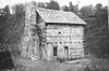 | May 19, 1972 (#72001415) | Southwest of Nickelsville off State Route 71 36°44′05″N 82°26′03″W / 36.734861°N 82.434167°W / 36.734861; -82.434167 (Killgore Fort House) | Nickelsville | |
10 | Mt. Vernon Methodist Church |  | June 12, 1985 (#85001413) | A.P. Carter Highway 36°40′36″N 82°23′16″W / 36.676667°N 82.387639°W / 36.676667; -82.387639 (Mt. Vernon Methodist Church) | Maces Spring |
See also[edit]
| Wikimedia Commons has media related to National Register of Historic Places in Scott County, Virginia. |
- List of National Historic Landmarks in Virginia
- National Register of Historic Places listings in Virginia
References[edit]
^ The latitude and longitude information provided in this table was derived originally from the National Register Information System, which has been found to be fairly accurate for about 99% of listings. For about 1% of NRIS original coordinates, experience has shown that one or both coordinates are typos or otherwise extremely far off; some corrections may have been made. A more subtle problem causes many locations to be off by up to 150 yards, depending on location in the country: most NRIS coordinates were derived from tracing out latitude and longitudes from USGS topographical quadrant maps created under the North American Datum of 1927, which differs from the current, highly accurate WGS84 GPS system used by most on-line maps. Chicago is about right, but NRIS longitudes in Washington are higher by about 4.5 seconds, and are lower by about 2.0 seconds in Maine. Latitudes differ by about 1.0 second in Florida. Some locations in this table may have been corrected to current GPS standards.
^ "National Register of Historic Places: Weekly List Actions". National Park Service, United States Department of the Interior. Retrieved on November 2, 2018.
^ Numbers represent an ordering by significant words. Various colorings, defined here, differentiate National Historic Landmarks and historic districts from other NRHP buildings, structures, sites or objects.
^ National Park Service (2008-04-24). "National Register Information System". National Register of Historic Places. National Park Service..mw-parser-output cite.citationfont-style:inherit.mw-parser-output qquotes:"""""""'""'".mw-parser-output code.cs1-codecolor:inherit;background:inherit;border:inherit;padding:inherit.mw-parser-output .cs1-lock-free abackground:url("//upload.wikimedia.org/wikipedia/commons/thumb/6/65/Lock-green.svg/9px-Lock-green.svg.png")no-repeat;background-position:right .1em center.mw-parser-output .cs1-lock-limited a,.mw-parser-output .cs1-lock-registration abackground:url("//upload.wikimedia.org/wikipedia/commons/thumb/d/d6/Lock-gray-alt-2.svg/9px-Lock-gray-alt-2.svg.png")no-repeat;background-position:right .1em center.mw-parser-output .cs1-lock-subscription abackground:url("//upload.wikimedia.org/wikipedia/commons/thumb/a/aa/Lock-red-alt-2.svg/9px-Lock-red-alt-2.svg.png")no-repeat;background-position:right .1em center.mw-parser-output .cs1-subscription,.mw-parser-output .cs1-registrationcolor:#555.mw-parser-output .cs1-subscription span,.mw-parser-output .cs1-registration spanborder-bottom:1px dotted;cursor:help.mw-parser-output .cs1-hidden-errordisplay:none;font-size:100%.mw-parser-output .cs1-visible-errorfont-size:100%.mw-parser-output .cs1-subscription,.mw-parser-output .cs1-registration,.mw-parser-output .cs1-formatfont-size:95%.mw-parser-output .cs1-kern-left,.mw-parser-output .cs1-kern-wl-leftpadding-left:0.2em.mw-parser-output .cs1-kern-right,.mw-parser-output .cs1-kern-wl-rightpadding-right:0.2em
^ The eight-digit number below each date is the number assigned to each location in the National Register Information System database, which can be viewed by clicking the number.
^ Flannery Archeological Site, Scott County Tourism Bureau, 2016. Accessed 2016-07-23.
^ Hickam, Stanley Lee. National Register of Historic Places Inventory/Nomination: Fulkerson-Hilton House. National Park Service, 2001-05-15, 15.
U.S. National Register of Historic Places in Virginia | ||
|---|---|---|
| Lists by county |
|   |
| Lists by city |
| |
| Other lists |
| |
| ||
Municipalities and communities of Scott County, Virginia, United States | ||
|---|---|---|
County seat: Gate City | ||
| Towns |
|  |
| Unincorporated communities |
| |
Categories:
- National Register of Historic Places in Scott County, Virginia
- Lists of National Register of Historic Places in Virginia by county
(window.RLQ=window.RLQ||).push(function()mw.config.set("wgPageParseReport":"limitreport":"cputime":"0.392","walltime":"0.495","ppvisitednodes":"value":4867,"limit":1000000,"ppgeneratednodes":"value":0,"limit":1500000,"postexpandincludesize":"value":119099,"limit":2097152,"templateargumentsize":"value":6270,"limit":2097152,"expansiondepth":"value":11,"limit":40,"expensivefunctioncount":"value":0,"limit":500,"unstrip-depth":"value":1,"limit":20,"unstrip-size":"value":6319,"limit":5000000,"entityaccesscount":"value":1,"limit":400,"timingprofile":["100.00% 348.564 1 -total"," 34.47% 120.159 1 Template:NRHP_header"," 33.64% 117.244 10 Template:NRHP_row"," 26.84% 93.572 1 Template:NRISref"," 25.39% 88.492 1 Template:Cite_web"," 10.73% 37.403 16 Template:NRHP_color"," 10.50% 36.590 11 Template:Designation/color"," 8.99% 31.323 1 Template:Commons_category"," 7.59% 26.450 10 Template:Coord"," 7.18% 25.026 2 Template:Navbox"],"scribunto":"limitreport-timeusage":"value":"0.109","limit":"10.000","limitreport-memusage":"value":3543228,"limit":52428800,"cachereport":"origin":"mw1273","timestamp":"20181112214951","ttl":1900800,"transientcontent":false);mw.config.set("wgBackendResponseTime":605,"wgHostname":"mw1273"););


