National Register of Historic Places listings in York County, Virginia
[dummy-text]
National Register of Historic Places listings in York County, Virginia
Jump to navigation
Jump to search

Location of York County in Virginia
This is a list of the National Register of Historic Places listings in York County, Virginia.
This is intended to be a complete list of the properties and districts on the National Register of Historic Places in York County, Virginia, United States. The locations of National Register properties and districts for which the latitude and longitude coordinates are included below, may be seen in a Google map.[1]
There are 10 properties and districts listed on the National Register in the county.
This National Park Service list is complete through NPS recent listings posted November 2, 2018.[2]
Current listings[edit]
| [3] | Name on the Register[4] | Image | Date listed[5] | Location | City or town | Description |
|---|---|---|---|---|---|---|
1 | Bruton Parish Poorhouse Archeological Site | September 2, 1982 (#82004610) | State Route 132[6]:1 37°17′46″N 76°41′20″W / 37.296111°N 76.688889°W / 37.296111; -76.688889 (Bruton Parish Poorhouse Archeological Site) | Williamsburg | Sits on a hill about 600 feet (180 m) north-northeast of Queens Creek[6]:2 | |
2 | Bryan Manor | November 14, 1978 (#78003048) | Off Queens Creek Rd.[7] 37°16′10″N 76°39′25″W / 37.269444°N 76.656944°W / 37.269444; -76.656944 (Bryan Manor) | Williamsburg | ||
3 | William Gooch Tomb and York Village Archeological Site | January 18, 1974 (#74002153) | Perimeter Rd. at the U.S. Coast Guard Training Center[8] 37°12′56″N 76°28′42″W / 37.215556°N 76.478333°W / 37.215556; -76.478333 (William Gooch Tomb and York Village Archeological Site) | Yorktown | Boundaries decreased on February 11, 1999 | |
4 | Grace Church | 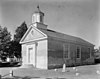 | September 15, 1970 (#70000832) | Church and Main Sts. 37°14′09″N 76°30′28″W / 37.235972°N 76.507639°W / 37.235972; -76.507639 (Grace Church) | Yorktown | |
5 | Kiskiack |  | November 12, 1969 (#69000287) | Northeast of the junction of State Routes 168 and 238 37°14′27″N 76°33′51″W / 37.240833°N 76.564028°W / 37.240833; -76.564028 (Kiskiack) | Lackey | |
6 | Old Custom House |  | June 3, 1999 (#99000682) | Junction of Main and Read Sts. 37°14′05″N 76°30′28″W / 37.234722°N 76.507778°W / 37.234722; -76.507778 (Old Custom House) | Yorktown | |
7 | Porto Bello |  | April 13, 1973 (#73002068) | On Queens Creek, in Camp Peary Military Reservation 37°18′02″N 76°38′40″W / 37.300694°N 76.644444°W / 37.300694; -76.644444 (Porto Bello) | Williamsburg | |
8 | Sessions-Pope-Sheild House | 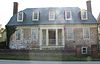 | June 23, 2003 (#03000572) | 600 Main St. 37°14′03″N 76°30′25″W / 37.234167°N 76.506944°W / 37.234167; -76.506944 (Sessions-Pope-Sheild House) | Yorktown | |
9 | Whitaker's Mill Archeological Complex | May 15, 2008 (#08000426) | Along King's Creek near Interstate 64 and State Route 199[9] 37°15′20″N 76°38′05″W / 37.255556°N 76.634722°W / 37.255556; -76.634722 (Whitaker's Mill Archeological Complex) | Williamsburg | ||
10 | Yorktown Wrecks | October 9, 1973 (#73002069) | Address Restricted | Yorktown |
See also[edit]
| Wikimedia Commons has media related to National Register of Historic Places in York County, Virginia. |
- List of National Historic Landmarks in Virginia
- National Register of Historic Places listings in Virginia
- National Register of Historic Places listings in Newport News, Virginia
References[edit]
^ The latitude and longitude information provided in this table was derived originally from the National Register Information System, which has been found to be fairly accurate for about 99% of listings. For about 1% of NRIS original coordinates, experience has shown that one or both coordinates are typos or otherwise extremely far off; some corrections may have been made. A more subtle problem causes many locations to be off by up to 150 yards, depending on location in the country: most NRIS coordinates were derived from tracing out latitude and longitudes from USGS topographical quadrant maps created under the North American Datum of 1927, which differs from the current, highly accurate WGS84 GPS system used by most on-line maps. Chicago is about right, but NRIS longitudes in Washington are higher by about 4.5 seconds, and are lower by about 2.0 seconds in Maine. Latitudes differ by about 1.0 second in Florida. Some locations in this table may have been corrected to current GPS standards.
^ "National Register of Historic Places: Weekly List Actions". National Park Service, United States Department of the Interior. Retrieved on November 2, 2018.
^ Numbers represent an ordering by significant words. Various colorings, defined here, differentiate National Historic Landmarks and historic districts from other NRHP buildings, structures, sites or objects.
^ National Park Service (2008-04-24). "National Register Information System". National Register of Historic Places. National Park Service..mw-parser-output cite.citationfont-style:inherit.mw-parser-output qquotes:"""""""'""'".mw-parser-output code.cs1-codecolor:inherit;background:inherit;border:inherit;padding:inherit.mw-parser-output .cs1-lock-free abackground:url("//upload.wikimedia.org/wikipedia/commons/thumb/6/65/Lock-green.svg/9px-Lock-green.svg.png")no-repeat;background-position:right .1em center.mw-parser-output .cs1-lock-limited a,.mw-parser-output .cs1-lock-registration abackground:url("//upload.wikimedia.org/wikipedia/commons/thumb/d/d6/Lock-gray-alt-2.svg/9px-Lock-gray-alt-2.svg.png")no-repeat;background-position:right .1em center.mw-parser-output .cs1-lock-subscription abackground:url("//upload.wikimedia.org/wikipedia/commons/thumb/a/aa/Lock-red-alt-2.svg/9px-Lock-red-alt-2.svg.png")no-repeat;background-position:right .1em center.mw-parser-output .cs1-subscription,.mw-parser-output .cs1-registrationcolor:#555.mw-parser-output .cs1-subscription span,.mw-parser-output .cs1-registration spanborder-bottom:1px dotted;cursor:help.mw-parser-output .cs1-hidden-errordisplay:none;font-size:100%.mw-parser-output .cs1-visible-errorfont-size:100%.mw-parser-output .cs1-subscription,.mw-parser-output .cs1-registration,.mw-parser-output .cs1-formatfont-size:95%.mw-parser-output .cs1-kern-left,.mw-parser-output .cs1-kern-wl-leftpadding-left:0.2em.mw-parser-output .cs1-kern-right,.mw-parser-output .cs1-kern-wl-rightpadding-right:0.2em
^ The eight-digit number below each date is the number assigned to each location in the National Register Information System database, which can be viewed by clicking the number.
^ ab Virginia Historic Landmarks Commission staff. National Register of Historic Places Inventory/Nomination: Bruton Parish Poorhouse Archeological Site. National Park Service, 1980-11-07.
^ McCartney, Martha, and David Hazzard. National Register of Historic Places Inventory/Nomination: Bryan Manor. National Park Service, 1977-05-26, 15.
^ Laird, Matthew R., et al. Phase I Archaeological Survey of the Waterline Service Upgrade Corridors for the United States Coast Guard Training Center, Yorktown, Virginia. James River Institute for Archaeology, 2010-02, 12. Accessed 2014-01-03.
^ Hunter, Robert R., Jr., and Marley R. Brown III. et al. "Preliminary Archaeological Survey of the Burwell's Mill Site, York County, Virginia. Colonial Williamsburg Foundation, 1983-03-26, 3.
U.S. National Register of Historic Places in Virginia | ||
|---|---|---|
| Lists by county |
|   |
| Lists by city |
| |
| Other lists |
| |
| ||
Municipalities and communities of York County, Virginia, United States | ||
|---|---|---|
County seat: Yorktown | ||
| CDPs |
|  |
| Unincorporated communities |
| |
Categories:
- National Register of Historic Places in York County, Virginia
- Lists of National Register of Historic Places in Virginia by county
(window.RLQ=window.RLQ||).push(function()mw.config.set("wgPageParseReport":"limitreport":"cputime":"0.356","walltime":"0.469","ppvisitednodes":"value":5053,"limit":1000000,"ppgeneratednodes":"value":0,"limit":1500000,"postexpandincludesize":"value":121266,"limit":2097152,"templateargumentsize":"value":7439,"limit":2097152,"expansiondepth":"value":11,"limit":40,"expensivefunctioncount":"value":0,"limit":500,"unstrip-depth":"value":1,"limit":20,"unstrip-size":"value":7700,"limit":5000000,"entityaccesscount":"value":1,"limit":400,"timingprofile":["100.00% 356.568 1 -total"," 44.17% 157.506 10 Template:NRHP_row"," 28.81% 102.719 1 Template:NRHP_header"," 22.86% 81.506 1 Template:NRISref"," 21.68% 77.313 1 Template:Cite_web"," 9.00% 32.089 1 Template:Convert"," 8.93% 31.839 17 Template:NRHP_color"," 8.10% 28.890 11 Template:Designation/color"," 7.89% 28.120 1 Template:Commons_category"," 7.40% 26.379 24 Template:First_word"],"scribunto":"limitreport-timeusage":"value":"0.113","limit":"10.000","limitreport-memusage":"value":4972750,"limit":52428800,"cachereport":"origin":"mw1330","timestamp":"20181112213729","ttl":1900800,"transientcontent":false);mw.config.set("wgBackendResponseTime":105,"wgHostname":"mw1323"););


