National Register of Historic Places listings in Washington County, Virginia
[dummy-text]
National Register of Historic Places listings in Washington County, Virginia
Jump to navigation
Jump to search

Location of Washington County in Virginia
This is a list of the National Register of Historic Places listings in Washington County, Virginia.
This is intended to be a complete list of the properties and districts on the National Register of Historic Places in Washington County, Virginia, United States. The locations of National Register properties and districts for which the latitude and longitude coordinates are included below, may be seen in an online map.[1]
There are 16 properties and districts listed on the National Register in the county.
This National Park Service list is complete through NPS recent listings posted November 2, 2018.[2]
Current listings[edit]
| [3] | Name on the Register[4] | Image | Date listed[5] | Location | City or town | Description |
|---|---|---|---|---|---|---|
1 | Abingdon Bank |  | November 12, 1969 (#69000285) | 225 E. Main St. 36°42′46″N 81°58′10″W / 36.712778°N 81.969444°W / 36.712778; -81.969444 (Abingdon Bank) | Abingdon | |
2 | Abingdon Historic District |  | February 26, 1970 (#70000831) | Both sides of Main St. between Cummings and Deadmore Sts.; also roughly bounded by Russell Rd. and Jackson St., Whites Mill Rd., E. Main, E. Park, and W. Main Sts., and Academy Dr. 36°42′42″N 81°58′18″W / 36.711667°N 81.971667°W / 36.711667; -81.971667 (Abingdon Historic District) | Abingdon | Second set of boundaries represents a boundary increase of September 17, 1986 |
3 | Baker-St. John House | 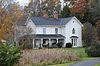 | February 22, 2011 (#11000033) | 18254 Providence Rd. 36°41′08″N 82°02′28″W / 36.685556°N 82.041111°W / 36.685556; -82.041111 (Baker-St. John House) | Abingdon | |
4 | Brook Hall |  | June 5, 1997 (#97000490) | 13160 Byars Ln. 36°45′47″N 81°48′10″W / 36.763056°N 81.802778°W / 36.763056; -81.802778 (Brook Hall) | Glade Spring | |
5 | Crabtree-Blackwell Farm |  | April 1, 1975 (#75002041) | 1 mile south of Blackwell on Moore Creek Rd. 36°49′04″N 81°51′12″W / 36.817778°N 81.853333°W / 36.817778; -81.853333 (Crabtree-Blackwell Farm) | Blackwell | |
6 | Edmondson Hall | 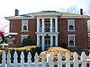 | June 11, 1998 (#98000697) | Lindell Rd., 0.25 miles north of the junction of State Route 80 and the Hillman Highway 36°45′45″N 81°51′52″W / 36.762500°N 81.864444°W / 36.762500; -81.864444 (Edmondson Hall) | Meadowview | |
7 | Emory and Henry College |  | January 30, 1989 (#85003695) | Oxford Ave. 36°46′21″N 81°49′55″W / 36.772500°N 81.831944°W / 36.772500; -81.831944 (Emory and Henry College) | Emory | |
8 | Glade Spring Commercial Historic District |  | May 28, 2013 (#13000345) | Portions of Town Square St., Grace St., E. Glade St., and Hemlock St. 36°47′26″N 81°46′16″W / 36.790556°N 81.771111°W / 36.790556; -81.771111 (Glade Spring Commercial Historic District) | Glade Spring | Twenty-two contributing buildings and one contributing structure.[6] |
9 | The Grove |  | May 16, 2002 (#02000525) | 14071 U.S. Routes 11/19 36°38′27″N 82°06′34″W / 36.640833°N 82.109444°W / 36.640833; -82.109444 (The Grove) | Bristol | |
10 | Mont Calm |  | July 18, 1974 (#74002148) | West of State Route 75 36°42′27″N 81°58′24″W / 36.707500°N 81.973333°W / 36.707500; -81.973333 (Mont Calm) | Abingdon | |
11 | Moonlite Theatre |  | August 8, 2007 (#07000802) | 17555 U.S. Routes 11/19 36°40′35″N 82°02′55″W / 36.676389°N 82.048611°W / 36.676389; -82.048611 (Moonlite Theatre) | Abingdon | Drive-in theater built in 1949. |
12 | Dr. William H. Pitts House |  | April 1, 2002 (#02000322) | 247 E. Main St. 36°42′47″N 81°58′07″W / 36.712917°N 81.968611°W / 36.712917; -81.968611 (Dr. William H. Pitts House) | Abingdon | |
13 | Retirement and the Muster Grounds |  | May 11, 2018 (#100002441) | 702 Colonial Rd. SW 36°42′14″N 81°59′39″W / 36.7039°N 81.9943°W / 36.7039; -81.9943 (Retirement and the Muster Grounds) | Abingdon | |
14 | Saltville Battlefields Historic District |  | March 25, 2010 (#10000096) | State Routes 91 and 107, and Cedar Branch Rd. 36°52′00″N 81°46′48″W / 36.866667°N 81.780000°W / 36.866667; -81.780000 (Saltville Battlefields Historic District) | Saltville | Extends into Smyth County |
15 | Walnut Grove |  | August 11, 2004 (#04000840) | 14081 U.S. Routes 11/19 36°38′16″N 82°07′06″W / 36.637639°N 82.118333°W / 36.637639; -82.118333 (Walnut Grove) | Bristol | |
16 | White's Mill | 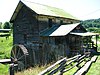 | September 10, 1974 (#74002149) | Northwest of Abingdon on White Mill Rd. 36°46′05″N 81°59′17″W / 36.768056°N 81.988056°W / 36.768056; -81.988056 (White's Mill) | Abingdon |
See also[edit]
| Wikimedia Commons has media related to National Register of Historic Places in Washington County, Virginia. |
- List of National Historic Landmarks in Virginia
- National Register of Historic Places listings in Virginia
- National Register of Historic Places listings in Bristol, Virginia
References[edit]
^ The latitude and longitude information provided in this table was derived originally from the National Register Information System, which has been found to be fairly accurate for about 99% of listings. For about 1% of NRIS original coordinates, experience has shown that one or both coordinates are typos or otherwise extremely far off; some corrections may have been made. A more subtle problem causes many locations to be off by up to 150 yards, depending on location in the country: most NRIS coordinates were derived from tracing out latitude and longitudes from USGS topographical quadrant maps created under the North American Datum of 1927, which differs from the current, highly accurate WGS84 GPS system used by most on-line maps. Chicago is about right, but NRIS longitudes in Washington are higher by about 4.5 seconds, and are lower by about 2.0 seconds in Maine. Latitudes differ by about 1.0 second in Florida. Some locations in this table may have been corrected to current GPS standards.
^ "National Register of Historic Places: Weekly List Actions". National Park Service, United States Department of the Interior. Retrieved on November 2, 2018.
^ Numbers represent an ordering by significant words. Various colorings, defined here, differentiate National Historic Landmarks and historic districts from other NRHP buildings, structures, sites or objects.
^ National Park Service (2008-04-24). "National Register Information System". National Register of Historic Places. National Park Service..mw-parser-output cite.citationfont-style:inherit.mw-parser-output qquotes:"""""""'""'".mw-parser-output code.cs1-codecolor:inherit;background:inherit;border:inherit;padding:inherit.mw-parser-output .cs1-lock-free abackground:url("//upload.wikimedia.org/wikipedia/commons/thumb/6/65/Lock-green.svg/9px-Lock-green.svg.png")no-repeat;background-position:right .1em center.mw-parser-output .cs1-lock-limited a,.mw-parser-output .cs1-lock-registration abackground:url("//upload.wikimedia.org/wikipedia/commons/thumb/d/d6/Lock-gray-alt-2.svg/9px-Lock-gray-alt-2.svg.png")no-repeat;background-position:right .1em center.mw-parser-output .cs1-lock-subscription abackground:url("//upload.wikimedia.org/wikipedia/commons/thumb/a/aa/Lock-red-alt-2.svg/9px-Lock-red-alt-2.svg.png")no-repeat;background-position:right .1em center.mw-parser-output .cs1-subscription,.mw-parser-output .cs1-registrationcolor:#555.mw-parser-output .cs1-subscription span,.mw-parser-output .cs1-registration spanborder-bottom:1px dotted;cursor:help.mw-parser-output .cs1-hidden-errordisplay:none;font-size:100%.mw-parser-output .cs1-visible-errorfont-size:100%.mw-parser-output .cs1-subscription,.mw-parser-output .cs1-registration,.mw-parser-output .cs1-formatfont-size:95%.mw-parser-output .cs1-kern-left,.mw-parser-output .cs1-kern-wl-leftpadding-left:0.2em.mw-parser-output .cs1-kern-right,.mw-parser-output .cs1-kern-wl-rightpadding-right:0.2em
^ The eight-digit number below each date is the number assigned to each location in the National Register Information System database, which can be viewed by clicking the number.
^ NPS
U.S. National Register of Historic Places in Virginia | ||
|---|---|---|
| Lists by county |
|   |
| Lists by city |
| |
| Other lists |
| |
| ||
Municipalities and communities of Washington County, Virginia, United States | ||
|---|---|---|
County seat: Abingdon | ||
| Towns |
|  |
| CDPs |
| |
| Unincorporated communities |
| |
| Footnotes | ‡This populated place also has portions in an adjacent county or counties | |
Categories:
- National Register of Historic Places in Washington County, Virginia
- Lists of National Register of Historic Places in Virginia by county
(window.RLQ=window.RLQ||).push(function()mw.config.set("wgPageParseReport":"limitreport":"cputime":"0.516","walltime":"0.637","ppvisitednodes":"value":7188,"limit":1000000,"ppgeneratednodes":"value":0,"limit":1500000,"postexpandincludesize":"value":155183,"limit":2097152,"templateargumentsize":"value":9795,"limit":2097152,"expansiondepth":"value":11,"limit":40,"expensivefunctioncount":"value":0,"limit":500,"unstrip-depth":"value":1,"limit":20,"unstrip-size":"value":5871,"limit":5000000,"entityaccesscount":"value":1,"limit":400,"timingprofile":["100.00% 434.202 1 -total"," 46.22% 200.710 16 Template:NRHP_row"," 28.88% 125.407 1 Template:NRHP_header"," 23.22% 100.831 1 Template:NRISref"," 22.41% 97.307 1 Template:Cite_web"," 10.72% 46.535 17 Template:Designation/color"," 9.84% 42.727 19 Template:NRHP_color"," 9.80% 42.546 32 Template:First_word"," 9.68% 42.042 16 Template:Coord"," 8.67% 37.640 17 Template:Dts"],"scribunto":"limitreport-timeusage":"value":"0.152","limit":"10.000","limitreport-memusage":"value":3450715,"limit":52428800,"cachereport":"origin":"mw1305","timestamp":"20181112220705","ttl":1900800,"transientcontent":false);mw.config.set("wgBackendResponseTime":92,"wgHostname":"mw1246"););


