National Register of Historic Places listings in Westmoreland County, Virginia
[dummy-text]
National Register of Historic Places listings in Westmoreland County, Virginia
Jump to navigation
Jump to search

Location of Westmoreland County in Virginia
This is a list of the National Register of Historic Places listings in Westmoreland County, Virginia.
This is intended to be a complete list of the properties and districts on the National Register of Historic Places in Westmoreland County, Virginia, United States. The locations of National Register properties and districts for which the latitude and longitude coordinates are included below, may be seen in a Google map.[1]
There are 22 properties and districts listed on the National Register in the county, including 2 National Historic Landmarks.
This National Park Service list is complete through NPS recent listings posted November 2, 2018.[2]
Current listings[edit]
| [3] | Name on the Register[4] | Image | Date listed[5] | Location | City or town | Description |
|---|---|---|---|---|---|---|
1 | Bell House |  | September 21, 1987 (#87000692) | 821 Irving Ave. 38°14′27″N 76°57′27″W / 38.240833°N 76.957500°W / 38.240833; -76.957500 (Bell House) | Colonial Beach | |
2 | Blenheim | 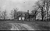 | June 5, 1975 (#75002042) | North of Wakefield Corner off State Route 204 38°10′51″N 76°56′56″W / 38.180833°N 76.948750°W / 38.180833; -76.948750 (Blenheim) | Wakefield Corner | |
3 | Bushfield |  | February 11, 2004 (#04000053) | 367 Club House Loop 38°08′00″N 76°42′50″W / 38.133333°N 76.713889°W / 38.133333; -76.713889 (Bushfield) | Mount Holly | |
4 | Chantilly | 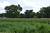 | December 16, 1971 (#71000990) | Address Restricted | Montross | |
5 | Ingleside |  | March 15, 1979 (#79003094) | South of Oak Grove on Leedstown Rd. 38°09′01″N 77°00′14″W / 38.150278°N 77.003889°W / 38.150278; -77.003889 (Ingleside) | Oak Grove | |
6 | Armstead T. Johnson High School |  | August 14, 1998 (#98001071) | 0.2 miles northwest of the junction of State Routes 3 and 202 38°04′39″N 76°46′54″W / 38.077500°N 76.781667°W / 38.077500; -76.781667 (Armstead T. Johnson High School) | Montross | |
7 | Morgan Jones 1677 Pottery Kiln | 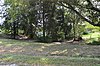 | October 16, 1974 (#74002150) | Southwestern section of the Glebe Harbor subdivision peninsula[6] 38°08′01″N 76°39′13″W / 38.133611°N 76.653611°W / 38.133611; -76.653611 (Morgan Jones 1677 Pottery Kiln) | Hague | |
8 | Kinsale Historic District | 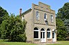 | July 22, 2005 (#05000476) | Roughly along Kinsale Rd., Kinsale Bridge Rd., Sigouney Dr., Great House Rd., and Yeocomico Ln. 38°01′46″N 76°34′48″W / 38.029444°N 76.580000°W / 38.029444; -76.580000 (Kinsale Historic District) | Kinsale | |
9 | James Monroe Family Home Site |  | July 24, 1979 (#79003095) | 4460 State Route 205 38°14′31″N 76°59′25″W / 38.241944°N 76.990278°W / 38.241944; -76.990278 (James Monroe Family Home Site) | Colonial Beach | Specific location represents a boundary increase of April 10, 2008; the site was originally listed as "Address Restricted" |
10 | Mount Pleasant |  | November 27, 2002 (#02001440) | 317 Coles Point Rd. 38°04′32″N 76°38′41″W / 38.075417°N 76.644722°W / 38.075417; -76.644722 (Mount Pleasant) | Hague | |
11 | Panorama |  | January 31, 2011 (#10001186) | 1006 Panorama Rd. 38°06′09″N 76°50′33″W / 38.102500°N 76.842500°W / 38.102500; -76.842500 (Panorama) | Montross | |
12 | Rochester House | January 25, 1991 (#90002205) | Beulah Ln., 1 mile (1.6 km) northeast of Lyells off State Route 3 38°00′05″N 76°43′02″W / 38.001389°N 76.717222°W / 38.001389; -76.717222 (Rochester House) | Lyells | ||
13 | Roxbury | 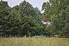 | March 15, 1979 (#79003096) | 1.7 miles (2.7 km) south of Oak Grove 38°09′27″N 77°00′10″W / 38.157500°N 77.002778°W / 38.157500; -77.002778 (Roxbury) | Oak Grove | |
14 | St. Peter's Episcopal Church | 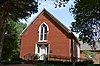 | January 16, 2004 (#03001445) | Junction of State Routes 3 and 205 38°10′56″N 76°59′45″W / 38.182222°N 76.995833°W / 38.182222; -76.995833 (St. Peter's Episcopal Church) | Oak Grove | |
15 | SIELE (motor yacht) |  | November 12, 1998 (#98001310) | Colonial Beach Yacht Center 38°13′56″N 76°57′56″W / 38.232222°N 76.965417°W / 38.232222; -76.965417 (SIELE (motor yacht)) | Colonial Beach | |
16 | Spence's Point |  | November 11, 1971 (#71000991) | On Sandy Point Neck, on Spences Point Rd. 38°05′13″N 76°33′46″W / 38.087083°N 76.562778°W / 38.087083; -76.562778 (Spence's Point) | Westmoreland | |
17 | Spring Grove |  | October 10, 1985 (#85003130) | State Route 202 38°05′10″N 76°42′22″W / 38.086111°N 76.706111°W / 38.086111; -76.706111 (Spring Grove) | Mount Holly | |
18 | Stratford Hall |  | October 15, 1966 (#66000851) | North of Lerty on State Route 214 38°09′07″N 76°50′22″W / 38.151944°N 76.839444°W / 38.151944; -76.839444 (Stratford Hall) | Lerty | |
19 | George Washington Birthplace National Monument |  | October 15, 1966 (#66000850) | East of Fredericksburg off U.S. Route 301 and State Route 3 38°11′09″N 76°55′05″W / 38.185833°N 76.918056°W / 38.185833; -76.918056 (George Washington Birthplace National Monument) | Colonial Beach | |
20 | Westmoreland State Park Historic District |  | November 16, 2005 (#05001265) | 1650 State Park Rd. 38°10′12″N 76°51′46″W / 38.170000°N 76.862778°W / 38.170000; -76.862778 (Westmoreland State Park Historic District) | Montross | |
21 | Wirtland |  | March 15, 1979 (#79003097) | South of Oak Grove on Leedstown Rd. 38°09′23″N 77°00′28″W / 38.156389°N 77.007778°W / 38.156389; -77.007778 (Wirtland) | Oak Grove | |
22 | Yeocomico Church | 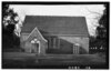 | November 12, 1969 (#69000331) | Old Yeocomico Rd. 38°03′45″N 76°35′49″W / 38.062500°N 76.596944°W / 38.062500; -76.596944 (Yeocomico Church) | Tucker Hill |
See also[edit]
| Wikimedia Commons has media related to National Register of Historic Places in Westmoreland County, Virginia. |
- List of National Historic Landmarks in Virginia
- National Register of Historic Places listings in Virginia
References[edit]
^ The latitude and longitude information provided in this table was derived originally from the National Register Information System, which has been found to be fairly accurate for about 99% of listings. For about 1% of NRIS original coordinates, experience has shown that one or both coordinates are typos or otherwise extremely far off; some corrections may have been made. A more subtle problem causes many locations to be off by up to 150 yards, depending on location in the country: most NRIS coordinates were derived from tracing out latitude and longitudes from USGS topographical quadrant maps created under the North American Datum of 1927, which differs from the current, highly accurate WGS84 GPS system used by most on-line maps. Chicago is about right, but NRIS longitudes in Washington are higher by about 4.5 seconds, and are lower by about 2.0 seconds in Maine. Latitudes differ by about 1.0 second in Florida. Some locations in this table may have been corrected to current GPS standards.
^ "National Register of Historic Places: Weekly List Actions". National Park Service, United States Department of the Interior. Retrieved on November 2, 2018.
^ Numbers represent an ordering by significant words. Various colorings, defined here, differentiate National Historic Landmarks and historic districts from other NRHP buildings, structures, sites or objects.
^ National Park Service (2008-04-24). "National Register Information System". National Register of Historic Places. National Park Service..mw-parser-output cite.citationfont-style:inherit.mw-parser-output qquotes:"""""""'""'".mw-parser-output code.cs1-codecolor:inherit;background:inherit;border:inherit;padding:inherit.mw-parser-output .cs1-lock-free abackground:url("//upload.wikimedia.org/wikipedia/commons/thumb/6/65/Lock-green.svg/9px-Lock-green.svg.png")no-repeat;background-position:right .1em center.mw-parser-output .cs1-lock-limited a,.mw-parser-output .cs1-lock-registration abackground:url("//upload.wikimedia.org/wikipedia/commons/thumb/d/d6/Lock-gray-alt-2.svg/9px-Lock-gray-alt-2.svg.png")no-repeat;background-position:right .1em center.mw-parser-output .cs1-lock-subscription abackground:url("//upload.wikimedia.org/wikipedia/commons/thumb/a/aa/Lock-red-alt-2.svg/9px-Lock-red-alt-2.svg.png")no-repeat;background-position:right .1em center.mw-parser-output .cs1-subscription,.mw-parser-output .cs1-registrationcolor:#555.mw-parser-output .cs1-subscription span,.mw-parser-output .cs1-registration spanborder-bottom:1px dotted;cursor:help.mw-parser-output .cs1-hidden-errordisplay:none;font-size:100%.mw-parser-output .cs1-visible-errorfont-size:100%.mw-parser-output .cs1-subscription,.mw-parser-output .cs1-registration,.mw-parser-output .cs1-formatfont-size:95%.mw-parser-output .cs1-kern-left,.mw-parser-output .cs1-kern-wl-leftpadding-left:0.2em.mw-parser-output .cs1-kern-right,.mw-parser-output .cs1-kern-wl-rightpadding-right:0.2em
^ The eight-digit number below each date is the number assigned to each location in the National Register Information System database, which can be viewed by clicking the number.
^ Kelson, William M., and Edward A. Chappell. "Excavation of a Seventeenth Century Pottery Kiln at Glebe Harbor, Westmoreland County, Virginia". Historical Archaeology 8 (1974), 53-63: 53.
U.S. National Register of Historic Places in Virginia | ||
|---|---|---|
| Lists by county |
|   |
| Lists by city |
| |
| Other lists |
| |
| ||
Municipalities and communities of Westmoreland County, Virginia, United States | ||
|---|---|---|
County seat: Montross | ||
| Towns |
|  |
| Unincorporated communities |
| |
Categories:
- National Register of Historic Places in Westmoreland County, Virginia
- Lists of National Register of Historic Places in Virginia by county
(window.RLQ=window.RLQ||).push(function()mw.config.set("wgPageParseReport":"limitreport":"cputime":"0.500","walltime":"0.648","ppvisitednodes":"value":9689,"limit":1000000,"ppgeneratednodes":"value":0,"limit":1500000,"postexpandincludesize":"value":192035,"limit":2097152,"templateargumentsize":"value":14997,"limit":2097152,"expansiondepth":"value":11,"limit":40,"expensivefunctioncount":"value":0,"limit":500,"unstrip-depth":"value":1,"limit":20,"unstrip-size":"value":6096,"limit":5000000,"entityaccesscount":"value":1,"limit":400,"timingprofile":["100.00% 430.668 1 -total"," 55.28% 238.068 22 Template:NRHP_row"," 20.80% 89.570 1 Template:NRHP_header"," 16.55% 71.267 1 Template:NRISref"," 15.79% 67.996 1 Template:Cite_web"," 10.99% 47.318 23 Template:Designation/color"," 9.78% 42.115 45 Template:First_word"," 9.69% 41.732 24 Template:NRHP_color"," 9.60% 41.336 21 Template:Coord"," 8.03% 34.595 1 Template:Commons_category"],"scribunto":"limitreport-timeusage":"value":"0.147","limit":"10.000","limitreport-memusage":"value":5768349,"limit":52428800,"cachereport":"origin":"mw1256","timestamp":"20181112214138","ttl":1900800,"transientcontent":false);mw.config.set("wgBackendResponseTime":82,"wgHostname":"mw1258"););


