National Register of Historic Places listings in Danville, Virginia
[dummy-text]
National Register of Historic Places listings in Danville, Virginia
Jump to navigation
Jump to search

Location of Danville in Virginia
This is a list of the National Register of Historic Places listings in Danville, Virginia.
This is intended to be a complete list of the properties and districts on the National Register of Historic Places in the independent city of Danville, Virginia, United States. The locations of National Register properties and districts for which the latitude and longitude coordinates are included below, may be seen in an online map.[1]
There are 19 properties and districts listed on the National Register in the city. Another property was once listed but has been removed.
This National Park Service list is complete through NPS recent listings posted November 2, 2018.[2]
Current listings[edit]
| [3] | Name on the Register[4] | Image | Date listed[5] | Location | Description |
|---|---|---|---|---|---|
1 | Dan River Mill No. 8 |  | March 24, 2010 (#10000095) | 424 Memorial Dr. 36°35′30″N 79°23′41″W / 36.591667°N 79.394722°W / 36.591667; -79.394722 (Dan River Mill No. 8) | |
2 | Dan's Hill |  | May 30, 1979 (#79003067) | 4 miles (6.4 km) west of downtown Danville 36°35′29″N 79°28′41″W / 36.591250°N 79.478056°W / 36.591250; -79.478056 (Dan's Hill) | |
3 | Danville Historic District |  | April 11, 1973 (#73002207) | Roughly bounded by Main, Green, and Paxton Sts., and Memorial Hospital; also Jefferson Ave., Chestnut Pl., Grove, Chambers, and the 100 blocks of Ross and Holbrook Sts. 36°34′55″N 79°24′00″W / 36.581944°N 79.400000°W / 36.581944; -79.400000 (Danville Historic District) | Second set of addresses represent a boundary increase of August 24, 2015 |
4 | Danville Municipal Building |  | July 21, 1995 (#95000896) | 418 Patton St. 36°35′11″N 79°23′31″W / 36.586389°N 79.391944°W / 36.586389; -79.391944 (Danville Municipal Building) | |
5 | Danville National Cemetery |  | April 7, 1995 (#95000274) | 721 Lee St. 36°34′37″N 79°23′22″W / 36.576944°N 79.389444°W / 36.576944; -79.389444 (Danville National Cemetery) | |
6 | Danville Public Library | 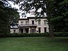 | November 12, 1969 (#69000338) | 975 Main St. 36°34′52″N 79°24′00″W / 36.581111°N 79.400000°W / 36.581111; -79.400000 (Danville Public Library) | |
7 | Danville Southern Railway Passenger Depot |  | July 21, 1995 (#95000895) | 701 Craghead St. 36°35′03″N 79°23′02″W / 36.584167°N 79.383889°W / 36.584167; -79.383889 (Danville Southern Railway Passenger Depot) | |
8 | Danville Tobacco Warehouse and Residential District |  | July 14, 1982 (#82004552) | Off U.S. Route 58 36°34′50″N 79°23′18″W / 36.580556°N 79.388333°W / 36.580556; -79.388333 (Danville Tobacco Warehouse and Residential District) | Boundary increase May 21, 2009 |
9 | Downtown Danville Historic District |  | August 12, 1993 (#93000830) | Roughly bounded by Memorial Dr. and High, Patton, and Ridge Sts. 36°35′16″N 79°23′32″W / 36.587778°N 79.392222°W / 36.587778; -79.392222 (Downtown Danville Historic District) | |
10 | Holbrook-Ross Street Historic District |  | November 18, 1997 (#97001404) | Roughly bounded by Holbrook, Ross, Gay, and Maury Sts. 36°35′12″N 79°24′10″W / 36.586667°N 79.402778°W / 36.586667; -79.402778 (Holbrook-Ross Street Historic District) | |
11 | Hotel Danville | 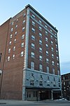 | December 6, 1984 (#84000658) | 600 Main St. 36°35′14″N 79°23′41″W / 36.587222°N 79.394722°W / 36.587222; -79.394722 (Hotel Danville) | |
12 | Hylton Hall |  | September 14, 2009 (#09000726) | 700 Lanier Ave. 36°34′04″N 79°25′34″W / 36.567778°N 79.426111°W / 36.567778; -79.426111 (Hylton Hall) | |
13 | Langhorne House | 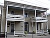 | February 1, 2006 (#05001586) | 117 Broad St. 36°34′49″N 79°24′12″W / 36.580139°N 79.403333°W / 36.580139; -79.403333 (Langhorne House) | |
14 | Main Street Methodist Episcopal Church South |  | December 6, 1990 (#90001822) | 767 Main St. 36°35′05″N 79°23′47″W / 36.584722°N 79.396389°W / 36.584722; -79.396389 (Main Street Methodist Episcopal Church South) | |
15 | Mechanicsville Historic District |  | May 19, 2014 (#14000231) | Floyd, High, N. Ridge, Monroe, and Upper Sts. 36°35′20″N 79°23′47″W / 36.588889°N 79.396389°W / 36.588889; -79.396389 (Mechanicsville Historic District) | |
16 | North Danville Historic District |  | January 15, 2004 (#03001432) | Roughly bounded by Riverside Dr., Claiborne St., the Leemont Cemetery, Novle Ave., and Scales St. 36°35′51″N 79°23′05″W / 36.5975°N 79.384722°W / 36.5975; -79.384722 (North Danville Historic District) | |
17 | Penn-Wyatt House |  | September 7, 1979 (#79003317) | 862 Main St. 36°35′00″N 79°23′56″W / 36.583333°N 79.398889°W / 36.583333; -79.398889 (Penn-Wyatt House) | |
18 | Schoolfield School Complex |  | June 3, 2009 (#09000392) | 31 Baltimore Ave. 36°34′03″N 79°25′26″W / 36.567500°N 79.423889°W / 36.567500; -79.423889 (Schoolfield School Complex) | |
19 | Schoolfield Welfare Building |  | March 1, 2011 (#11000064) | 917 W. Main St. 36°34′09″N 79°25′27″W / 36.569167°N 79.424167°W / 36.569167; -79.424167 (Schoolfield Welfare Building) |
Former listings[edit]
| [3] | Name on the Register | Image | Date listed | Date removed | Location | Summary |
|---|---|---|---|---|---|---|
1 | Dan River Inc. Riverside Division Historic District |  | May 11, 2000 (#00000480) | July 29, 2016 | Both sides of Dan River roughly bounded by Union St. Dam, Main St. Bridge, and Riverside and Memorial Drs.; also 424 Memorial Dr. 36°35′34″N 79°23′50″W / 36.592778°N 79.397222°W / 36.592778; -79.397222 (Dan River Inc. Riverside Division Historic District) | 424 Memorial represents Dan River Mill No. 8, a boundary increase of March 24, 2010 |
See also[edit]
| Wikimedia Commons has media related to National Register of Historic Places in Danville, Virginia. |
- List of National Historic Landmarks in Virginia
- National Register of Historic Places listings in Virginia
- National Register of Historic Places listings in Pittsylvania County, Virginia
References[edit]
^ The latitude and longitude information provided in this table was derived originally from the National Register Information System, which has been found to be fairly accurate for about 99% of listings. For about 1% of NRIS original coordinates, experience has shown that one or both coordinates are typos or otherwise extremely far off; some corrections may have been made. A more subtle problem causes many locations to be off by up to 150 yards, depending on location in the country: most NRIS coordinates were derived from tracing out latitude and longitudes from USGS topographical quadrant maps created under the North American Datum of 1927, which differs from the current, highly accurate WGS84 GPS system used by most on-line maps. Chicago is about right, but NRIS longitudes in Washington are higher by about 4.5 seconds, and are lower by about 2.0 seconds in Maine. Latitudes differ by about 1.0 second in Florida. Some locations in this table may have been corrected to current GPS standards.
^ "National Register of Historic Places: Weekly List Actions". National Park Service, United States Department of the Interior. Retrieved on November 2, 2018.
^ ab Numbers represent an ordering by significant words. Various colorings, defined here, differentiate National Historic Landmarks and historic districts from other NRHP buildings, structures, sites or objects.
^ National Park Service (2008-04-24). "National Register Information System". National Register of Historic Places. National Park Service..mw-parser-output cite.citationfont-style:inherit.mw-parser-output qquotes:"""""""'""'".mw-parser-output code.cs1-codecolor:inherit;background:inherit;border:inherit;padding:inherit.mw-parser-output .cs1-lock-free abackground:url("//upload.wikimedia.org/wikipedia/commons/thumb/6/65/Lock-green.svg/9px-Lock-green.svg.png")no-repeat;background-position:right .1em center.mw-parser-output .cs1-lock-limited a,.mw-parser-output .cs1-lock-registration abackground:url("//upload.wikimedia.org/wikipedia/commons/thumb/d/d6/Lock-gray-alt-2.svg/9px-Lock-gray-alt-2.svg.png")no-repeat;background-position:right .1em center.mw-parser-output .cs1-lock-subscription abackground:url("//upload.wikimedia.org/wikipedia/commons/thumb/a/aa/Lock-red-alt-2.svg/9px-Lock-red-alt-2.svg.png")no-repeat;background-position:right .1em center.mw-parser-output .cs1-subscription,.mw-parser-output .cs1-registrationcolor:#555.mw-parser-output .cs1-subscription span,.mw-parser-output .cs1-registration spanborder-bottom:1px dotted;cursor:help.mw-parser-output .cs1-hidden-errordisplay:none;font-size:100%.mw-parser-output .cs1-visible-errorfont-size:100%.mw-parser-output .cs1-subscription,.mw-parser-output .cs1-registration,.mw-parser-output .cs1-formatfont-size:95%.mw-parser-output .cs1-kern-left,.mw-parser-output .cs1-kern-wl-leftpadding-left:0.2em.mw-parser-output .cs1-kern-right,.mw-parser-output .cs1-kern-wl-rightpadding-right:0.2em
^ The eight-digit number below each date is the number assigned to each location in the National Register Information System database, which can be viewed by clicking the number.
U.S. National Register of Historic Places in Virginia | ||
|---|---|---|
| Lists by county |
|   |
| Lists by city |
| |
| Other lists |
| |
| ||
Categories:
- National Register of Historic Places in Danville, Virginia
- Lists of National Register of Historic Places in Virginia by city
(window.RLQ=window.RLQ||).push(function()mw.config.set("wgPageParseReport":"limitreport":"cputime":"0.504","walltime":"0.613","ppvisitednodes":"value":8427,"limit":1000000,"ppgeneratednodes":"value":0,"limit":1500000,"postexpandincludesize":"value":161741,"limit":2097152,"templateargumentsize":"value":10725,"limit":2097152,"expansiondepth":"value":11,"limit":40,"expensivefunctioncount":"value":0,"limit":500,"unstrip-depth":"value":1,"limit":20,"unstrip-size":"value":5793,"limit":5000000,"entityaccesscount":"value":1,"limit":400,"timingprofile":["100.00% 430.932 1 -total"," 55.70% 240.032 20 Template:NRHP_row"," 23.92% 103.099 1 Template:NRHP_header"," 18.69% 80.551 1 Template:NRISref"," 17.65% 76.061 1 Template:Cite_web"," 10.38% 44.731 21 Template:Designation/color"," 9.95% 42.875 20 Template:Coord"," 9.82% 42.316 23 Template:Dts"," 9.67% 41.669 38 Template:First_word"," 9.16% 39.477 26 Template:NRHP_color"],"scribunto":"limitreport-timeusage":"value":"0.159","limit":"10.000","limitreport-memusage":"value":6390137,"limit":52428800,"cachereport":"origin":"mw1337","timestamp":"20181112220716","ttl":1900800,"transientcontent":false);mw.config.set("wgBackendResponseTime":103,"wgHostname":"mw1267"););


