Vancouver City Centre station
Vancouver City Centre | |||||||||||
|---|---|---|---|---|---|---|---|---|---|---|---|
SkyTrain station | |||||||||||
 | |||||||||||
| Location | 702 West Georgia Street, Vancouver | ||||||||||
| Coordinates | 49°16′55″N 123°07′08″W / 49.28202°N 123.11875°W / 49.28202; -123.11875Coordinates: 49°16′55″N 123°07′08″W / 49.28202°N 123.11875°W / 49.28202; -123.11875 | ||||||||||
| Owned by | TransLink | ||||||||||
| Platforms | Centre platform | ||||||||||
| Tracks | 2 | ||||||||||
| Connections | |||||||||||
| Construction | |||||||||||
| Structure type | Subway | ||||||||||
| Disabled access | Yes | ||||||||||
| Other information | |||||||||||
| Station code | VS | ||||||||||
| Fare zone | 1 | ||||||||||
| History | |||||||||||
| Opened | August 17, 2009 | ||||||||||
| Traffic | |||||||||||
| Passengers (2017[1]) | 18,400 | ||||||||||
| Services | |||||||||||
| |||||||||||

Station entry with fare gates and Compass vending machines
Vancouver City Centre is a SkyTrain station on the Canada Line in Vancouver, British Columbia, Canada.
Contents
1 Location
2 Station information
2.1 Station layout
3 Services
3.1 Bus routes
3.1.1 Local
3.1.2 North Shore
3.1.3 NightBus
4 References
5 External links
Location

Construction progresses at Granville and Georgia Streets outside Sears.
Vancouver City Centre station is located on Granville Street, between West Georgia Street and Robson Street in Downtown Vancouver. The station serves the shopping and entertainment districts along Granville and Robson streets, and the office and shopping complexes of Pacific Centre and Vancouver Centre.
The station is also within walking distance of such amenities as Robson Square (home of the Vancouver Art Gallery, the Provincial Court of British Columbia, and a UBC satellite campus), the Orpheum Theatre, Vancouver Library Square, TD Tower, Scotia Tower and the HSBC Canada Building.
Station information
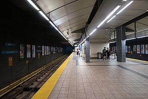
Station layout
| S | Street | Entrance at Georgia Street and Granville Street |
| C | Concourse | Connections to Pacific Centre and Vancouver Centre Compass Ticket vending machines, fare gates |
| T | Platform 1 Inbound | ← ■ Canada Line towards Waterfront (Terminus) |
Island platform; doors will open on the left | ||
| Platform 2 Outbound | ■ Canada Line towards Richmond–Brighouse and YVR–Airport (Yaletown–Roundhouse) → | |
Services
The station is located within short walking distance of bus stops for bus services throughout Vancouver (especially the trolleybus services on Granville Mall) and to the North Shore. There are underground connections between Vancouver City Centre and both the Pacific Centre and Vancouver Centre shopping malls. Passengers are able to transfer between Vancouver City Centre station and Granville station (on the Expo Line) during regular retail hours by walking through Pacific Centre or Vancouver Centre and The Bay department store, although the only direct transfer point between the Canada Line and the Expo Line is at Waterfront station.
Bus routes
The following bus routes can be found in close proximity to Vancouver City Centre station:[2]
Local
- 4 UBC/Powell
- 7 Dunbar / Nanaimo Station
- 10 Granville
- 14 UBC
- 16 Arbutus / 29th Avenue Station
- 17 Oak
- 20 Victoria
- 50 False Creek South
North Shore
- 240 15th Street
- 241 Upper Lonsdale (peak only)
- 242 Lynn Valley (weekend early mornings)
- 246 Highland
- 247 Upper Capilano (peak only)
- 250 Horseshoe Bay
- 250A Dundarave
- 253 Caulfield (peak only)
- 254 British Properties (peak only)
- 257 Horseshoe Bay Express
NightBus
- N8 Fraser
- N9 Coquitlam Central Station
- N10 Brighouse Station
- N15 Cambie
- N17 UBC
- N19 Surrey Central Station
- N20 Victoria
- N22 Macdonald
- N24 Lynn Valley
- N35 SFU
References
^ "2017 Transit Service Performance Review" (PDF). translink.ca. TransLink. Retrieved June 28, 2018..mw-parser-output cite.citationfont-style:inherit.mw-parser-output qquotes:"""""""'""'".mw-parser-output code.cs1-codecolor:inherit;background:inherit;border:inherit;padding:inherit.mw-parser-output .cs1-lock-free abackground:url("//upload.wikimedia.org/wikipedia/commons/thumb/6/65/Lock-green.svg/9px-Lock-green.svg.png")no-repeat;background-position:right .1em center.mw-parser-output .cs1-lock-limited a,.mw-parser-output .cs1-lock-registration abackground:url("//upload.wikimedia.org/wikipedia/commons/thumb/d/d6/Lock-gray-alt-2.svg/9px-Lock-gray-alt-2.svg.png")no-repeat;background-position:right .1em center.mw-parser-output .cs1-lock-subscription abackground:url("//upload.wikimedia.org/wikipedia/commons/thumb/a/aa/Lock-red-alt-2.svg/9px-Lock-red-alt-2.svg.png")no-repeat;background-position:right .1em center.mw-parser-output .cs1-subscription,.mw-parser-output .cs1-registrationcolor:#555.mw-parser-output .cs1-subscription span,.mw-parser-output .cs1-registration spanborder-bottom:1px dotted;cursor:help.mw-parser-output .cs1-hidden-errordisplay:none;font-size:100%.mw-parser-output .cs1-visible-errorfont-size:100%.mw-parser-output .cs1-subscription,.mw-parser-output .cs1-registration,.mw-parser-output .cs1-formatfont-size:95%.mw-parser-output .cs1-kern-left,.mw-parser-output .cs1-kern-wl-leftpadding-left:0.2em.mw-parser-output .cs1-kern-right,.mw-parser-output .cs1-kern-wl-rightpadding-right:0.2em
^ "Granville Station & Vancouver City Centre Station Map" (PDF). TransLink. Retrieved 25 August 2015.
External links
| Wikimedia Commons has media related to Vancouver City Center Station. |
TransLink services in Metro Vancouver | |||||||||||||||
|---|---|---|---|---|---|---|---|---|---|---|---|---|---|---|---|
| |||||||||||||||
| |||||||||||||||
| |||||||||||||||
| |||||||||||||||
| |||||||||||||||
