Rabat
Rabat الرِّبَاط ⴰⵕⴱⴰⵟ | |||
|---|---|---|---|
City | |||
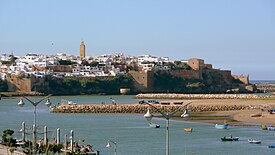      Clockwise from top: River Bou Regreg and the Kasbah of the Udayas, Dâr-al-Makhzen the main royal residence, Hassan Tower, Chellah Necropolis, Kasbah of the Udayas, Mausoleum of Mohammed V | |||
| |||
 Rabat Location in Morocco & Africa Show map of Morocco  Rabat Rabat (Africa) Show map of Africa | |||
| Coordinates: 34°02′N 6°50′W / 34.033°N 6.833°W / 34.033; -6.833[1] | |||
| Country | Morocco | ||
| Region | Rabat-Salé-Kénitra | ||
| Founded by Almohads | 1146 | ||
| Government | |||
| • Mayor | Mohamed Sadiki | ||
| Area | |||
| • City | 117 km2 (45.17 sq mi) | ||
| Highest elevation | 160 m (520 ft) | ||
| Lowest elevation | 0 m (0 ft) | ||
| Population (2014)[2] | |||
| • City | 577,827 | ||
| • Rank | 7th in Morocco | ||
| • Density | 4,900/km2 (13,000/sq mi) | ||
| • Metro | 2,120,192 | ||
| Time zone | UTC+1 (CET) | ||
| Website | www.rabat.ma | ||
UNESCO World Heritage Site | |||
| Official name | Rabat, Modern Capital and Historic City: a Shared Heritage | ||
| Type | Cultural | ||
| Criteria | ii, iv | ||
| Designated | 2012 (36th session) | ||
| Reference no. | 1401 | ||
| State Party | Morocco | ||
| Region | Arab States | ||

Rabat (Arabic: الرِّبَاط, al-ribāṭ; Berber languages: ⴰⵕⴱⴰⵟ Aṛṛbaṭ) is the capital city of Morocco and the country's seventh largest city with an urban population of approximately 580,000 (2014)[2] and a metropolitan population of over 1.2 million. It is also the capital city of the Rabat-Salé-Kénitra administrative region.[3]
Once a reputed corsair haven, Rabat served as one of the many ports in North Africa for the Barbary pirates, who were particularly active from the 16th through the 18th centuries.T he city is located on the Atlantic Ocean at the mouth of the river Bou Regreg. On the facing shore of the river lies Salé, the city's main commuter town. Rabat, Temara, and Salé form a conurbation of over 1.8 million people. Silt-related problems have diminished Rabat's role as a port; however, Rabat, and Salé still maintain important textile, food processing and construction industries. In addition, tourism and the presence of all foreign embassies in Morocco serve to make Rabat one of the most important cities in the country. The Moroccan capital was ranked at second place by CNN in its "Top Travel Destinations of 2013".[4] It is one of four Imperial cities of Morocco, and the medina of Rabat is listed as a World Heritage Site. Rabat is accessible by train through the ONCF system and by plane through the nearby Rabat–Salé Airport.
Contents
1 History
1.1 12th to 17th century
1.2 Corsair republics
1.3 20th century
1.3.1 French invasion
1.3.2 Post World War II
2 Neighbourhoods of Rabat
3 Bouregreg Marina
4 Subdivisions
5 Families of Rabat
6 Climate
7 Culture
7.1 Mawazine
8 Main sights
9 Notable people from Rabat
10 Transport
10.1 Air
10.2 Trains
10.3 Tram
11 Sports
11.1 Football
11.2 Handball
11.3 Basketball
11.4 Volleyball
12 Gallery
13 International relations
13.1 Twin towns—sister cities
14 References
15 Bibliography
16 External links
History

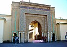
Bab Oudaia gate
12th to 17th century
Rabat has a relatively modern history compared to the nearby ancient city of Salé. In 1146, the Almohad ruler Abd al-Mu'min[5] turned Rabat's ribat into a full-scale fortress to use as a launching point for attacks on Iberia. In 1170, due to its military importance, Rabat acquired the title Ribatu l-Fath, meaning "stronghold of victory," from which it derives its current name.[6]
Yaqub al-Mansur (known as Moulay Yacoub in Morocco), another Almohad Caliph, moved the capital of his empire to Rabat.[7] He built Rabat's city walls, the Kasbah of the Udayas and began construction on what would have been the world's largest mosque. However, Yaqub died and construction stopped. The ruins of the unfinished mosque, along with the Hassan Tower, still stand today.
Yaqub's death initiated a period of decline. The Almohad empire lost control of its possessions in Spain and much of its African territory, eventually leading to its total collapse. In the 13th century, much of Rabat's economic power shifted to Fez. In 1515 a Moorish explorer, El Wassan, reported that Rabat had declined so much that only 100 inhabited houses remained. An influx of Moriscos, who had been expelled from Spain, in the early 17th century helped boost Rabat's growth.
Corsair republics
Rabat and neighboring Salé united to form the Republic of Bou Regreg in 1627[8]. The republic was run by Barbary pirates who used the two cities as base ports for launching attacks on shipping. The pirates did not have to contend with any central authority until the Alaouite Dynasty united Morocco in 1666. The latter attempted to establish control over the pirates, but failed. European and Muslim authorities continued to attempt to control the pirates over many years, but the Republic of Bou Regreg did not collapse until 1818. Even after the republic's collapse, pirates continued to use the port of Rabat, which led to the shelling of the city by Austria in 1829 after an Austrian ship had been lost to a pirate attack.
20th century
French invasion
The French invaded Morocco in 1912[9] and established a protectorate. The French administrator of Morocco, General Hubert Lyautey,[10] decided to relocate the country's capital from Fez to Rabat. Among other factors, rebellious citizens had made Fez an unstable place. Sultan Moulay Youssef followed the decision of the French and moved his residence to Rabat. In 1913, Gen. Lyautey hired Henri Prost who designed the Ville Nouvelle (Rabat's modern quarter) as an administrative sector. When Morocco achieved independence in 1955, Mohammed V, the then King of Morocco, chose to have the capital remain at Rabat.
Post World War II
Following World War II, the United States established a military presence in Rabat at the former French air base. By the early 1950s, Rabat Salé Air Base was a U.S. Air Force installation hosting the 17th Air Force and the 5th Air Division, which oversaw forward basing for Strategic Air Command (SAC) B-47 Stratojet aircraft in the country. With the destabilization of French government in Morocco, and Moroccan independence in 1956, the government of Mohammed V wanted the U.S. Air Force to pull out of the SAC bases in Morocco, insisting on such action after American intervention in Lebanon in 1958. The United States agreed to leave as of December 1959, and was fully out of Morocco by 1963. SAC felt the Moroccan bases were much less critical with the long range capability of the B-52 Stratofortresses that were replacing the B-47s and with the completion of the USAF installations in Spain in 1959.[11]
With the USAF withdrawal from Rabat-Salé in the 1960s, the facility became a primary facility for the Royal Moroccan Air Force known as Air Base Nº 1, a status it continues to hold.
Neighbourhoods of Rabat

The headquarters of Maroc Telecom
Rabat is an administrative city. It does have many shopping districts and residential neighbourhoods. The geographically spread out neighbourhoods are as follows:
The heart of the city consists of three parts: the Medina (old town); the Oudayas and Hassan both located to meet the Bou Regreg; and the Atlantic Ocean.
To the west, and along the waterfront, there is a succession of neighbourhoods.
First, around the ramparts, there is the old neighbourhoods, Quartier l'Océan and Quartier les Orangers. Beyond that, a succession of mostly working-class districts: Diour Jamaa, Akkari, Yacoub El Mansour, Massira and Hay el Fath are the main parts of this axis. Hay el Fath, which ends this sequence, evolves into a middle-class neighbourhood.
To the east, along the Bouregreg, the Youssoufia region: Mabella; Taqaddoum; Hay Nahda; Aviation; and Rommani (working and middle classes).
Between the two axes, from north to south, there are three main neighbourhoods (middle class to affluent): Agdal (Ward Building; a lively mix of residential and commercial buildings. The residents are predominantly upper middle class); Hay Riad (affluent villas; this neighbourhood has experienced a surge of momentum since the 2000s); and Souissi (residential neighborhood).
On the outskirts of Souissi, are a number of less-dense regions mainly comprising large private houses to areas that seem out of the city.[12]

Riad District
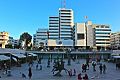
Pietri Square
Rabat Hassan

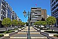
Avenue Mohammed V


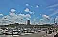
Bouregreg Marina
Located between the Atlantic and the Bouregreg Valley, this magnificent river marina is paved with famous historical sites like the esplanade of the Hassan Tower and the picturesque Chellah necropolis, which has witnessed many Mediterranean civilizations pass by.
Outfitted with the most modern equipment to host up to 240 boats, the Bouregreg Marina aims to become an essential destination for recreational boaters seeking long stays or just an unforgettable stopover on their way to West Africa, the Caribbean or the shores of North America.
Bouregreg Marina

Behind Tûranor PlanetSolar is a new Hassan II bridge between Rabat and Salé


Subdivisions
The prefecture is divided administratively into the following:[2]
| Name | Geographic code | Type | Households | Population (2014) | Foreign population | Moroccan population | Notes |
|---|---|---|---|---|---|---|---|
| Agdal Riyad | 421.01.01. | Arrondissement | 22,399 | 77,257 | 4,572 | 72,685 | |
| El Youssoufia | 421.01.03. | Arrondissement | 42,312 | 170,561 | 2,858 | 167,703 | |
| Hassan | 421.01.05. | Arrondissement | 32,848 | 108,179 | 2,151 | 106,025 | |
| Souissi | 421.01.06. | Arrondissement | 5,924 | 23,366 | 1,203 | 22,163 | |
| Touarga | 421.01.07. | Municipality | 812 | 3,932 | 8 | 3,924 | |
| Yacoub El Mansour | 421.01.09. | Arrondissement | 47,375 | 194,532 | 2,099 | 192,433 |
Families of Rabat
Called Rbatis, these families have lived for more than 400 years with many events in common. From the expulsion of the Moriscos to arrive at the foundation of a culture that combines the Arabic and Andalusian cultures, through the Republic of Bouregreg events than other families coming to live in Rabat recently, have not known.
Since its founding, Rabat was inhabited by several families from the High Atlas with Abu Yusuf Yaqub al-Mansur, who founded the city in 1198, then families from many parts of Morocco have settled. Rabat has around 1240 a few hundred fifty families whose families Chiadmi, Regragui, Loudiyi, etc.
Since the end of the thirteenth century, the city has had an influx of Moriscos expelled from Granada until 1609, the year of total expulsion of Muslims from Spain by Philip III. These families include: Bargach (Vargas); Guedira (Guadaira); Mouline (Molina); Sebbata (Zapata); and Frej.
The said families are considered, until today, as "Rbati's Families of strain". They are about four hundred families.
Other families in the city are considered residents of Rabat because they came at the time when Rabat became the capital of the country, either through rural exodus or to work in public administration based in the city since the establishment of the protectorate.
The city is on the territory of Zaer, an Arab tribe of Maqil origin. Leo Africanus in the early 16th century the signals in the region of Khenifra there, she continued on to the north to the Rabat region.
Climate
Rabat features a Mediterranean climate (Csa) with warm to hot dry summers and mild damp winters. Located along the Atlantic Ocean, Rabat has a mild, temperate climate, shifting from cool in winter to warm days in the summer months. The nights are always cool (or cold in winter, it can reach Sub 0 °C (32 °F) sometimes), with daytime temperatures generally rising about +7/8 C° (+15/18 F°). The winter highs typically reach only 17.2 °C (63.0 °F) in December–February. Summer daytime highs usually hover around 25 °C (77.0 °F), but may occasionally exceed 30 °C (86.0 °F), especially during heat waves. Summer nights are usually pleasant and cool, ranging between 11 °C (51.8 °F) and 19 °C (66.2 °F) and rarely exceeding 20 °C (68.0 °F). Rabat belongs to the sub-humid bioclimatic zone with an average annual precipitation of 560 mm.
Rabat's climate resembles the southwest coast of the Iberian Peninsula.
| Climate data for Rabat (Rabat–Salé Airport) 1961–1990, extremes 1943–present | |||||||||||||
|---|---|---|---|---|---|---|---|---|---|---|---|---|---|
| Month | Jan | Feb | Mar | Apr | May | Jun | Jul | Aug | Sep | Oct | Nov | Dec | Year |
| Record high °C (°F) | 30.0 (86) | 31.0 (87.8) | 35.8 (96.4) | 37.6 (99.7) | 43.0 (109.4) | 43.7 (110.7) | 47.2 (117) | 45.8 (114.4) | 42.3 (108.1) | 38.0 (100.4) | 35.1 (95.2) | 30.0 (86) | 47.2 (117) |
| Average high °C (°F) | 17.2 (63) | 17.7 (63.9) | 19.2 (66.6) | 20.0 (68) | 22.1 (71.8) | 24.1 (75.4) | 26.8 (80.2) | 27.1 (80.8) | 26.4 (79.5) | 24.0 (75.2) | 20.6 (69.1) | 17.7 (63.9) | 21.9 (71.4) |
| Daily mean °C (°F) | 12.6 (54.7) | 13.1 (55.6) | 14.2 (57.6) | 15.2 (59.4) | 17.4 (63.3) | 19.8 (67.6) | 22.2 (72) | 22.4 (72.3) | 21.5 (70.7) | 19.0 (66.2) | 15.9 (60.6) | 13.2 (55.8) | 17.2 (63) |
| Average low °C (°F) | 8.0 (46.4) | 8.6 (47.5) | 9.2 (48.6) | 10.4 (50.7) | 12.7 (54.9) | 15.4 (59.7) | 17.6 (63.7) | 17.7 (63.9) | 16.7 (62.1) | 14.1 (57.4) | 11.1 (52) | 8.7 (47.7) | 12.5 (54.5) |
| Record low °C (°F) | −3.2 (26.2) | −2.6 (27.3) | −0.4 (31.3) | 3.8 (38.8) | 5.3 (41.5) | 9.0 (48.2) | 10.0 (50) | 11.0 (51.8) | 10.0 (50) | 7.0 (44.6) | 0.0 (32) | 0.3 (32.5) | −3.2 (26.2) |
| Average precipitation mm (inches) | 77.2 (3.04) | 74.1 (2.92) | 60.9 (2.4) | 62.0 (2.44) | 25.3 (1) | 6.7 (0.26) | 0.5 (0.02) | 1.3 (0.05) | 5.7 (0.22) | 43.6 (1.72) | 96.7 (3.81) | 100.9 (3.97) | 554.9 (21.85) |
| Average precipitation days | 9.9 | 9.8 | 9.0 | 8.7 | 5.7 | 2.4 | 0.3 | 0.4 | 2.4 | 6.4 | 10.2 | 10.4 | 75.6 |
| Average relative humidity (%) | 82 | 82 | 80 | 78 | 77 | 78 | 78 | 79 | 80 | 79 | 80 | 83 | 80 |
| Mean monthly sunshine hours | 179.9 | 182.3 | 232.0 | 254.5 | 290.5 | 287.6 | 314.7 | 307.0 | 261.1 | 235.1 | 190.5 | 180.9 | 2,916.1 |
| Source #1: NOAA[13] | |||||||||||||
| Source #2: Deutscher Wetterdienst (humidity, 1973–1993),[14] Meteo Climat (record highs and lows)[15] | |||||||||||||
Culture

Hassan Tower

Hotel Balima

Mosquée As-Sounah

Saint-Pierre Cathedral


The biggest place for theatre is the Theatre Mohammed V in the centre of the town.
The city has a few official galleries and an archeological museum.
Many organizations are active in cultural and social issues. Orient-Occident Foundation and ONA Foundation are the biggest of these. An independent art scene is active in the city. L'appartement 22, which is the first independent space for visual arts created by Abdellah Karroum, opened in 2002 and introduced international and local artists. Other independent spaces opened few years after, such as Le Cube, also set up in a private space.
Mawazine
Mawazine is a music festival in Rabat welcomed by Mohammed VI King of Morocco, that started in 2001 where music groups, fans and spectators come together in a week-long celebration of culture and music both locally and internationally. Musicians such as Scorpions, Rihanna, Elton John, Stromae and many others have performed at the festival.
Mawazine was host to more than 2,500,000 in 2013. Workshops are available for teaching dances and other arts. The festival is free. However, while most areas are free, there are those that require payment, specifically the smaller stages being the historical site of Chellah, the Mohammed V National Theater, and the Renaissance Cultural Center.[16]
Main sights
- Mausoleum of Mohammed V
- Mohammed V University
- Hassan Tower
- Chellah Necropolis
- Kasbah of the Udayas
- Rabat Archaeological Museum
- Musée Mohamed VI d'Art Moderne et Contemporain
Bab El-Had Gate

Bab-Rouah Gate
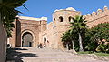
Bab Oudaïa Gate

Mausoleum of Mohammed V

Possible descendants of the Barbary lion at Rabat Zoo near the city


Notable people from Rabat
Politicians
Reuven Abergel, Israeli social and political activist
Marc Perrin de Brichambaut, French judge and diplomat
Dominique de Villepin, former Prime Minister of France
Richard Dell'Agnola, French politician
Omar El Bahraoui, former mayor of Rabat
David Levy, Israeli politician
Maxim Levy, Israeli politician
Bernard Squarcini, French counter-terrorism director
Mohammed Naciri, REGIONAL DIRECTOR OF ARAB STATES/NORTH AFRICA, UN WOMEN
Scientists, writers and philosophers:
Abdellah Taïa, writer
Linda Ashcroft, writer and artist
Robert Assaraf, historian
Alain Badiou, French philosopher
Mohammed Suerte Bennani, Moroccan novelist
Mohammed Berrada, Moroccan novelist, literary critic, and translator
Helene Hagan, Franco-American writer anthropologist
Abdelfattah Kilito, Moroccan writer
Bahaa Trabelsi, Moroccan novelist
Mohammad Naciri, Regional Director for the Arab States and Asia Pacific for the United Nations Entity for Gender Equality and the Empowerment of Women (UN Women)
Artists
Samira Said, Moroccan singer
Saad Lamjarred, Moroccan singer- Hajib, Moroccan Chaabi singer
Shlomo Bar, Israeli musician
Fabienne Égal, French announcer and television host
Roland Giraud, French actor
Macha Méril, French actress and writer
Daniel Siboni, French photographer
French Montana, American Hip-Hop Artist
Bryce Hudson, American painter and photographer
Sportsmen
Saïd Aït-Bahi, Moroccan footballer
Bouabid Bouden, Moroccan footballer
Custodio Dos Reis, French road bicycle racer
Younes Khattabi, Moroccan rugby league player
Ait Hammi Miloud, Moroccan Olympic boxer
Jean Patrick Lesobre, French Rugby Union player
Younès Moudrik, Moroccan long jumper
Brahim Taleb, Moroccan long distance runner
Royal descendants
Mohammed VI of Morocco, King of Morocco- Prince Fakhruddin of Egypt
- Prince Jacques, Duke of Orléans
- Prince Michel, Count of Évreux
- Prince Moulay Rachid of Morocco
- Princess Lalla Aicha of Morocco
Transport
Air
Rabat's main airport is Rabat–Salé Airport.
Trains
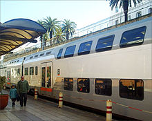
Rabat-Ville Railway Station
Rabat is served by two principal railway stations run by the national rail service, the ONCF.
Rabat-Ville is the main inter-city station, from which trains run south to Casablanca, Marrakech and El Jadida, north to Tanger, or east to Meknes, Fes, Taza and Oujda.
ONCF operates the Le Bouregreg urban rail for Rabat-Salé agglomeration.
Tram
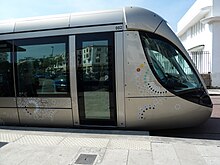
Rabat-Salé tramway
The Rabat-Salé tramway is a tram system which was put into service on May 23, 2011 in the Moroccan cities of Rabat and Salé. The network has two lines for a total length of 19 km (12 miles) and 31 stops. It is operated by Veolia Transdev with Alstom Citadis trams.
Sports
Prince Moulay Abdellah Stadium (Arabic: مركب الأمير مولاي عبد لله) is a multi-purpose stadium in Rabat, Morocco. It is named after Prince Moulay Abdellah. It was built in 1983 and is the home ground of FAR Rabat. It is used mostly for football matches, and it can also stage athletics. The stadium holds 52,000. Since 2008 it is host of the Meeting International Mohammed VI d'Athlétisme de Rabat.
Rabat will host the 2019 African Games.
Football
The local football teams are:
- FAR de Rabat
- FUS de Rabat
- Stade Marocain
- Hilal de Rabat
- Union de Touarga
- Youssoufia Club de Rabat
Handball
- FUS de Rabat
- Le Stade Marocain
- Les FAR de Rabat
Basketball
The local basketball teams are:
- FUS de Rabat
- FAR de Rabat
- Moghreb de Rabat
Volleyball
- FUS de Rabat
- FAR de Rabat
- Crédit agricole Rabat
Gallery
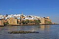
River Bou Regreg and the Kasbah of the Udayas

Chellah Minaret
Tour Hassan and Mausoleum of Mohammed V

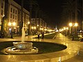
Rabat, Mohammed V Avenue
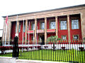
The Parliament building

Rabat as seen from Spot Satellite
Rabat downtown

Rabat–Salé Airport

Sunset next to Quartier l'Océan


International relations
Twin towns—sister cities
Rabat is twinned with:
|
|
References
- Notes
^ "Hong Kong Observatory". Hong Kong Observatory. Retrieved 2009-08-17..mw-parser-output cite.citationfont-style:inherit.mw-parser-output qquotes:"""""""'""'".mw-parser-output code.cs1-codecolor:inherit;background:inherit;border:inherit;padding:inherit.mw-parser-output .cs1-lock-free abackground:url("//upload.wikimedia.org/wikipedia/commons/thumb/6/65/Lock-green.svg/9px-Lock-green.svg.png")no-repeat;background-position:right .1em center.mw-parser-output .cs1-lock-limited a,.mw-parser-output .cs1-lock-registration abackground:url("//upload.wikimedia.org/wikipedia/commons/thumb/d/d6/Lock-gray-alt-2.svg/9px-Lock-gray-alt-2.svg.png")no-repeat;background-position:right .1em center.mw-parser-output .cs1-lock-subscription abackground:url("//upload.wikimedia.org/wikipedia/commons/thumb/a/aa/Lock-red-alt-2.svg/9px-Lock-red-alt-2.svg.png")no-repeat;background-position:right .1em center.mw-parser-output .cs1-subscription,.mw-parser-output .cs1-registrationcolor:#555.mw-parser-output .cs1-subscription span,.mw-parser-output .cs1-registration spanborder-bottom:1px dotted;cursor:help.mw-parser-output .cs1-hidden-errordisplay:none;font-size:100%.mw-parser-output .cs1-visible-errorfont-size:100%.mw-parser-output .cs1-subscription,.mw-parser-output .cs1-registration,.mw-parser-output .cs1-formatfont-size:95%.mw-parser-output .cs1-kern-left,.mw-parser-output .cs1-kern-wl-leftpadding-left:0.2em.mw-parser-output .cs1-kern-right,.mw-parser-output .cs1-kern-wl-rightpadding-right:0.2em
^ abc "Population légale d'après les résultats du RGPH 2014 sur le Bulletin officiel N° 6354" (pdf). Haut-Commissariat au Plan (in Arabic). Retrieved 2015-07-11.
^ "Décret fixant le nom des régions" (PDF). Portail National des Collectivités Territoriales (in French). Archived from the original (pdf) on 2015-05-18. Retrieved 2015-07-11.
^ "Top travel destinations for 2013 - CNN.com". Edition.cnn.com. 2013-01-02. Retrieved 2013-03-12.
^ "Abd al-Mumin facts, information, pictures | Encyclopedia.com articles about Abd al-Mumin". www.encyclopedia.com. Retrieved 2017-12-22.
^ Kjeilen, Tore. "Rabat - LookLex Encyclopaedia". looklex.com. Retrieved 2017-12-22.
^ History of Morocco, Henri Terrasse, 1952
^ Levant, Yves; Maziane, Leïla (2017-01-02). "The Republic of Salé (1627–1641/1666); an alternative pirate organization model?". Management & Organizational History. 12 (1): 1–29. doi:10.1080/17449359.2017.1296773. ISSN 1744-9359.
^ "History of Morocco". Encyclopedia Britannica. Retrieved 2017-12-22.
^ Morocco: The Islamist Awakening and Other Challenges 2005, Marvine Howe
^ Pike, John. "Sidi Slimane Air Base, Morocco - United States Nuclear Forces". Globalsecurity.org. Retrieved 2009-05-06.
^ Rabat, Morocco Page. Directory of Cities, Towns, and Regions in Morocco
^ "Rabat Climate Normals 1961–1990". National Oceanic and Atmospheric Administration. Retrieved October 14, 2016.
^
"Klimatafel von Rabat-Salé (Int. Flugh.) / Marokko" (PDF). Baseline climate means (1961–1990) from stations all over the world (in German). Deutscher Wetterdienst. Retrieved October 14, 2016.
^
"Station Rabat" (PDF) (in French). Météo Climat. Retrieved October 14, 2016.
^ Bill K. Anderson, Mawazine — The binding of cultures, the channeling of acceptance, http://digitaljournal.com/, 5 June 2014
^ "::Bethlehem Municipality::". www.bethlehem-city.org. Archived from the original on 2010-07-24. Retrieved 2009-10-10.
^ "Kardeş Şehirler". Bursa Büyükşehir Belediyesi Basın Koordinasyon Merkez. Tüm Hakları Saklıdır. Retrieved 2013-07-27.
^ "Guangzhou and Rabat sign sister city agreement". Archived from the original on 2 April 2015. Retrieved 17 March 2015.
^ "Lisboa - Geminações de Cidades e Vilas" [Lisbon - Twinning of Cities and Towns]. Associação Nacional de Municípios Portugueses [National Association of Portuguese Municipalities] (in Portuguese). Retrieved 2013-08-23.
^ "Acordos de Geminação, de Cooperação e/ou Amizade da Cidade de Lisboa" [Lisbon - Twinning Agreements, Cooperation and Friendship]. Camara Municipal de Lisboa (in Portuguese). Retrieved 2013-08-23.
^ "Mapa Mundi de las ciudades hermanadas". Ayuntamiento de Madrid. Archived from the original on 2012-05-26.
^ "AN^MAR - Red de Hermanamientos entre Ciudades Marroquies y Andaluzas - Convenios y hermanamientas". An-mar.org. 2006-05-01. Retrieved 2011-09-15.
^ "Cooperation Internationale" (in French). © 2003 City of Tunis Portal. Archived from the original on October 11, 2008. Retrieved 2009-01-31.
Bibliography
External links
| Wikimedia Commons has media related to Rabat. |
| Wikivoyage has a travel guide for Rabat. |
- Rabat Touristic Portal
- Entry in Lexicorient
- Rabat photo gallery
"Rabat". Islamic Cultural Heritage Database. Istanbul: Organisation of Islamic Cooperation, Research Centre for Islamic History, Art and Culture. Archived from the original on 2013-04-27.
ArchNet.org. "Rabat". Cambridge, Massachusetts, USA: MIT School of Architecture and Planning. Archived from the original on 2013-12-02.
Capital: Rabat | |
| Provinces and Prefectures |
|
| Cities |
|
World Heritage Sites in Morocco | ||
|---|---|---|
| Northern |
| |
| Central |
| |
| Southern |
| |
Coordinates: 34°01′15″N 6°50′30″W / 34.020882°N 6.84165°W / 34.020882; -6.84165
Authority control |
|
|---|
