National Register of Historic Places listings in Floyd County, Virginia
[dummy-text]
National Register of Historic Places listings in Floyd County, Virginia
Jump to navigation
Jump to search

Location of Floyd County in Virginia
This is a list of the National Register of Historic Places listings in Floyd County, Virginia.
This is intended to be a complete list of the properties and districts on the National Register of Historic Places in Floyd County, Virginia, United States. The locations of National Register properties and districts for which the latitude and longitude coordinates are included below, may be seen in a Google map.[1]
There are 9 properties and districts listed on the National Register in the county.
This National Park Service list is complete through NPS recent listings posted November 2, 2018.[2]
Current listings[edit]
| [3] | Name on the Register[4] | Image | Date listed[5] | Location | City or town | Description |
|---|---|---|---|---|---|---|
1 | Buffalo Mountain Presbyterian Church and Cemetery |  | March 30, 2007 (#07000229) | 2102 Childress Rd. 36°46′41″N 80°31′01″W / 36.778056°N 80.516944°W / 36.778056; -80.516944 (Buffalo Mountain Presbyterian Church and Cemetery) | Willis | Church is in Carroll County; cemetery is in Floyd County |
2 | Floyd Historic District |  | November 16, 2005 (#05001266) | Centered along Main and Osford Sts. between Penn Ave., and Baker St. and Sweeney and Nira St. 36°54′40″N 80°19′12″W / 36.911111°N 80.320000°W / 36.911111; -80.320000 (Floyd Historic District) | Floyd | |
3 | Floyd Presbyterian Church |  | May 17, 1976 (#76002105) | U.S. Route 221 36°54′41″N 80°19′05″W / 36.911389°N 80.317917°W / 36.911389; -80.317917 (Floyd Presbyterian Church) | Floyd | |
4 | Glenanna |  | May 16, 2002 (#02000523) | 204 W. Main St. 36°54′41″N 80°19′19″W / 36.911250°N 80.321806°W / 36.911250; -80.321806 (Glenanna) | Floyd | |
5 | Oakdale | 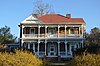 | March 17, 2010 (#10000090) | 5773 Franklin Pike 36°58′17″N 80°08′35″W / 36.971389°N 80.143056°W / 36.971389; -80.143056 (Oakdale) | Floyd | |
6 | Phlegar Farm |  | June 22, 2003 (#03000565) | Off Christiansburg Pike 36°55′30″N 80°18′17″W / 36.925000°N 80.304861°W / 36.925000; -80.304861 (Phlegar Farm) | Floyd | |
7 | Slate Mountain Presbyterian Church and Cemetery |  | March 30, 2007 (#07000227) | Rock Church Rd. 36°46′42″N 80°23′31″W / 36.778333°N 80.391944°W / 36.778333; -80.391944 (Slate Mountain Presbyterian Church and Cemetery) | Meadows of Dan | |
8 | Willis Presbyterian Church and Cemetery |  | March 30, 2007 (#07000226) | 5733 Floyd Highway, S. 36°51′22″N 80°29′07″W / 36.856111°N 80.485139°W / 36.856111; -80.485139 (Willis Presbyterian Church and Cemetery) | Willis | |
9 | West Fork Furnace |  | June 5, 2009 (#09000414) | Old Furnace Rd. 36°50′03″N 80°22′31″W / 36.834167°N 80.375278°W / 36.834167; -80.375278 (West Fork Furnace) | Floyd |
See also[edit]
| Wikimedia Commons has media related to National Register of Historic Places in Floyd County, Virginia. |
- List of National Historic Landmarks in Virginia
- National Register of Historic Places listings in Virginia
References[edit]
^ The latitude and longitude information provided in this table was derived originally from the National Register Information System, which has been found to be fairly accurate for about 99% of listings. For about 1% of NRIS original coordinates, experience has shown that one or both coordinates are typos or otherwise extremely far off; some corrections may have been made. A more subtle problem causes many locations to be off by up to 150 yards, depending on location in the country: most NRIS coordinates were derived from tracing out latitude and longitudes from USGS topographical quadrant maps created under the North American Datum of 1927, which differs from the current, highly accurate WGS84 GPS system used by most on-line maps. Chicago is about right, but NRIS longitudes in Washington are higher by about 4.5 seconds, and are lower by about 2.0 seconds in Maine. Latitudes differ by about 1.0 second in Florida. Some locations in this table may have been corrected to current GPS standards.
^ "National Register of Historic Places: Weekly List Actions". National Park Service, United States Department of the Interior. Retrieved on November 2, 2018.
^ Numbers represent an ordering by significant words. Various colorings, defined here, differentiate National Historic Landmarks and historic districts from other NRHP buildings, structures, sites or objects.
^ National Park Service (2008-04-24). "National Register Information System". National Register of Historic Places. National Park Service..mw-parser-output cite.citationfont-style:inherit.mw-parser-output qquotes:"""""""'""'".mw-parser-output code.cs1-codecolor:inherit;background:inherit;border:inherit;padding:inherit.mw-parser-output .cs1-lock-free abackground:url("//upload.wikimedia.org/wikipedia/commons/thumb/6/65/Lock-green.svg/9px-Lock-green.svg.png")no-repeat;background-position:right .1em center.mw-parser-output .cs1-lock-limited a,.mw-parser-output .cs1-lock-registration abackground:url("//upload.wikimedia.org/wikipedia/commons/thumb/d/d6/Lock-gray-alt-2.svg/9px-Lock-gray-alt-2.svg.png")no-repeat;background-position:right .1em center.mw-parser-output .cs1-lock-subscription abackground:url("//upload.wikimedia.org/wikipedia/commons/thumb/a/aa/Lock-red-alt-2.svg/9px-Lock-red-alt-2.svg.png")no-repeat;background-position:right .1em center.mw-parser-output .cs1-subscription,.mw-parser-output .cs1-registrationcolor:#555.mw-parser-output .cs1-subscription span,.mw-parser-output .cs1-registration spanborder-bottom:1px dotted;cursor:help.mw-parser-output .cs1-hidden-errordisplay:none;font-size:100%.mw-parser-output .cs1-visible-errorfont-size:100%.mw-parser-output .cs1-subscription,.mw-parser-output .cs1-registration,.mw-parser-output .cs1-formatfont-size:95%.mw-parser-output .cs1-kern-left,.mw-parser-output .cs1-kern-wl-leftpadding-left:0.2em.mw-parser-output .cs1-kern-right,.mw-parser-output .cs1-kern-wl-rightpadding-right:0.2em
^ The eight-digit number below each date is the number assigned to each location in the National Register Information System database, which can be viewed by clicking the number.
U.S. National Register of Historic Places in Virginia | ||
|---|---|---|
| Lists by county |
|   |
| Lists by city |
| |
| Other lists |
| |
| ||
Municipalities and communities of Floyd County, Virginia, United States | ||
|---|---|---|
County seat: Floyd | ||
| Town |
|  |
| Unincorporated communities |
| |
Categories:
- National Register of Historic Places in Floyd County, Virginia
- Lists of National Register of Historic Places in Virginia by county
(window.RLQ=window.RLQ||).push(function()mw.config.set("wgPageParseReport":"limitreport":"cputime":"0.368","walltime":"0.489","ppvisitednodes":"value":4506,"limit":1000000,"ppgeneratednodes":"value":0,"limit":1500000,"postexpandincludesize":"value":115111,"limit":2097152,"templateargumentsize":"value":6020,"limit":2097152,"expansiondepth":"value":11,"limit":40,"expensivefunctioncount":"value":0,"limit":500,"unstrip-depth":"value":1,"limit":20,"unstrip-size":"value":5473,"limit":5000000,"entityaccesscount":"value":1,"limit":400,"timingprofile":["100.00% 324.466 1 -total"," 34.30% 111.305 1 Template:NRHP_header"," 31.38% 101.810 9 Template:NRHP_row"," 27.36% 88.764 1 Template:NRISref"," 26.20% 85.008 1 Template:Cite_web"," 11.84% 38.410 1 Template:Commons_category"," 8.76% 28.408 14 Template:NRHP_color"," 8.33% 27.020 10 Template:Designation/color"," 7.54% 24.480 9 Template:Coord"," 6.41% 20.809 9 Template:Dts"],"scribunto":"limitreport-timeusage":"value":"0.097","limit":"10.000","limitreport-memusage":"value":3590585,"limit":52428800,"cachereport":"origin":"mw1334","timestamp":"20181111235258","ttl":1900800,"transientcontent":false);mw.config.set("wgBackendResponseTime":98,"wgHostname":"mw1268"););


