National Register of Historic Places listings in Amelia County, Virginia
[dummy-text]
National Register of Historic Places listings in Amelia County, Virginia
Jump to navigation
Jump to search
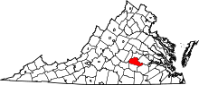
Location of Amelia County in Virginia
This is a list of the National Register of Historic Places listings in Amelia County, Virginia.
This is intended to be a complete list of the properties and districts on the National Register of Historic Places in Amelia County, Virginia, United States. The locations of National Register properties and districts for which the latitude and longitude coordinates are included below, may be seen in a Google map.[1]
There are 10 properties and districts listed on the National Register in the county, including 1 National Historic Landmark.
This National Park Service list is complete through NPS recent listings posted November 2, 2018.[2]
Current listings[edit]
| [3] | Name on the Register[4] | Image | Date listed[5] | Location | City or town | Description |
|---|---|---|---|---|---|---|
1 | Barrett-Chumney House |  | November 18, 2011 (#11000832) | 2400 Richmond Rd. 37°13′43″N 77°50′42″W / 37.228611°N 77.845000°W / 37.228611; -77.845000 (Barrett-Chumney House) | Amelia Courthouse | |
2 | Dykeland | 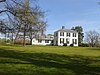 | May 8, 1987 (#87000721) | Dykeland Rd. 37°24′22″N 77°54′31″W / 37.406111°N 77.908611°W / 37.406111; -77.908611 (Dykeland) | Chula | |
3 | Egglestetton |  | March 28, 1980 (#80004167) | Northwest of Chula 37°23′56″N 77°59′05″W / 37.398750°N 77.984722°W / 37.398750; -77.984722 (Egglestetton) | Chula | |
4 | Farmer House | 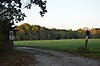 | November 17, 1978 (#78003004) | 3 miles (4.8 km) southeast of Deatonville on Jennings Ordinary Rd. 37°17′10″N 78°09′22″W / 37.286111°N 78.156111°W / 37.286111; -78.156111 (Farmer House) | Deatonville | |
5 | Haw Branch |  | April 2, 1973 (#73001992) | North of Amelia off Haw Branch Ln. 37°24′38″N 78°01′13″W / 37.410556°N 78.020278°W / 37.410556; -78.020278 (Haw Branch) | Amelia Courthouse | |
6 | Ingleside |  | September 12, 1997 (#97001071) | 10920 Rodophil Rd. 37°22′12″N 78°09′34″W / 37.370000°N 78.159444°W / 37.370000; -78.159444 (Ingleside) | Amelia Courthouse | |
7 | St. John's Church | 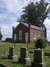 | November 16, 1978 (#78003003) | 3.8 miles (6.1 km) west on Grub Hill Church Rd. 37°23′59″N 77°58′12″W / 37.399722°N 77.970000°W / 37.399722; -77.970000 (St. John's Church) | Chula | |
8 | Sayler's Creek Battlefield |  | February 4, 1985 (#85002436) | Sayler's Creek, James Towne, and Bunker Hill Rds. 37°18′28″N 78°13′40″W / 37.307778°N 78.227778°W / 37.307778; -78.227778 (Sayler's Creek Battlefield) | Farmville | |
9 | Wigwam |  | November 25, 1969 (#69000220) | 8 miles (13 km) northwest of Chula 37°28′18″N 77°59′53″W / 37.471667°N 77.998056°W / 37.471667; -77.998056 (Wigwam) | Chula | |
10 | Winterham |  | October 15, 2002 (#02001183) | 11440 Grub Hill Church Rd. 37°22′46″N 77°58′39″W / 37.379444°N 77.977500°W / 37.379444; -77.977500 (Winterham) | Winterham |
See also[edit]
| Wikimedia Commons has media related to National Register of Historic Places in Amelia County, Virginia. |
- List of National Historic Landmarks in Virginia
- National Register of Historic Places listings in Virginia
References[edit]
^ The latitude and longitude information provided in this table was derived originally from the National Register Information System, which has been found to be fairly accurate for about 99% of listings. For about 1% of NRIS original coordinates, experience has shown that one or both coordinates are typos or otherwise extremely far off; some corrections may have been made. A more subtle problem causes many locations to be off by up to 150 yards, depending on location in the country: most NRIS coordinates were derived from tracing out latitude and longitudes from USGS topographical quadrant maps created under the North American Datum of 1927, which differs from the current, highly accurate WGS84 GPS system used by most on-line maps. Chicago is about right, but NRIS longitudes in Washington are higher by about 4.5 seconds, and are lower by about 2.0 seconds in Maine. Latitudes differ by about 1.0 second in Florida. Some locations in this table may have been corrected to current GPS standards.
^ "National Register of Historic Places: Weekly List Actions". National Park Service, United States Department of the Interior. Retrieved on November 2, 2018.
^ Numbers represent an ordering by significant words. Various colorings, defined here, differentiate National Historic Landmarks and historic districts from other NRHP buildings, structures, sites or objects.
^ National Park Service (2008-04-24). "National Register Information System". National Register of Historic Places. National Park Service..mw-parser-output cite.citationfont-style:inherit.mw-parser-output qquotes:"""""""'""'".mw-parser-output code.cs1-codecolor:inherit;background:inherit;border:inherit;padding:inherit.mw-parser-output .cs1-lock-free abackground:url("//upload.wikimedia.org/wikipedia/commons/thumb/6/65/Lock-green.svg/9px-Lock-green.svg.png")no-repeat;background-position:right .1em center.mw-parser-output .cs1-lock-limited a,.mw-parser-output .cs1-lock-registration abackground:url("//upload.wikimedia.org/wikipedia/commons/thumb/d/d6/Lock-gray-alt-2.svg/9px-Lock-gray-alt-2.svg.png")no-repeat;background-position:right .1em center.mw-parser-output .cs1-lock-subscription abackground:url("//upload.wikimedia.org/wikipedia/commons/thumb/a/aa/Lock-red-alt-2.svg/9px-Lock-red-alt-2.svg.png")no-repeat;background-position:right .1em center.mw-parser-output .cs1-subscription,.mw-parser-output .cs1-registrationcolor:#555.mw-parser-output .cs1-subscription span,.mw-parser-output .cs1-registration spanborder-bottom:1px dotted;cursor:help.mw-parser-output .cs1-hidden-errordisplay:none;font-size:100%.mw-parser-output .cs1-visible-errorfont-size:100%.mw-parser-output .cs1-subscription,.mw-parser-output .cs1-registration,.mw-parser-output .cs1-formatfont-size:95%.mw-parser-output .cs1-kern-left,.mw-parser-output .cs1-kern-wl-leftpadding-left:0.2em.mw-parser-output .cs1-kern-right,.mw-parser-output .cs1-kern-wl-rightpadding-right:0.2em
^ The eight-digit number below each date is the number assigned to each location in the National Register Information System database, which can be viewed by clicking the number.
U.S. National Register of Historic Places in Virginia | ||
|---|---|---|
| Lists by county |
|   |
| Lists by city |
| |
| Other lists |
| |
| ||
Municipalities and communities of Amelia County, Virginia, United States | ||
|---|---|---|
County seat: Amelia Courthouse | ||
| CDP |
|  |
| Unincorporated communities |
| |
Categories:
- National Register of Historic Places in Amelia County, Virginia
- Lists of National Register of Historic Places in Virginia by county
(window.RLQ=window.RLQ||).push(function()mw.config.set("wgPageParseReport":"limitreport":"cputime":"0.412","walltime":"0.578","ppvisitednodes":"value":4930,"limit":1000000,"ppgeneratednodes":"value":0,"limit":1500000,"postexpandincludesize":"value":120663,"limit":2097152,"templateargumentsize":"value":6403,"limit":2097152,"expansiondepth":"value":11,"limit":40,"expensivefunctioncount":"value":0,"limit":500,"unstrip-depth":"value":1,"limit":20,"unstrip-size":"value":5482,"limit":5000000,"entityaccesscount":"value":1,"limit":400,"timingprofile":["100.00% 420.971 1 -total"," 46.93% 197.551 10 Template:NRHP_row"," 24.18% 101.802 1 Template:NRHP_header"," 18.92% 79.639 1 Template:NRISref"," 17.90% 75.341 1 Template:Cite_web"," 12.35% 52.007 1 Template:Commons_category"," 9.77% 41.121 10 Template:Coord"," 8.72% 36.729 3 Template:Convert"," 8.51% 35.823 16 Template:NRHP_color"," 7.94% 33.433 11 Template:Designation/color"],"scribunto":"limitreport-timeusage":"value":"0.122","limit":"10.000","limitreport-memusage":"value":4906039,"limit":52428800,"cachereport":"origin":"mw1272","timestamp":"20181111222958","ttl":1900800,"transientcontent":false);mw.config.set("wgBackendResponseTime":103,"wgHostname":"mw1267"););


