A483 road
A483 | |
|---|---|
 | |
 | |
| Route information | |
| Maintained by Highways England, English local authorities, South Wales Trunk Road Agency and North & Mid Wales Trunk Road Agency | |
| Length | 153 mi (246 km) |
| Major junctions | |
| North end | Swansea |
| |
| South end | Chester |
| Location | |
| Primary destinations | Pontarddulais Ammanford Llandeilo Llandovery Llanwrtyd Wells Builth Wells Llandrindod Wells Newtown Welshpool Oswestry Ruabon Wrexham |
| Road network | |
| |

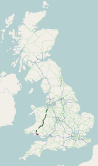
The A483, also known as the Swansea to Chester Trunk Road, is a major road in the United Kingdom. It runs from Swansea in Wales to Chester in England via Llandovery, Llandrindod Wells, Oswestry and Wrexham, a distance of around 153 miles (246 km).
Contents
1 Route description
1.1 Swansea
1.2 Carmarthenshire
1.3 Powys
1.4 Shropshire
1.5 Wrexham
1.6 Cheshire
2 Future
3 See also
4 References
5 External links
Route description
Swansea
The A483 begins at junction 42 of the M4 motorway, just east of Swansea. From here, it travels west along the Fabian Way towards Swansea city centre, where it turns to a northwesterly direction. It meets the M4 again at junction 47 at Penllergaer, after which it multiplexes with the A48 along Swansea Road, Bryntirion Road and Bolgoed Road to Pontarddulais.
Carmarthenshire
After Pontarddulais, the route continues along Heol Fforest and Carmarthen Road. It diverges from the A48 at the terminus of the M4, junction 49, turning northeast towards Ammanford and then north towards Llandeilo. At Llandeilo it meets the A40, then multiplexes with this route as far as Llandovery. From here, it continues north into Powys.
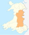
Powys
The A483 continues through Llanwrtyd Wells, Builth Wells (where it intersects with the A470) and Llandrindod Wells. It intersects with the A44 at Crossgates, just north of Llandrindod Wells, then continues to Newtown, where it passes under the Cambrian Line at the Dolfor Road Railway Bridge. This low bridge, with a height restriction of 13 ft 3 in (4.04 m), has been hit by high vehicles on many occasions. From Newtown the road continues to Welshpool, running roughly parallel to the River Severn, before crossing the border into England at Llanymynech.
Shropshire
From Llanymynech, the A483 continues north, bypassing Oswestry. Here, it picks up a multiplex with the A5; the two routes then cross into Wales at Chirk.
Wrexham
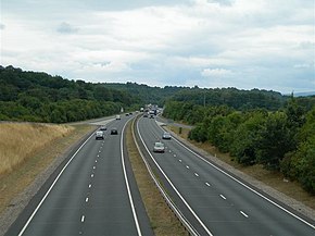
After the A5 diverges to the west at Chirk, the A483 crosses the River Dee, then reaches Ruabon. Here, it becomes a dual carriageway with numbered grade-separated junctions starting from 1. The route then bypasses Wrexham and Gresford before crossing back into England; the final numbered junction is junction 7 at the village of Rossett, just south of the border.
Cheshire
Just south of Chester, the A483 intersects with the A55 North Wales Expressway. It then continues as a single carriageway to its terminus at the city centre, crossing the Grosvenor Bridge over the Dee.
Future
There have been calls to upgrade the road from Shrewsbury to Wrexham, including the section of the A483 from Oswestry to Ruabon, to dual carriageway. There has also been a campaign by residents of Llanymynech and nearby Pant for an A483 bypass around these villages.[1]
See also
- Trunk roads in Wales
References
^ "Roads minister given tour of problem A5 and A483 in Shropshire and Mid Wales". Shropshire Star. 3 March 2017. Retrieved 3 March 2018..mw-parser-output cite.citationfont-style:inherit.mw-parser-output qquotes:"""""""'""'".mw-parser-output code.cs1-codecolor:inherit;background:inherit;border:inherit;padding:inherit.mw-parser-output .cs1-lock-free abackground:url("//upload.wikimedia.org/wikipedia/commons/thumb/6/65/Lock-green.svg/9px-Lock-green.svg.png")no-repeat;background-position:right .1em center.mw-parser-output .cs1-lock-limited a,.mw-parser-output .cs1-lock-registration abackground:url("//upload.wikimedia.org/wikipedia/commons/thumb/d/d6/Lock-gray-alt-2.svg/9px-Lock-gray-alt-2.svg.png")no-repeat;background-position:right .1em center.mw-parser-output .cs1-lock-subscription abackground:url("//upload.wikimedia.org/wikipedia/commons/thumb/a/aa/Lock-red-alt-2.svg/9px-Lock-red-alt-2.svg.png")no-repeat;background-position:right .1em center.mw-parser-output .cs1-subscription,.mw-parser-output .cs1-registrationcolor:#555.mw-parser-output .cs1-subscription span,.mw-parser-output .cs1-registration spanborder-bottom:1px dotted;cursor:help.mw-parser-output .cs1-hidden-errordisplay:none;font-size:100%.mw-parser-output .cs1-visible-errorfont-size:100%.mw-parser-output .cs1-subscription,.mw-parser-output .cs1-registration,.mw-parser-output .cs1-formatfont-size:95%.mw-parser-output .cs1-kern-left,.mw-parser-output .cs1-kern-wl-leftpadding-left:0.2em.mw-parser-output .cs1-kern-right,.mw-parser-output .cs1-kern-wl-rightpadding-right:0.2em
- Google Maps UK
External links
![]() Media related to A483 road at Wikimedia Commons
Media related to A483 road at Wikimedia Commons
- SABRE Roads by 10 - A483
A roads in Zone 4 of the Great Britain road numbering scheme | ||
|---|---|---|
| ||
| ||
| ||
| ||
| Managed by the North and Mid Wales Trunk Road Agent |
|  |
|---|---|---|
| Managed by the South Wales Trunk Road Agent |
| |
| Related topics and further information |
| |
Transport in Carmarthenshire | |||||||
|---|---|---|---|---|---|---|---|
| Roads |
|  | |||||
| Bus |
| ||||||
| Cycling |
| ||||||
| Railway lines |
| ||||||
| Railway stations |
| ||||||
| Air |
| ||||||
Transport in Neath Port Talbot county borough | ||
|---|---|---|
| Road |
|  |
| Bus |
| |
| Cycling |
| |
| Railway lines |
| |
| Railway stations |
| |
| Sea |
| |
| Canals |
| |
Transport in Powys | |||||||
|---|---|---|---|---|---|---|---|
| Road |
|  | |||||
| Footpaths |
| ||||||
| Cycle routes |
| ||||||
| Railway stations |
| ||||||
Transport in Swansea | ||
|---|---|---|
| Roads |
|  |
| Bus |
| |
| Cycling |
| |
| Railway lines |
| |
| Railway stations |
| |
| Air |
| |
| Waterways |
| |
| Sea |
| |
Coordinates: 52°31′44″N 3°15′41″W / 52.52886°N 3.26139°W / 52.52886; -3.26139
